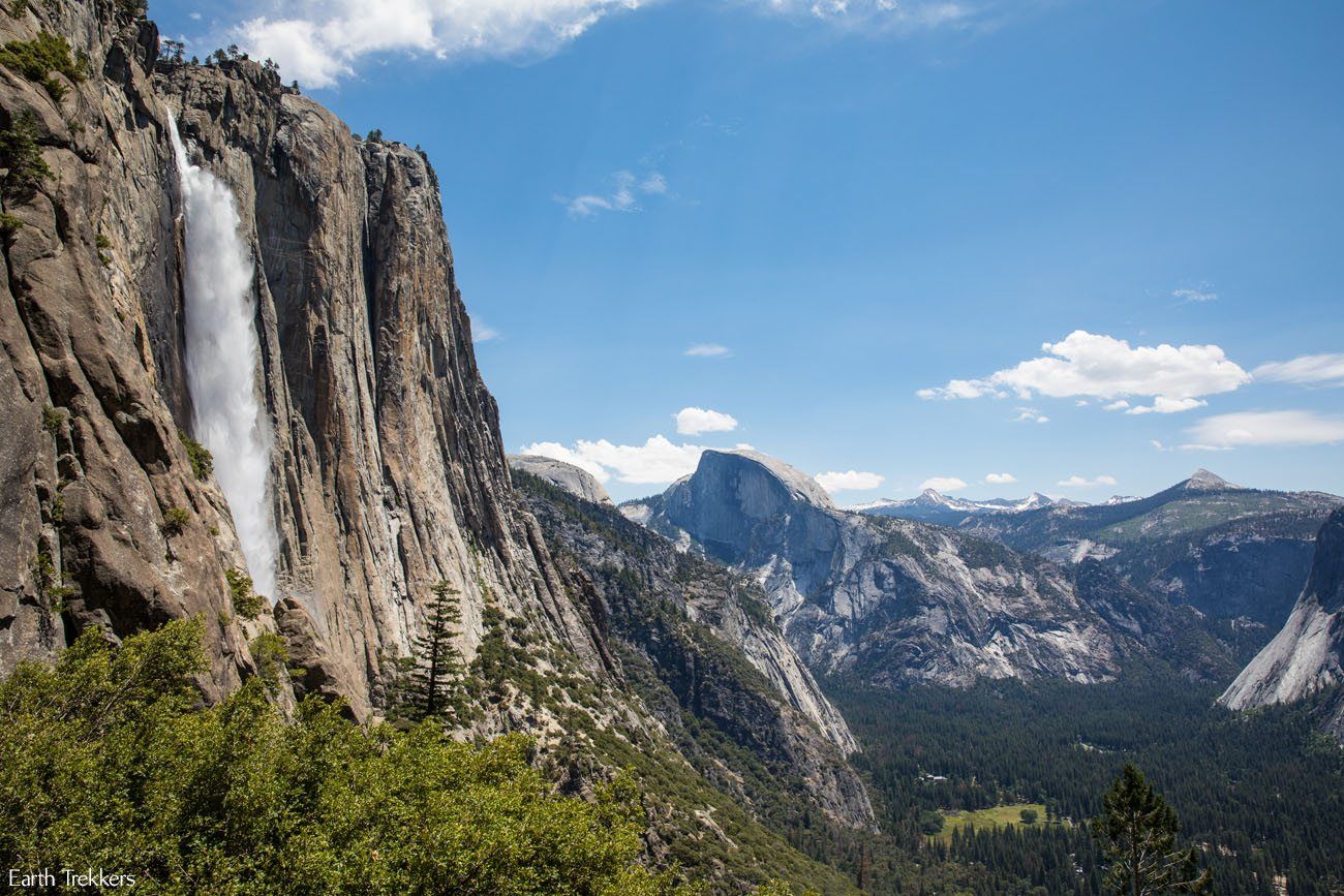
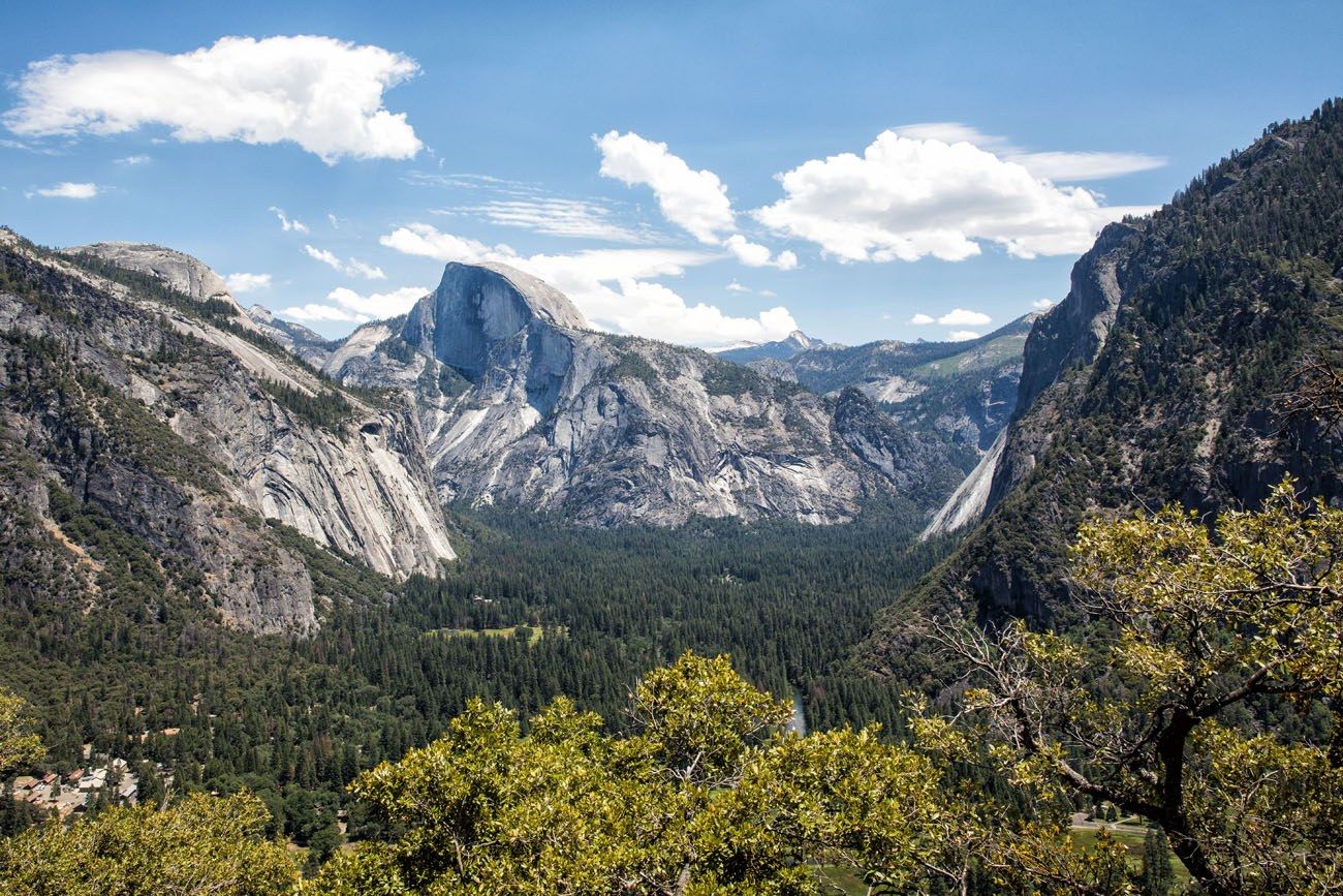
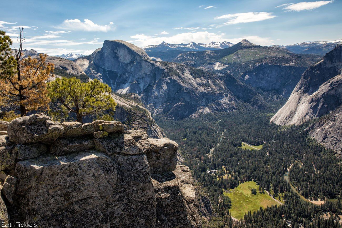
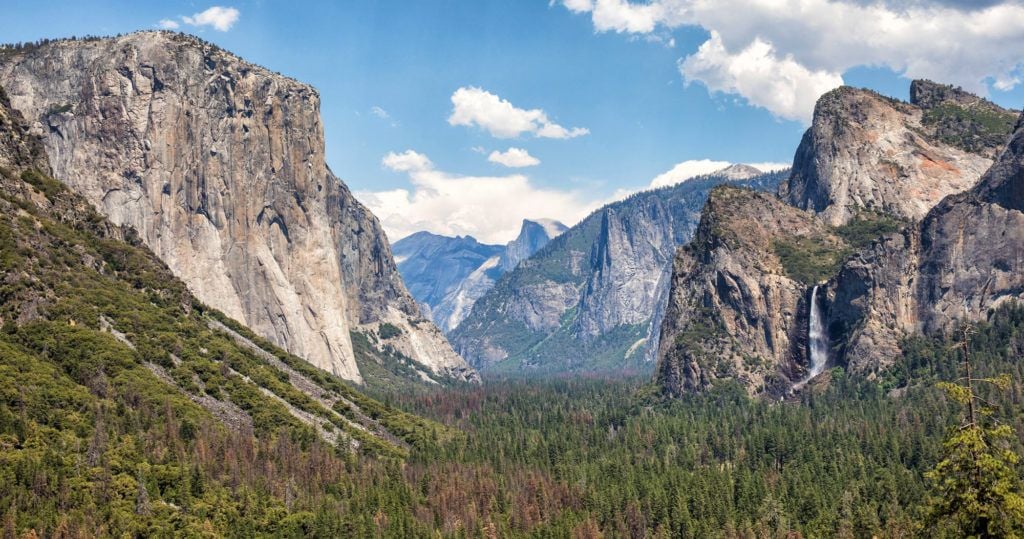
There are a lot of great reasons to hike to the top of Upper Yosemite Falls. From the trail, the views of Yosemite Falls are magnificent. For part of the hike, you are close enough to feel the spray and hear the waterfall thundering down the mountain. Halfway up the climb you get an amazing view of Yosemite Valley, with Half Dome in the distance. Once at the top, watch as the falls plummet down the side of the mountain and get a greater sense of just how far you hiked. And if you have the energy to continue onto Yosemite Point, your reward is one of the best views of Half Dome in all of Yosemite National Park.
This is not a hike to be underestimated. Getting to the top of Upper Yosemite Falls is challenging. Most of the trail is a steady, uphill climb with a relentless number of switchbacks.
Table of Contents
Yosemite Falls Trail Hiking Stats
Distance: 7 miles round trip to the top of Yosemite Falls; 8.7 miles round trip to Yosemite Point
Elevation Gain: 3,000 feet to the top of Yosemite Falls; 3,700 feet to Yosemite Point
Difficulty: Very strenuous
Length of Time: 6 to 8 hours
When to go: Spring, summer, or fall. The Yosemite Falls is at its maximum flow in spring and early summer. By the end of summer into autumn, it could be just a trickle or completely dry.
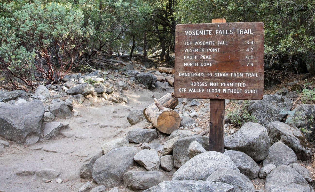
Trailhead: The trail starts at Camp 4 (shuttle stop #7)
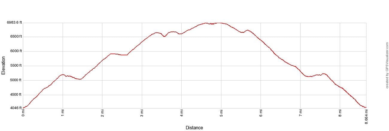
Elevation profile to Yosemite Point
Please practice the seven principles of Leave No Trace: plan ahead, stay on the trail, pack out what you bring to the hiking trail, properly dispose of waste, leave areas as you found them, minimize campfire impacts, be considerate of other hikers, and do not approach or feed wildlife.
Hiking the Upper Yosemite Falls Trail
Step-By-Step Trail Guide
The Trailhead
The trailhead is located in Camp 4, a short walk from the Yosemite Valley Lodge. If you are using the Yosemite shuttle, get off on stop #7 and follow the signs to the Yosemite Falls Trail. Do not take the trail to Lower Yosemite Falls. This is a totally different trail and it does not join up with the trail to Upper Yosemite Falls.
We had a car, so we parked along the road near Camp 4. You can also park at the Yosemite Falls Lodge and cross the street to Camp 4. Parking at Camp 4 is for campers only.
Hiking to the Yosemite Falls Viewpoint
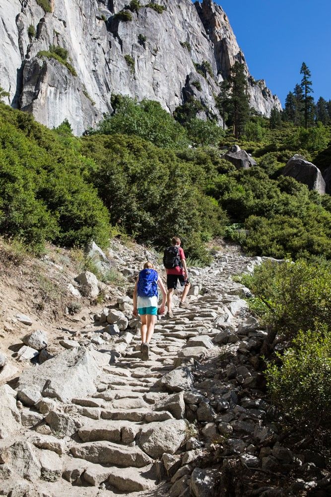
The hike from the valley floor to the viewpoint is a long series of switchbacks and steep trails. It is a strenuous climb and the trail is sandy at times, rocky in other places. Honestly, nothing about this first part of the hike is fun. It’s just about gaining elevation so you can have those awesome views later.
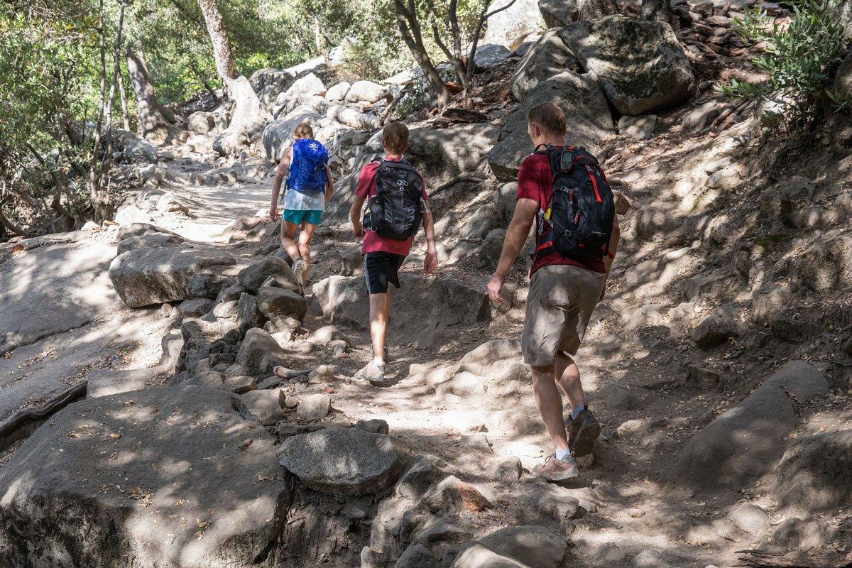
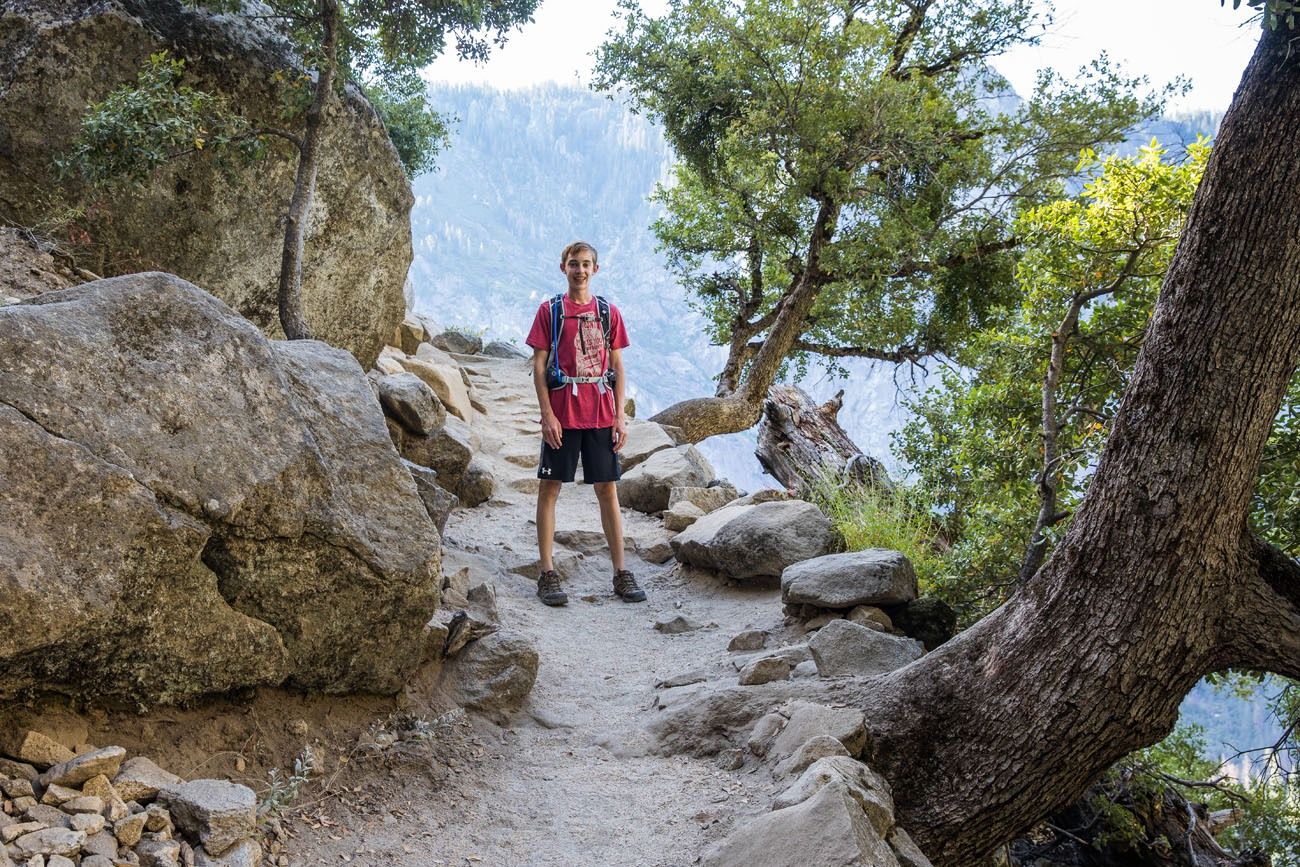
Even though much of this trail is under the shade of trees, the trail is hot, even during the morning hours. Since this hike is on the south side of mountain, it bakes in the sun all day long. We did this hike in July when daytime temperatures reached into the 90’s. It took less than 15 minutes of hiking until all four of us were dripping with sweat, even in the morning. This is a hike you want to start as early as possible.
The View from Columbia Rock
The view from Columbia Rock is one of the best on the entire hike. Here is your chance to capture Yosemite Falls and Half Dome in the same photo.
Just past Columbia Rock, look for a small, unmarked trail that branches off to the right. This trail leads down to “Oh My Gosh Point.” Once you get to the end of the trail you have a great view of Upper, Middle, and Lower Falls and Half Dome. We did not do this, because we were aware of it, but one of our awesome readers wrote in with this information. This viewpoint is described in the National Park Service’s app for Yosemite so it is not “off trail.” Note, if you are afraid of heights, skip this detour. The trail leads to a viewpoint with no railing.
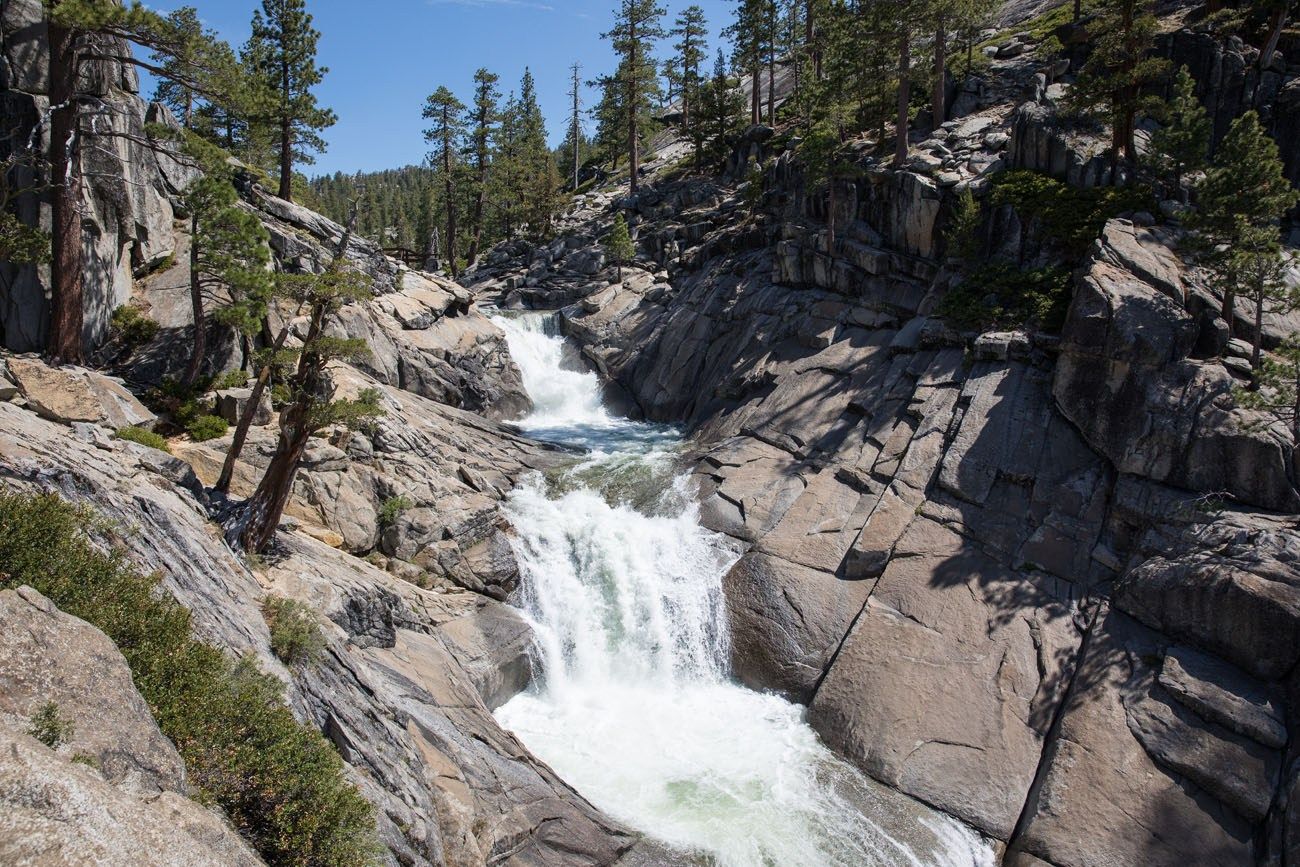
For about a half mile, the trail levels out, and even goes downhill for a little bit. If the Falls are at their maximum, you may even get to feel the spray of the waterfall. Enjoy it. The hardest part of the hike is yet to come.
Hiking to the top of Upper Yosemite Falls
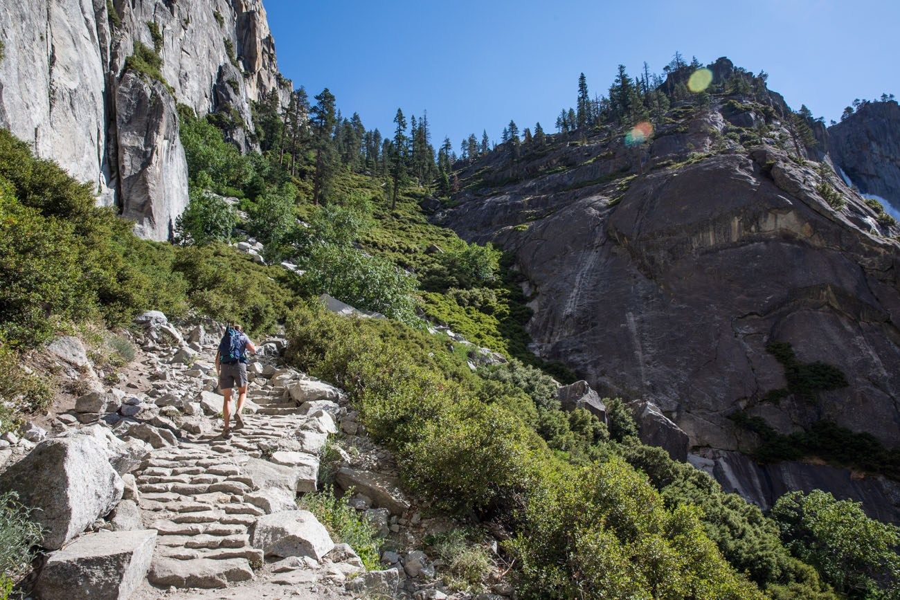
I hope you don’t mind switchbacks, because there are a lot of them on this trail! Now it is one steady thigh-burning, are-we-there-yet climb to the top of Yosemite Falls.
The trail is now rocky and uneven. Crowds on the trail tend to lessen at this point, as some hikers choose to turn around at Columbia Rock.
Once you get to the top, follow the signs to Yosemite Falls overlook and enjoy the view.
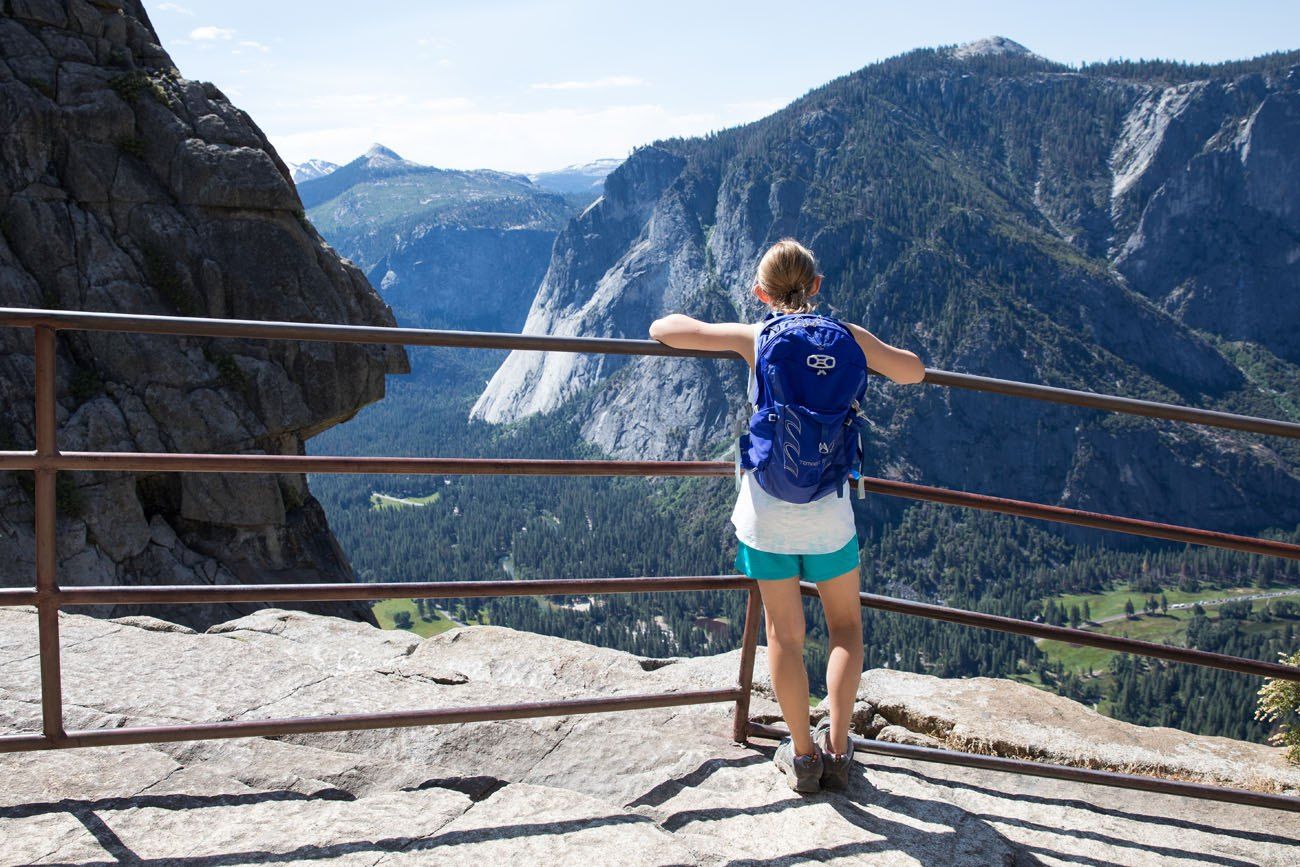
Final trail to the Yosemite Falls overlook
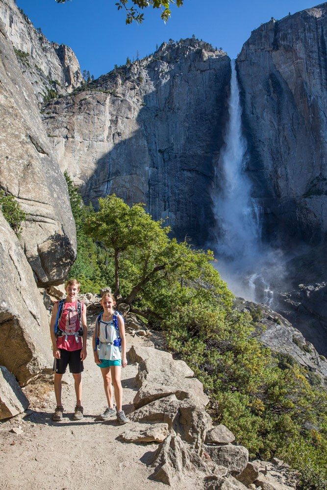
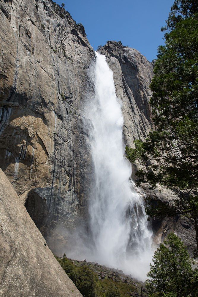
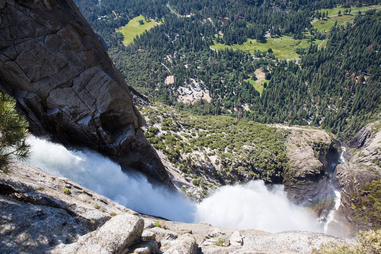
If you want, there is a short trail that leads out to the best view of the top of the falls. Earlier this year, California had record snowfall, which meant that the waterfalls in Yosemite were raging during our visit. Yosemite Falls was literally thundering, something that was not only impressive to see but also to hear.
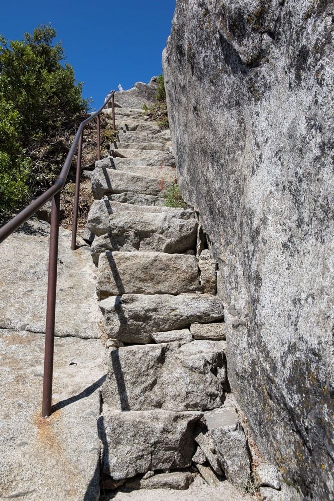
The photo above shows the steps leading down to the viewpoint (I took the photo from the bottom of the steps).
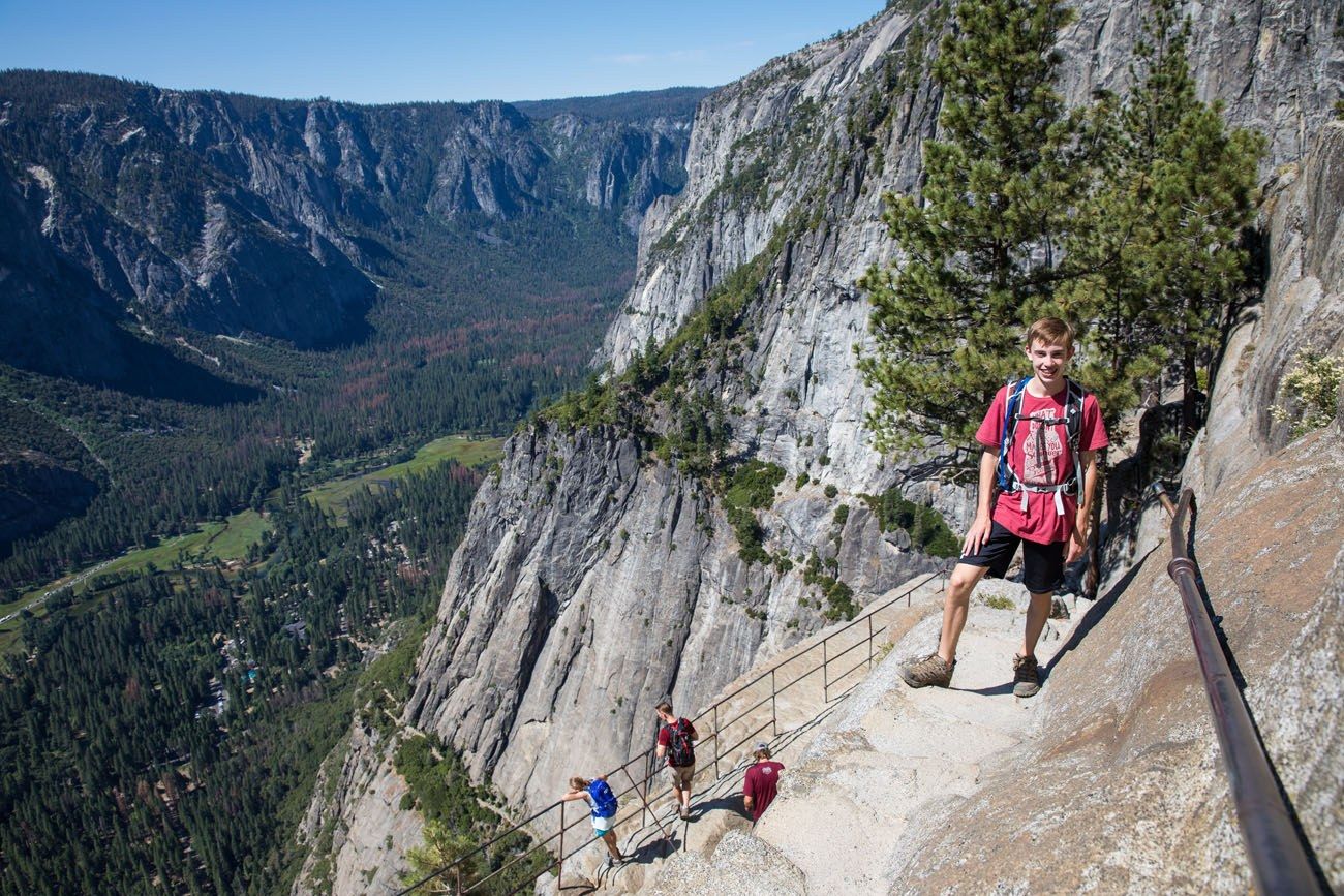
In the photo below, Tyler is standing on the final staircase down to the viewpoint. It is a narrow staircase with a drop-off on one side and a railing on the other.
A view of the falls before it cascades over the side of the cliff.
After enjoying the view, you can turn around and hike back down to the valley or continue to Yosemite Point.
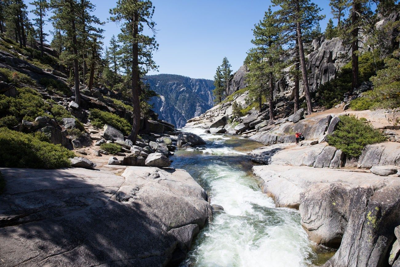
Yosemite Point
To get to Yosemite Point, it’s just over one more mile of hiking and 700 feet of climbing to go. It’s worth it.
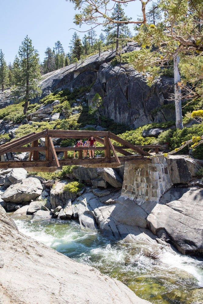
Along the way, you cross a bridge above Upper Yosemite Falls. Do not be tempted to wade in the water here. You are literally just feet away from the edge of the falls…one wrong move could be disastrous.
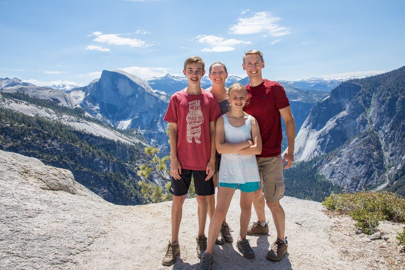
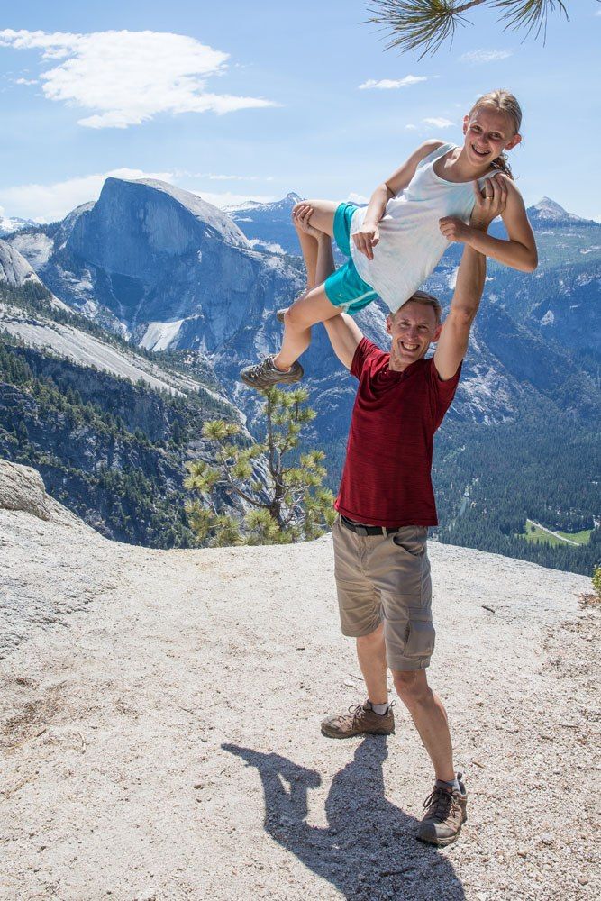
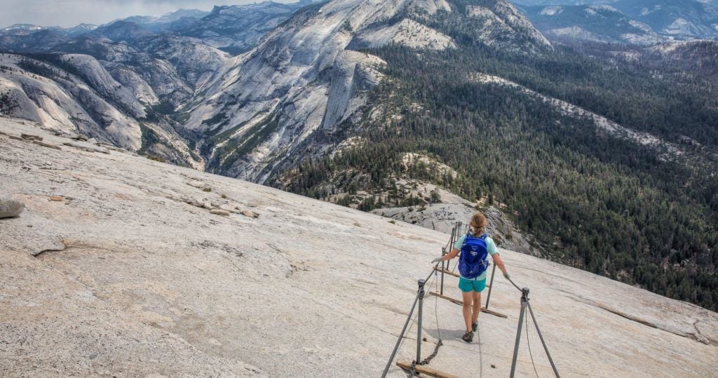
The view from Yosemite Point is simply amazing. Half Dome is just on the opposite side of the valley, a place we would be tomorrow. Yeah, doing this strenuous hike the day before the monster hike up Half Dome was a bit crazy, but we did it.
We had our chance to use the tripod that Tim lugged up the trail, perfect for a quick family photo session. The goofy ones are still our favorites.
Hiking Back to Yosemite Valley
To get back to the valley, retrace your steps back down the trail. It was a strenuous climb to get up here, but it’s almost as strenuous to get back down. Those dreaded switchbacks feel almost as difficult going down as they did going up.
And remember when I said not to underestimate this hike? We underestimated it. We failed to bring enough water for the hike, draining the last of our water halfway down the mountain. By the time we reached the bottom, all four of us were thirsty. Desperately thirsty. By now it was early afternoon, in the low 90’s, and the trail was baking in the sun.
From the trailhead, it’s just a short walk to the Yosemite Valley Lodge, where there is a cafeteria selling food and drink and lots and lots of water!
What to Bring on the Hike
Hiking Shoes. Hiking shoes are preferable, however, running shoes with good support and good traction are sufficient.
Water. The National Park Service recommends 4 liters of water per person if you plan on hiking to the top of Yosemite Falls. There is no water on the trail.
Sunscreen. There is very little shade on the mid to upper parts of the trail.
Hiking poles (optional). Hiking poles are my new favorite hiking gadget and I highly recommend them. They take about 30% of the weight off of your legs as you descend, easing knee pain and other symptoms. I use Black Diamond Distance Z poles and love them. They easily collapse down to fit in your luggage and hiking backpack, plus they are extremely lightweight. The poles come in several sizes, so make sure you pick the right length based on your height.
Hiking with Kids
At the time we did this hike, Tyler was 14 and Kara was 12. They both completed this hike easily, however, I did worry about tiring them out too much before our Half Dome hike the following day. There was no need to worry, as they both did great on the Half Dome hike.
We saw kids of all ages on this trail. An eight year old who is very active should be able to complete this entire hike. Hiking with young kids is possible, but I do not know how enjoyable this would be, especially for parents. I did see a father carrying 2 year-old at the top of the falls. He was dripping with sweat and didn’t look like he was having much fun, but it is possible.
If you are hiking with young kids and want to see Yosemite Falls, consider the hike to Columbia Rock. Enjoy the view, maybe go a little farther to feel the mist from the waterfall, and then return to Yosemite Valley. This hike is just 4 miles long and doable for most people.
Do you have any questions about hiking Upper Yosemite Falls? Comment below!
More Information for Your Trip to Yosemite
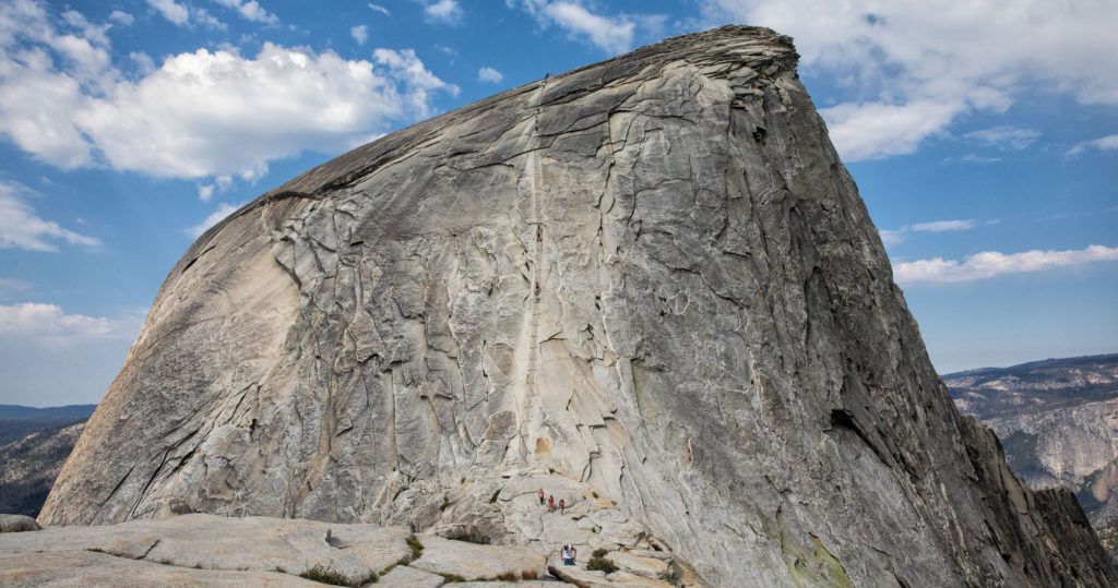
HALF DOME: Hiking Half Dome is one of the best hikes in the USA. Learn how to get your Half Dome permit and see the Half Dome cables in photos.
YOSEMITE: Check out our Yosemite National Park Travel Guide for important travel planning tips, sample itineraries, advice on when to go, where to stay, and more.
MORE GREAT HIKES IN THE NATIONAL PARKS: From hikes to the tallest peaks to beautiful coast trails, read our Guide to the Best Day Hikes in the US National Parks. If you prefer to keep your hikes short and sweet, read our guide to the Best Short Hikes in the National Parks.
USA TRAVEL INSPIRATION: For more great ideas on where to go in the United States, check out our article Best USA Road Trips, which has 18 sample itineraries for your next big adventure. You can also see more travel itineraries on our Travel Itineraries page and our National Park Itineraries.
NATIONAL PARKS: In our Guide to the US National Parks, get the full list of national parks with important travel planning information, such as things to do in the parks and sample itineraries.
Read all of our articles about California in our California Travel Guide and the USA in our United States Travel Guide.
All rights reserved © Earth Trekkers. Republishing this article and/or any of its contents (text, photography, etc.), in whole or in part, is strictly prohibited.
Comments 18
Years ago a few of us climbed this trail. I wanted a drink of water from the mountain. I was told not to but I did. There was horror on my friends faces when I did that but I have to say it was very tasty. Beautiful water. I was told that I was sure to get giardia. Nothing happened. I have drunk waters from the Swat valley in Northern Pakistan and it made me hungry. It tasted great too. Tasted like the air I was breathing there. Same experience in Yosemite.
If you have any doubt skip drinking the water. This was just my experience.
Zahid
There is a railing at Oh My Gosh Point, and the side trail is so short that no one should pass it by. It is thrilling but perfectly safe to approach and lean over the strong railing to see the best viewpoint of the entire Yosemite Falls.
Is there any way I can store some of my baggage for part or all of the day? I’ll be in Yosemite in a few days and I’d like to do the Yosemite Falls hike, but I won’t have a car so I’m carrying everything I have in a backpack. It’s pretty heavy, I’m sure it wouldn’t make this hike any easier…
Author
That’s a good question. Your best bet that I know would be at the Visitor Center. You might be able to call or email to visitor center to find out if there is a luggage storage option nearby. Cheers, Julie
Hi there,
I did this hike many years ago, so my memory is a little faded on the details. How long did it take you and your family to get to the top? The last time I did the hike, it was with a few, adult men and we left early enough to see the sunrise over the valley. I would live to do this with my family (wife and 13 year old son), but I don’t want to set us up for failure by underestimating the challenge for them.
A final question… I do remember the ledges with the handrails, but not in great detail. I’m not nervous about that sort of thing, but my wife can be. For this hike, do you recall how many areas there are where you’re on narrow trails with steep drops to the sides?
Cheers!
Author
I believe it took us about 3 hours to get to the top (Yosemite Point). We are fast hikers and we passed a lot of people on the trail. On average, I think it can take many people between 3 and 4 hours to get to Yosemite Point. The only place with the ledges and the handrails is at the optional viewpoint of Yosemite Falls. Your wife could skip this part and if I remember correctly, it might only take you 10 to 15 minutes to hike round trip to this viewpoint. For the remainder of the hike I don’t recall any other drop-offs or narrow ledges. Cheers, Julie
100% agree on not underestimating this one! We’re both pretty fit it handed our butts to us! It took us much longer than expected, and about 3/4 of the way down we ran out of h20. What a beautiful hike though, worth the output for those incredible views!!
Author
Hello Kate. It’s tough, surprisingly so. But those views are worth it…some of my favorite photos of Yosemite…and good enough to be our cover photo for our blog! 🙂 Cheers, Julie
Thanks Karen this is the best blog about yosemite yet! Did you visit Mariposa Grove at all or Sequoia National Park? If yes, do you have information about either of them and how to get from the Upper valley to them?
Author
We did not visit Mariposa Grove because it was closed during our visit. Yes, we did visit Sequoia NP, here’s the link. We drove from Mariposa to Kings Canyon and then onto Sequoia NP. Cheers, Julie
Hi, I would love to do this hike but it may be a bit more challenging than I am up for. How would you compare it to the hike to Angels Landing at Zion? More switchbacks or about the same? I turned around at Angel’s Landing before the cables because I was a scaredy cat. Up to that point the trail was challenging for me, but not too much.
Was this your favorite hike at Yosemite? We are going in 3 weeks. Thanks for any input!
Last May we followed your itinerary at Isle of Skye and had a fantastic trip!
Karen
Author
Hello Karen. I’m glad to hear you had a great trip to Isle of Skye! The hike to Yosemite Falls is considerably more challenging than Angels Landing. If you go all of the way to Yosemite Point, it is 3700 feet of climbing, more than double the elevation gain of Angels Landing. It’s also a longer hike. You could go to Columbia Rock and a little farther to a viewpoint of the waterfall. The view from Columbia Rock is wonderful. Once you get near Yosemite Falls, the more challenging hiking starts, with a lot of switchbacks and a very rocky trail. Our favorite hike in Yosemite was Half Dome, but that’s in a whole different league. If Angels Landing was a little challenging, then I think you will be fine getting to Columbia Rock. You can always go farther, and then turn around if it gets too hard. Just beyond Columbia Rock is the steepest, hardest climb of the hike, so you’ll be able to see it and test your legs. You don’t have the exposure on this trail like you do at Angels Landing, so that’s good. 🙂 Good luck! Cheers, Julie
Thanks for your reply. We will put the hike on our list and see how it goes! Thankfully (?!) Half Dome isn’t open while we will be there. And unfortunately Tioga and Glacier Point Roads will still be closed too due to all the snow they’ve had, but that means the waterfalls should be awesome which is why we’re going in May. 🙂
Karen
Author
You could hike the Mist Trail to see Vernal Fall and Nevada Fall since the waterfalls will be roaring. Just a thought. Have fun! Cheers, Julie
thank you so much for sharing this trip with the world, I was wondering if this climb would be doable for us, and our 9-year old son, now i have read this, we will try to have some exercise here in Holland before we will start the climb to the upper falls. Thanks for the detailed explanation about the hike. I think we will give it a go, and consider during the hike wether to go all the way or just to colombia rock. It has been very helpfull. Thanks a Lot!!
Author
You’re welcome! We did see a lot of young kids on this trail. Like you said, just go as far as you feel comfortable. It’s a very nice view from Columbia rock. Cheers, Julie
Hello,
I just came across your blog post and it has been so helpful. Myself, brother, and boyfriend are going to be doing this hike at the end of March. This will be our most challenging hike yet. I was wondering what time you started the hike and about what time you finished? I was also wondering the type of lunch and snacks you brought along?
Thank you so much!
-JT
Author
We started the hike around 7:30 am and it took us about 6 hours, so we finished around 1:30 pm. We eat energy bars (we love Kind Bars and Lara bars), salty snacks like pretzels and beef jerky, dried fruit, nuts, and cookies. We don’t always eat all of that, but those are the things that usually make it into our hiking backpacks. Plan to bring at least 2 liters of water per person, and bring more than this if the day time high will be over 60 degrees Fahrenheit. Even in March, with that uphill walk, you can sweat a lot. Have fun…the views are amazing! Cheers, Julie