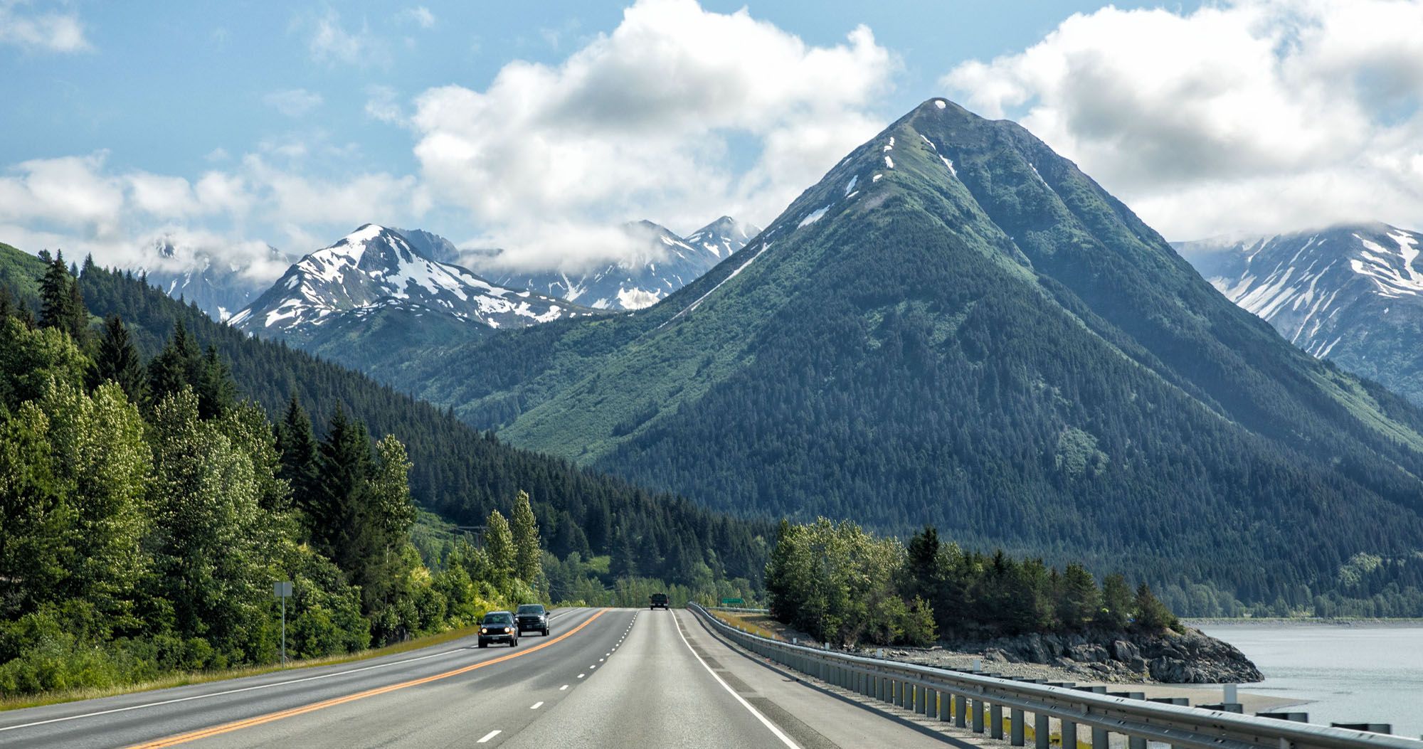
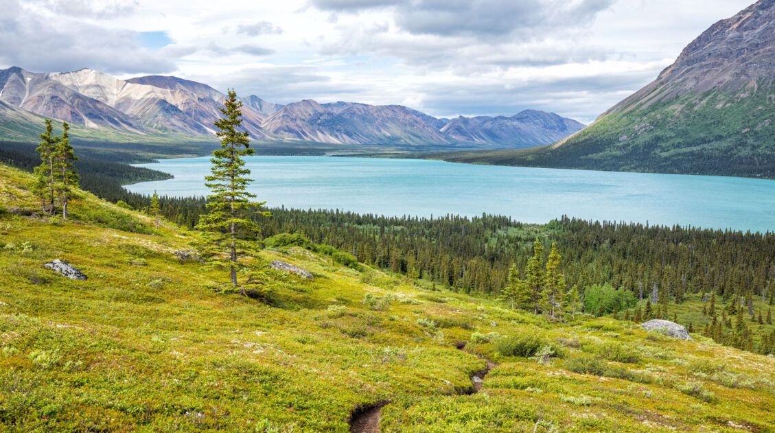
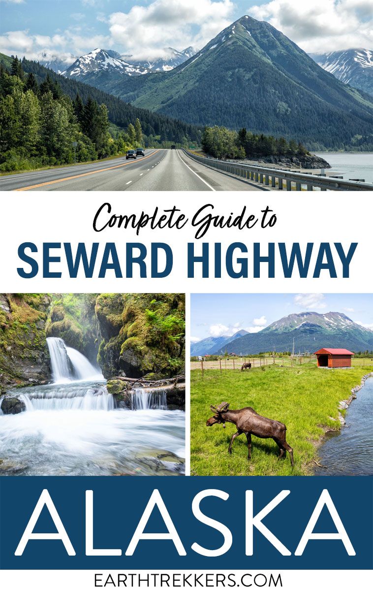
The drive from Anchorage to Seward on Seward Highway is beautiful, an attraction in itself. Along the way you can gaze across the Turnagain Arm, ride a cable car up into the Chugach Mountains, admire beautiful turquoise lakes with mountain reflections in them, hike to a waterfall in a picturesque setting, and so much more.
There are so many things to do that you’ll need to be selective and manage your time accordingly. Therefore, I provide time estimates for each stop. And at the end of the article I list our top experiences.
Okay, we have a lot to cover, so let’s get started …
Overview of the Drive
Distance: The Seward Highway stretches 125 miles between Anchorage and Seward. Detours to some of the things to do along the way will add additional mileage.
Length of Time: 2 hours and 15 minutes without any stops. With stops, this can take a full day.
Route: There is only one way to do this drive. From Anchorage, take Alaska Route 1 (AK-1, also called Seward Highway) to the junction at Tern Lake (near Moose Pass). From the junction at Tern Lake, take Alaska Route 9 (AK-9, also called Seward Highway) towards Seward. You read that correctly, the route number changes but the name of the highway stays the same.
When to Go: You can do this drive all year. Use the following map to check road conditions before you start your journey, especially during the winter months. The Alaska Department of Transportation also provides the following safety tips for winter driving.
Type of Vehicle: All of the roads are paved, so in the summer a regular car is just fine for this drive. Outside of the summer season make sure your vehicle is prepared for winter conditions. The Alaska Department of Transportation provides the following vehicle preparation tips for winter driving.
Going from Seward to Anchorage: If you plan to do this drive in the opposite direction, you can still use this guide. Just simply follow it in reverse.
Alternate Options to travel between Anchorage and Seward: You can take the Coastal Classic train route offered by the Alaska Railroad. Or you can take the Seward Express bus route offered by The Park Connection. You can also look for an air taxi service that offers flights between Anchorage and Seward.
How to Use This Map: Click the tab in the top left corner of the map to see a list of the points of interest and to turn layers on/off. Click the icons on the map to get more information about each point of interest.
To take this map with you, click the star next to the title of the map which adds it to your Google account. Next, within your Google Maps app, select ‘Saved’ and then select ‘Maps’. This map title will now appear in your list.
Things to Do along Seward Highway
This list starts in Anchorage and ends in Seward. It’s a very long list and you will not be able to do everything in one day. So, I recommend picking out your favorite stops. You can see things you skip (or run out of time for) when you drive back to Anchorage.
In addition, I mention Seward and the Exit Glacier area of Kenai Fjords National Park at the end of the list. Its best to add additional time into your itinerary for these places.
All directions are provided as if you are driving from Anchorage to Seward. When I did our research before our trip the locations of these stops were referenced by the mileposts along the Seward Highway. But I rarely saw mileposts when doing this drive. Therefore, I provide the mileage between each stop so you can keep track using the odometer in your vehicle. You can also refer to the map above which marks the location of each of these sights.
Anchorage
I recommend filling up your vehicle with gas before starting this drive. In between Anchorage and Seward the only gas station we saw was in Girdwood, at the intersection of Seward Highway and Alyeska Highway.
I also recommend stopping at a grocery store in Anchorage to pick up snacks to have on hand when making this drive. Otherwise, you’ll have to wait until Girdwood or Whittier to get any food.
If you plan to do any hiking while you are in Alaska, then it’s a good idea to go to the REI in Anchorage and purchase bear spray.
Potter Marsh Wildlife Viewing Boardwalk
It doesn’t take long until you reach the first attraction along the Seward Highway. The Potter Marsh Wildlife Viewing Boardwalk (aka Potter Marsh Bird Sanctuary) is located just outside of Anchorage. There is a half mile long boardwalk elevated over the marsh, which offers the opportunity to see moose, muskrats, a variety of birds including eagles, and more. See the following website for details on the type of wildlife for different times of the year.
We questioned this stop since it is so close to Anchorage and one of the boardwalks runs right alongside the Seward Highway. But people love it. There is another boardwalk that runs deeper into the Marsh (away from the highway) and moose are frequently spotted. And someone local to Anchorage told us that moose feel safer from predators by staying close to Anchorage.
HOW TO GET TO POTTER MARSH: From the Seward Highway turn left onto E 154th Ave and then make an immediate right. The road will dead end at the parking lot.
PLANNING YOUR TIME: Allow 1 hour to walk the boardwalks and look for wildlife.
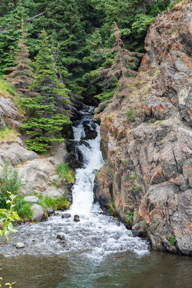
McHugh Creek Day Use Area
There are hiking trails here but for first-time visitors driving from Anchorage to Seward in one day, this stop is generally more about seeing a waterfall and a view out over Turnagain Arm, the body of water on the opposite side of the Seward Highway.
From the lower parking lot, you can walk halfway back towards the entrance to see the waterfall. A short walk up the stairs connects the lower and upper parking areas (or you can drive between the two). Once there you have a view out over Turnagain Arm.
View of Turnagain Arm from the upper parking lot.
View McHugh Creek from one of the paths in the McHugh Day Use Area.
HOW TO GET TO MCHUGH CREEK DAY USE AREA: From the exit for Potter Marsh (E154th Ave) drive 5.9 miles along the Seward Highway and turn left into the McHugh Creek parking lot. There is a sign for “McHugh Creek” just before you turn into the parking lot.
PLANNING YOUR TIME: Allow 30 minutes to see the waterfall and to walk to the upper parking lot for the view and then back down.
Beluga Point
This viewpoint provides great panoramic views of the Turnagain Arm with a mountainous backdrop. This is also a popular spot for whale watching.
Seward Highway continues alongside Turnagain Arm and there will be many viewpoints along the way where you can stop and look out across Turnagain Arm and the mountain peaks behind it. Many of these viewpoints offer a similar view but from a slightly different angle. So, we recommend picking a couple to stop at rather than trying to stop at all of them. We particularly liked Beluga Point Site and Bird Point so we’ve listed both of them in this article.
CAUTION: The beaches along the Turnagain Arm are made up of mudflats, which can act as quicksand and put you in a dangerous situation when the tide rises. Don’t try to walk along the shore of the Turnagain Arm. Instead, enjoy the beauty of the Turnagain Arm shoreline from the viewpoints.
HOW TO GET TO BELUGA POINT: The Beluga Point Site is located on the right side of Seward Highway 1.4 miles from the entrance to the McHugh Creek Day Use Area. Look for a sign that reads “Beluga Point” as you approach.
PLANNING YOUR TIME: This stop can be quick if you just want to see the views from the parking area. Otherwise, allow 30 minutes to walk out onto the rocky hill for unobstructed views of Turnagain Arm in both directions.
Dall Sheep
Dall Sheep are one of Alaska’s “Big Five”, along with bear, moose, caribou, and wolves. They can often be spotted along the Seward Highway clinging to the sides of mountains. A great spot to look for them is along the cliffs on the left as you drive between Beluga Point and Bird Point.
Allow 15 minutes to pull off the road and watch the Dall Sheep if you spot them.
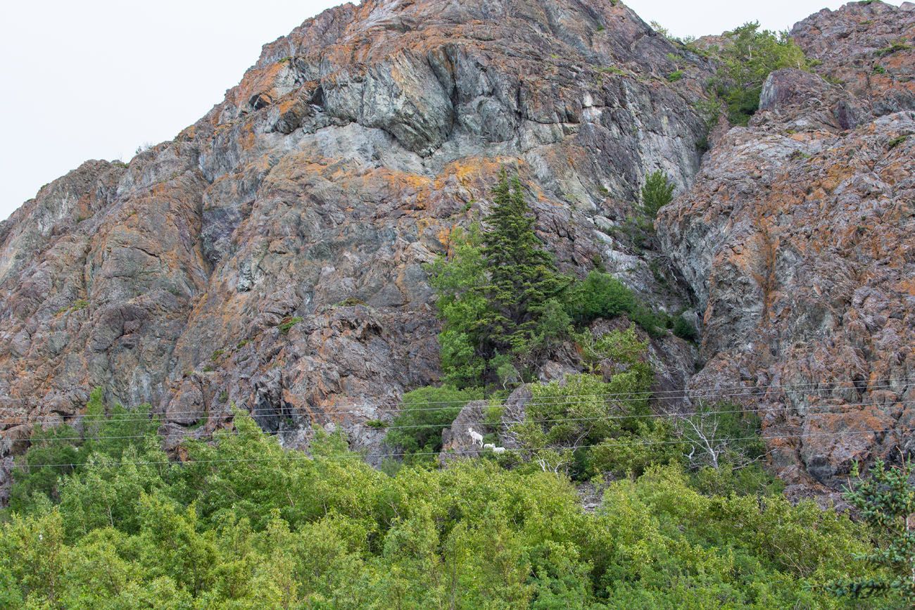
The Dall Sheep can be hard to spot. Can you see them just above the tree line?
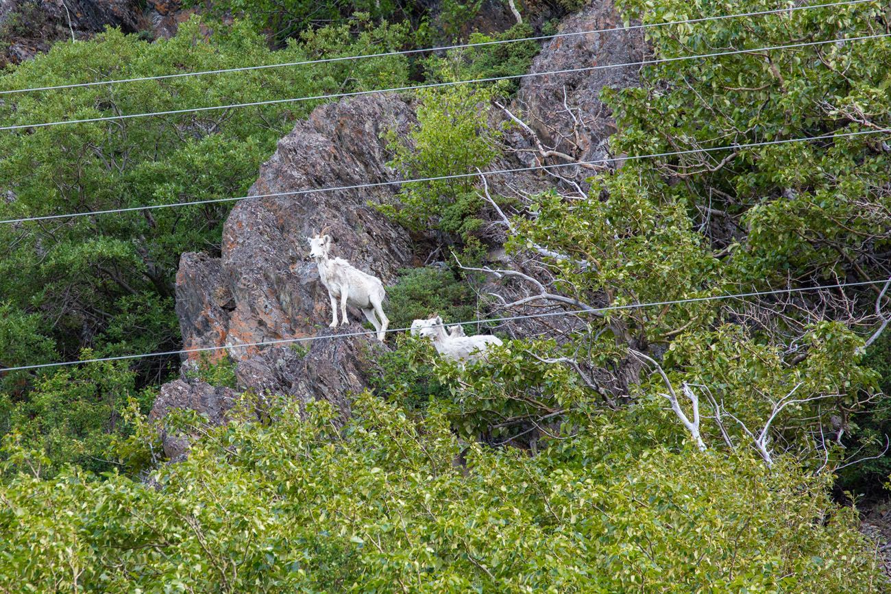
A closer view of the Dall sheep.
Bird Point
We especially liked the view of Turnagain Arm from Bird Point. There was just something about seeing Turnagain Arm with the mountains in the background and the treetops in the foreground.
This is also a popular spot for viewing a tidal bore. A tidal bore is a wave of water that travels up a body of water against the current. The Turnagain Arm is one of only a few places in the world where this phenomenon occurs. The breaking wave stretches across the Turnagain Arm and its height can vary from 6 inches to 6 feet. Signage at this viewpoint provides more information on tidal bores.
Seeing this phenomenon requires some advance planning as you need to be at Bird Point 2 hours and 15 minutes after low tide in Anchorage. While it occurs twice daily you can’t wait too long to see this if you want to make more stops along the Seward Highway.
HOW TO GET TO BIRD POINT: 13.5 miles from Beluga Point is the turnoff for Bird Point. You’ll turn right off of Seward Highway at the posted sign and then follow the road to the parking area. There is a small fee to park here so look for the pay machine as you enter the parking lot. Follow the ramps up to the viewpoints.
PLANNING YOUR TIME: Allow 30 minutes to walk the ramps to the various viewpoints and to enjoy the view.
Girdwood
Girdwood is a small town located just off the Seward Highway. It sits in a valley surrounded by the Chugach Mountains and several glaciers. Here you can enjoy the magnificent view from the Glacier Creek Bridge, stretch your legs on a short hike to a waterfall, and ride the cable car up Mt Alyeska.
Glacier Creek Bridge Viewpoint
From the bridge you get a beautiful view of Glacier Creek with the mountains in the distance.
HOW TO GET TO GLACIER CREEK BRIDGE: From the intersection of Seward Highway and the Bird Point turnoff, travel 6.4 miles along Seward Highway and turn left onto Alyeska Highway. Follow Alyeska Highway 2.3 miles until you reach the bridge.
There isn’t any parking at the bridge itself, so you’ll need to park just before reaching the bridge. About a tenth of a mile before the bridge turn left onto Hightower Road. Then make an immediate left onto Girdwood Place and look for a place to park. From here it is a short walk to the bridge. There is a sidewalk along Alyeska Highway that you can follow that will lead to the pedestrian portion of the bridge.
PLANNING YOUR TIME: The drive from Seward Highway is less than 5 minutes. Allow another 15 minutes to walk to/from the bridge and to enjoy the view.
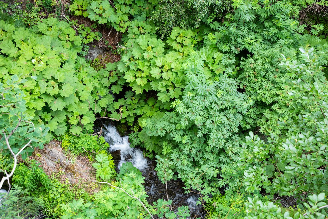
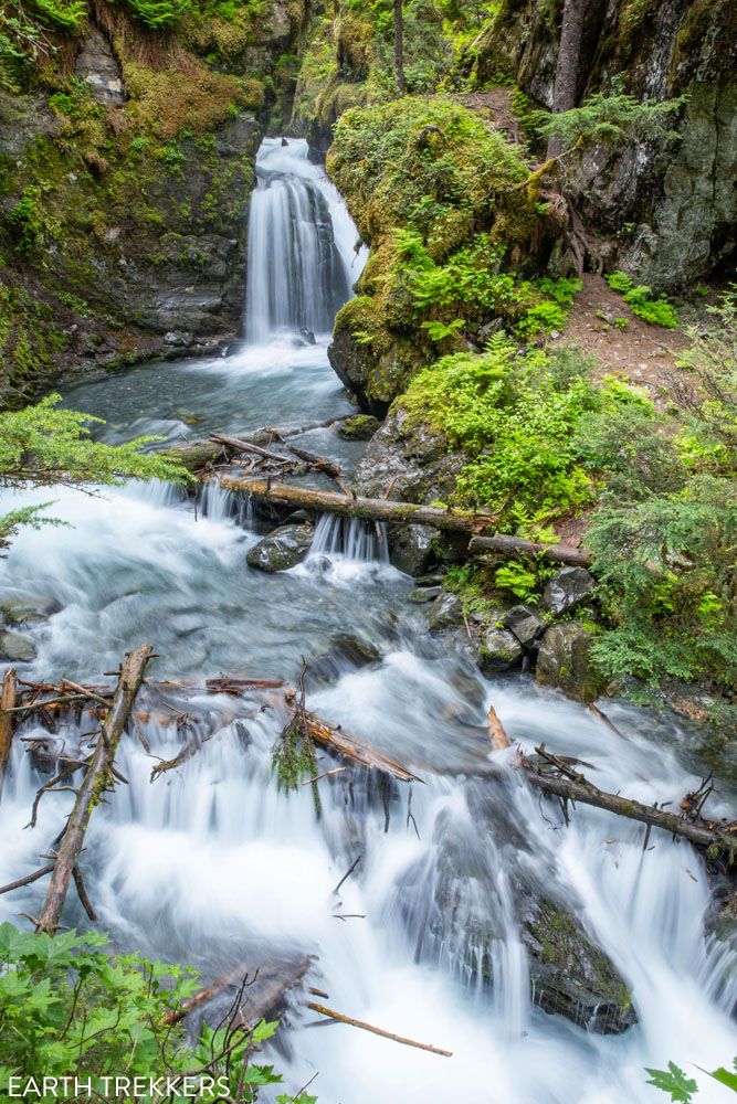
Virgin Creek Waterfalls
This is a short, fun hike to a beautiful waterfall. The Virgin Creek waterfalls are lined with enormous trees and mossy rocks, which add to the natural setting.
The trailhead is at the end of Timberline Drive. Once on the trail, you will hike along the Virgin Creek, crossing over lots of large tree roots. Enjoy the view of the first waterfall and then continue up the trail to the second waterfall. Overall, it is only a half a mile hike roundtrip.
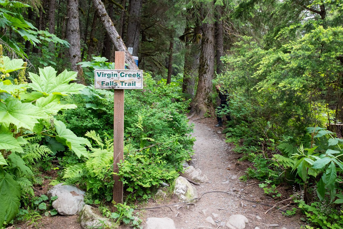
HOW TO GET TO VIRGIN CREEK WATERFALLS TRAILHEAD: From Glacier Creek Bridge follow Alyeska Highway another 0.3 miles and turn right onto Timberline Drive. Follow Timberline Drive to the very end (it will be about 1.1 miles).
CAUTION: Timberline Drive goes through a residential community so please drive slowly and be respectful of the people that live here and the kids at play.
PLANNING YOUR TIME: Allow 45 minutes overall: 15 minutes to drive slowly in and out of the neighborhood and 30 minutes to hike the trail.
Alyeska Aerial Tram
The Alyeska Aerial Tram will take you up Mt. Alyeska for scenic views overlooking Girdwood, the surrounding Chugach Mountains, and a portion of Turnagain Arm. From the viewing platform you can have lunch and visit the Roundhouse Museum and Gift Shop.
There are many summer and winter activities at this resort, but if you are driving the Seward Highway in one day, then you will have to limit your time to just enjoying the view from the aerial tram and platform, visiting the Roundhouse, and eating a quick lunch. The lunch at the viewing platform was surprisingly good.
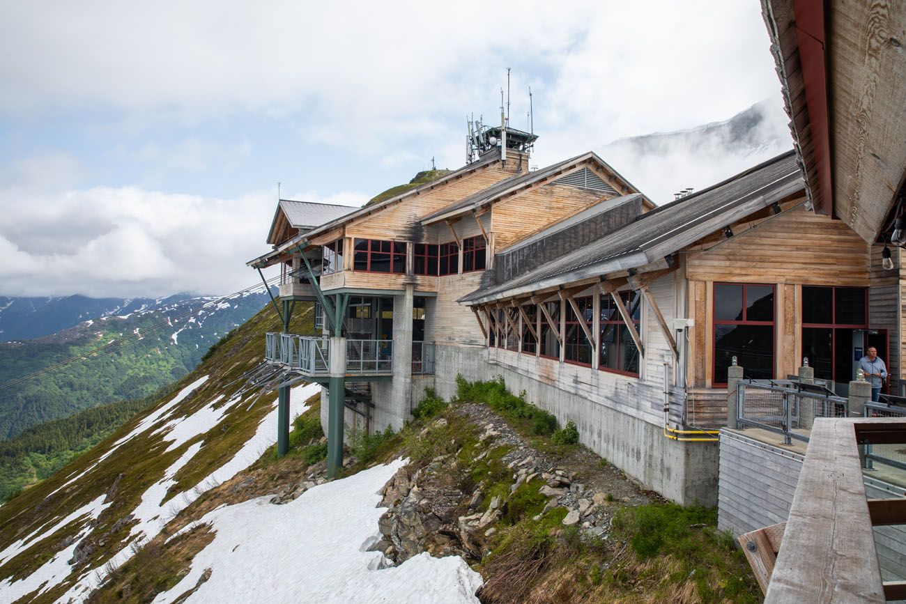
The speed of the tram is slower in the summer months so passengers have more time to enjoy the views and look for moose and bear in the foliage below. They speed up the tram in the winter to whisk skiers up the mountain quickly.
During the summer the aerial tramway departs once the gondola is full or every 15 minutes, whichever occurs first.
There is a now a new experience at Alyeska Resort. Called the Veilbreaker Skybridges, you will hike through the mountain peaks, crossing two suspension bridges. This guided experience takes 2 to 3 hours and you must arrive an hour before your tour starts. It’s something to consider if you like the idea of hiking, alpine views, and aren’t afraid of heights, and have about a half day of free time. Learn more here.
HOW TO GET TO ALYESKA AERIAL TRAM: Follow the Alyeska Highway until it dead ends (0.3 miles past Timberline Drive). Turn left onto Arlberg Avenue and follow it 1 mile until you reach the Alyeska Resort and Hotel. Park here and the Alyeska Aerial Tram is behind the resort.
COST: Get updated prices here.
PLANNING YOUR TIME: Allow 2 hours to ride the tram, visit the Roundhouse, and to have lunch.
Alaska Wildlife Conservation Center
The Alaska Wildlife Conservation Center is a sanctuary dedicated to preserving Alaska’s wildlife. They take in orphaned and injured animals and provide them with the care they need. They also conduct a variety of research and education activities to support their conservation efforts.
Visitors can walk or self-drive the 1.5-mile loop to see moose, bear, reindeer, wolves, muskox, bison, caribou, and more in their enclosures. Walking does offer the best experience.
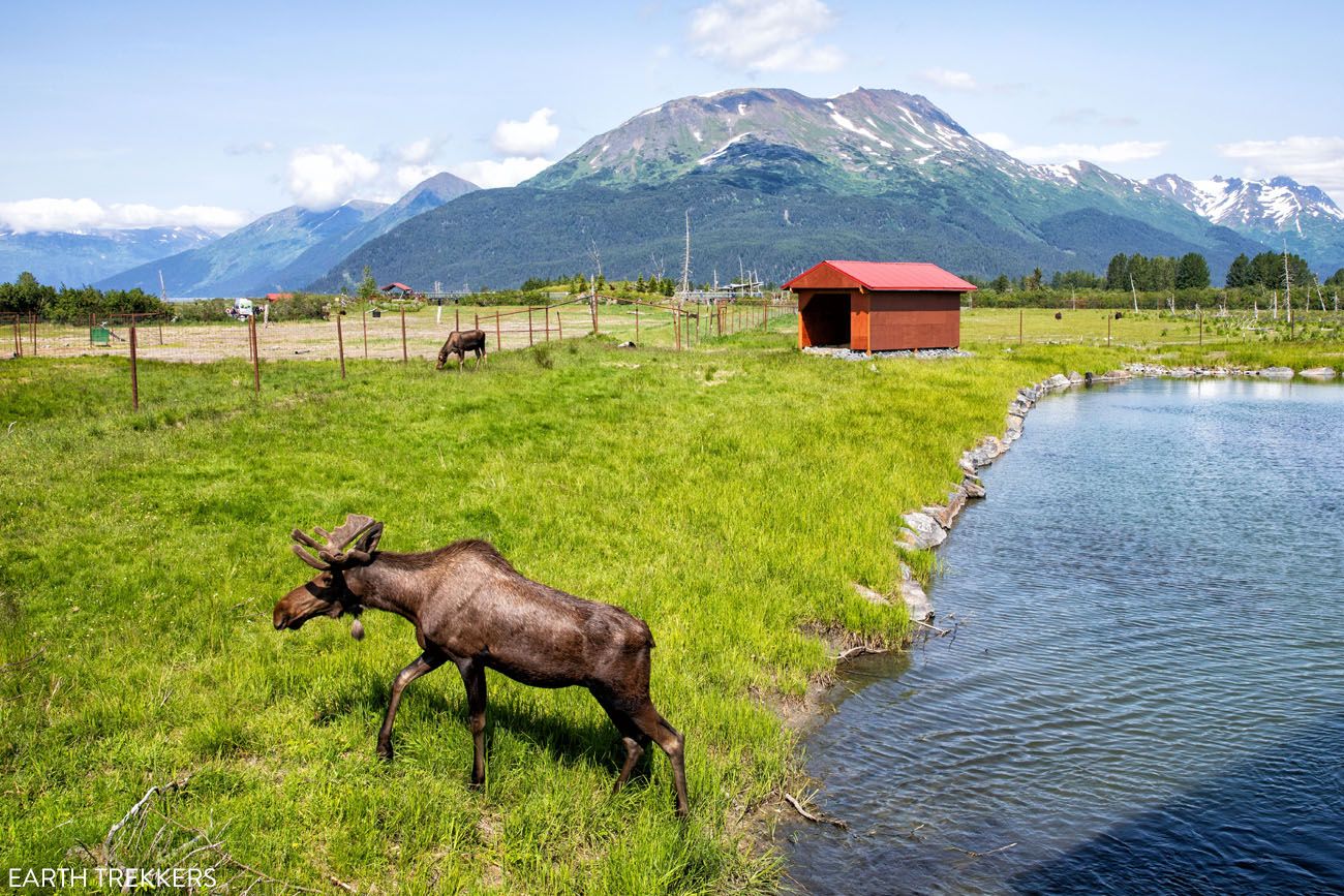
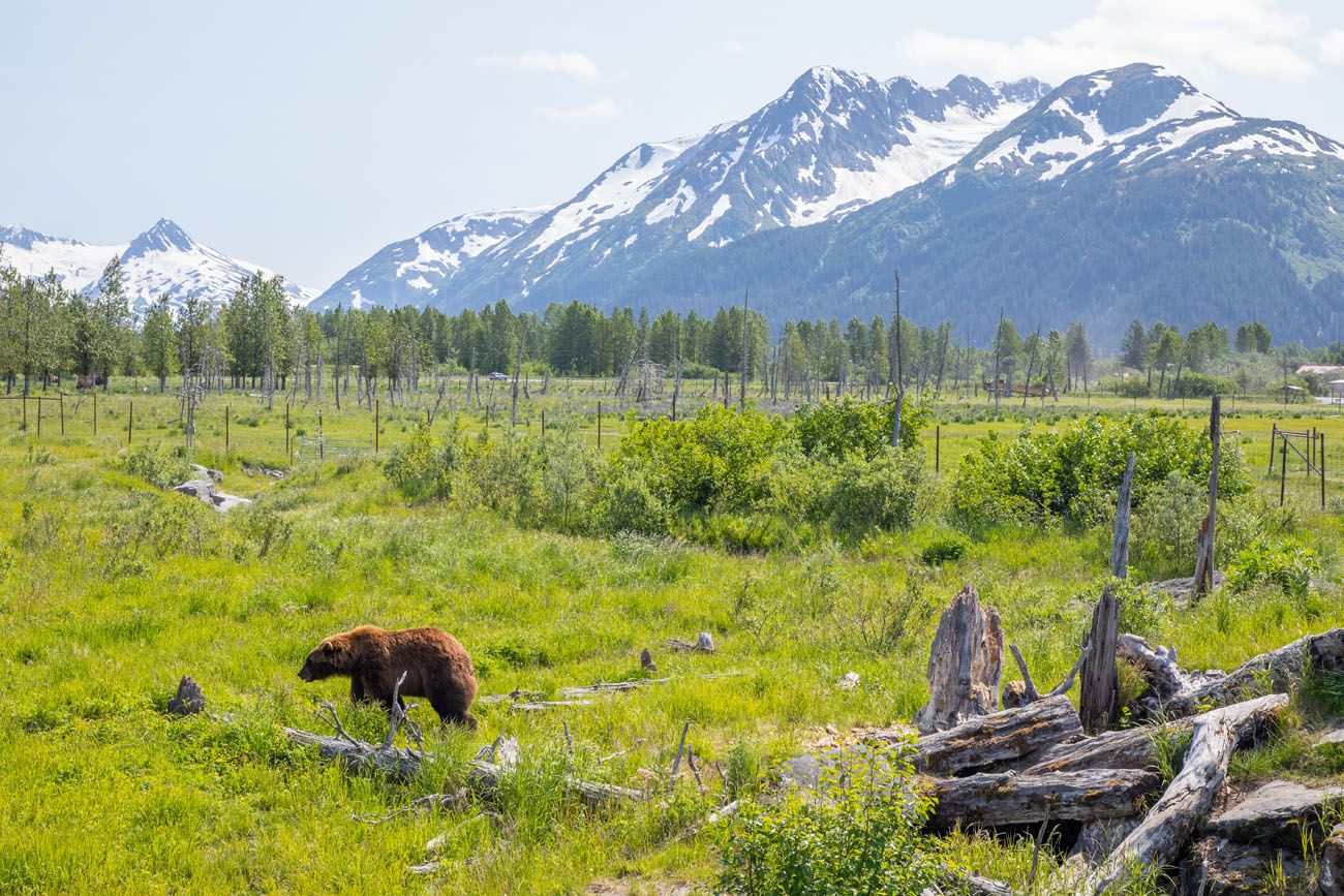
I encourage everyone to stop here, even adventure seekers who would rather spot these animals in the wild, as the price of admission is helping to support their conservation efforts.
HOW TO GET TO THE ALASKA WILDLIFE CONSERVATION CENTER: From the intersection of Alyeska Highway and Seward Highway, follow Seward Highway 10.9 miles and turn right into the Alaska Wildlife Conversation Center. There is a posted sign just before the entrance.
COST: Get updated pricing here.
PLANNING YOUR TIME: Allow 2 hours. We walked around fairly quickly and it took us an hour to visit most of the enclosures. You could easily spend another hour here (especially if you are travelling with children) watching and admiring the wildlife at a slower pace.
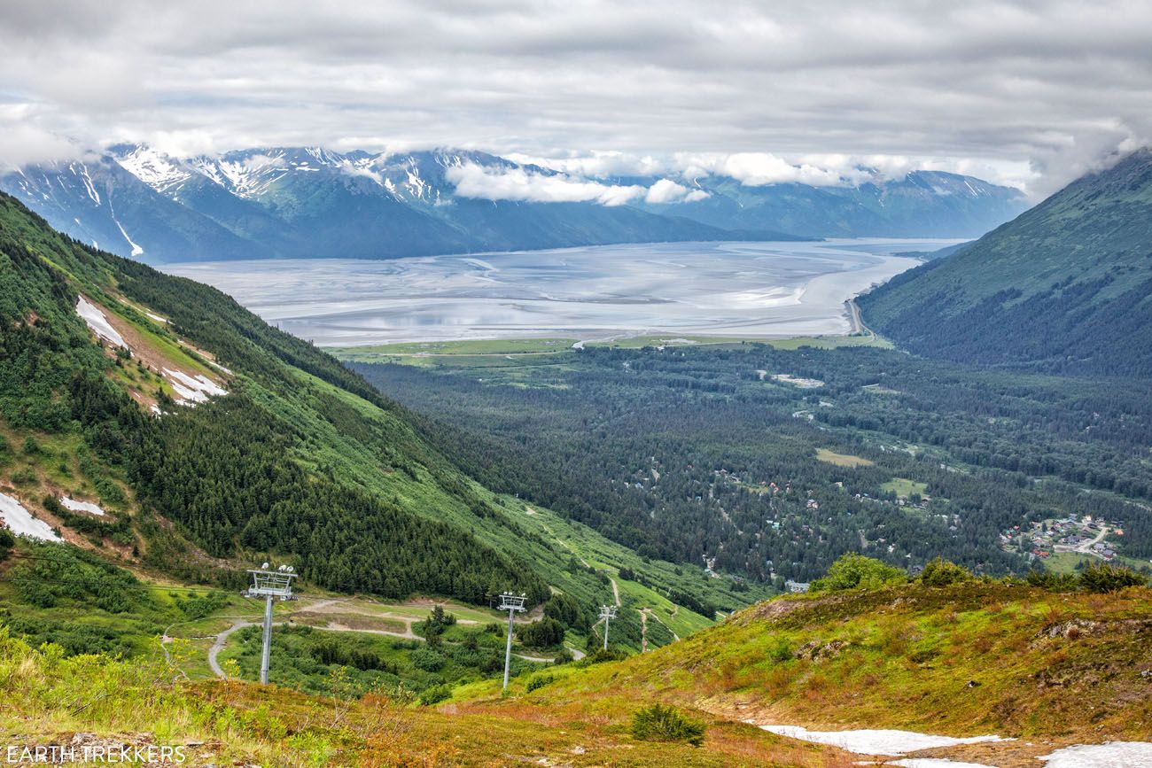
Portage Lake
There are various attractions in the Portage Lake area. The main attraction is Portage Lake, which you can see from the Portage Lake Overlook. At the Begich Boggs Visitor Center you can learn about Chugach National Forest and the ecosystems of Portage Valley and Prince William Sound. There are hiking trails in this area. And you can join Portage Glacier Cruises for a one-hour cruise to the Portage Glacier face with the possibility of seeing calving events.
But if you are traveling the Seward Highway in one day, then I recommend limiting your time to just the Portage Lake Overlook. You will not be able to see the face (terminus) of Portage Glacier but the view from here is still spectacular.
Portage Lake Overlook
Portage Lake is an amazingly beautiful turquoise blue lake with a scenic mountain backdrop.
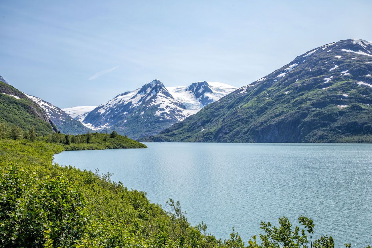
HOW TO GET TO THE PORTAGE LAKE OVERLOOK: To reach the overlook from the Alaska Wildlife Conservation Center, drive another 0.4 miles along Seward Highway. Then turn left onto Portage Glacier Road. After about 5.4 miles along Portage Glacier Road you will reach Portage Lake. Keep following Portage Glacier Road another 0.7 miles to the other side of the lake. There will be a parking area on the right immediately past the lake.
PLANNING YOUR TIME: Allow 30 minutes overall: 10 minutes for the drive in each direction and 10 minutes to enjoy the view.
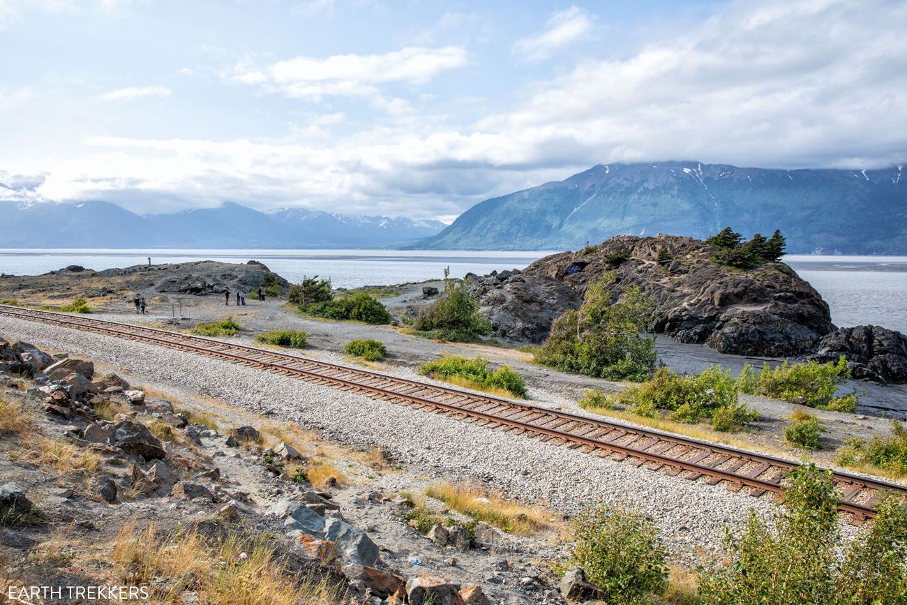
Whittier and the Anton Anderson Memorial Tunnel
Whittier is often referred to as the Gateway to Prince William Sound. Popular things to do include hiking the Portage Pass Trail, taking a glacier cruise, kayaking, enjoying the restaurants and shops around the scenic harbor area, and more.
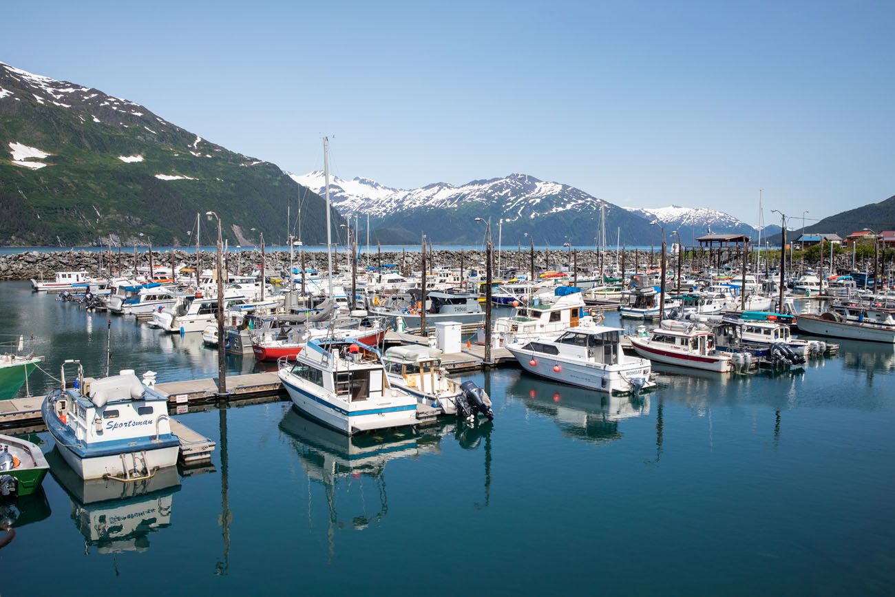
Whittier harbor
To get to Whittier from Portage Lake you have to drive through the Anton Anderson Memorial Tunnel. The pay station for the tunnel is about a quarter of a mile further down Portage Glacier Road beyond the Portage Lake Overlook.
The tunnel is 2.5 miles long, is only wide enough for one way traffic, and has railroad tracks running down the middle. Since it is a one lane tunnel, motor vehicle traffic and train traffic in each direction is coordinated. In the summer, the tunnel opens to motor vehicle traffic heading towards Whittier at the bottom of the hour and it opens to motor vehicle traffic departing Whittier at the top of the hour.
Check the Anton Anderson Memorial Tunnel website for more details on operating hours, tolls for various vehicle types and trailers, size restrictions, etc. There is also a new ticketing system where you can purchase your tickets online.
The main harbor area of Whittier is just a little more than a mile beyond the tunnel.
Due to the operational schedule of the one lane tunnel it is tough to fit Whittier into your schedule when trying to drive the Seward Highway from Anchorage to Seward in one day. If your timing is good then in 1 hour you could pass through the tunnel, see the harbor very quickly, and then get back in line to pass back through the tunnel. Doing anything more than that then you will be adding 1 hour increments onto your schedule before you can pass back through the tunnel.
Therefore, consider spending a night in Whittier in order to hike the Portage Pass Trail, to take the 26 Glacier Cruise offered by Phillips Cruises, and more.
Kenai Welcome Sign
The “Welcome to Alaska’s Kenai Peninsula” sign is located 3.9 miles further along the Seward Highway from the intersection of Seward Highway and Portage Glacier Road. When the road makes a wide 90 degree turn to the left, start looking for the sign on your right. You can see it from the road. There is a pull off at the sign for those who want to stop and take photos.
Allow 5 to 10 minutes if you want to stop and take photos.
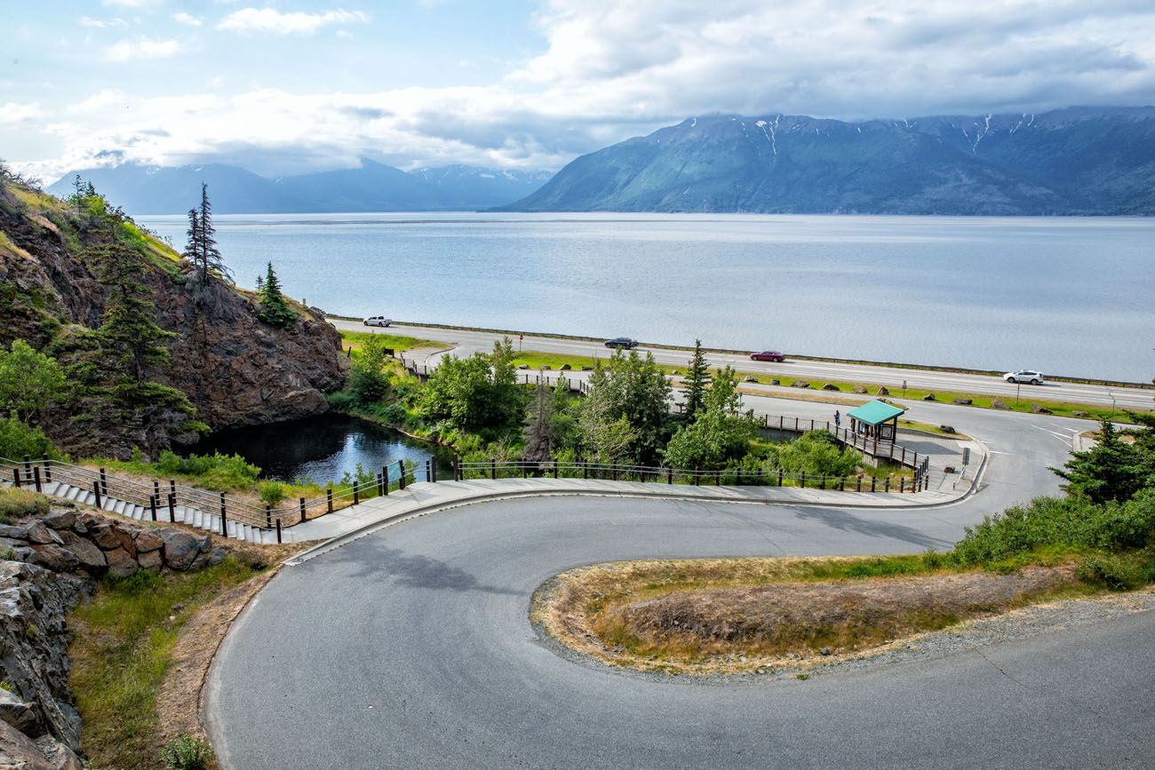
Turnagain Pass
From the Kenai Welcome Sign, the Seward Highway will now ascend about 900 feet to the top of Turnagain Pass, which is the highest point along the Seward Highway.
There is a parking area at the summit if you want to stretch your legs and take photos of the surrounding scenery. Otherwise continue onward and enjoy the mountain views as you are driving.
Allow 15 to 30 minutes is you want to stop. We just enjoyed the views without stopping.
As you continue along the Seward Highway you will pass Canyon Creek Rest Area, which we think is a skippable stop.
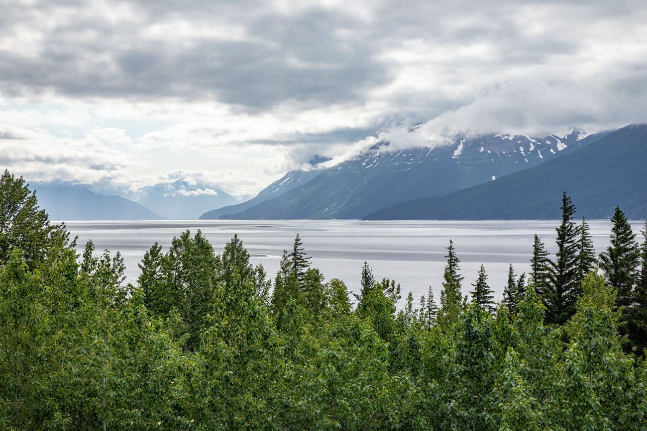
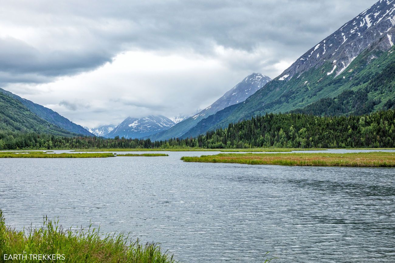
From here, and pretty much the rest of the way to Seward, you’ll pass a lot of roadside lakes: Summit Lake, Tern Lake, Trail Lakes, Kenai Lake, Lily Pad Lake, and Bear Lake. Most of these lakes have pull outs so you can stop for photos if the scenery catches your eye. Our favorite and the one we recommend stopping at is Tern Lake.
Tern Lake
Tern Lake is a beautiful lake setting with a mountainous backdrop.
HOW TO GET TO TERN LAKE: Tern Lake is located just beyond the Seward Highway and Sterling Highway split. Sterling Highway splits off to the right and becomes Route 1. Seward Highway continues straight and becomes Route 9. Keep straight at the split to stay on Seward Highway (now Route 9). There is a pull off on the right side of the road 0.4 miles past the split. Pull in here for a view across Tern Lake.
There may be trees obscuring your view so to get a better view, continue on Seward Highway another tenth of a mile and turn right onto the intersecting road. Then turn left into the Tern Lake Pullover.
PLANNING YOUR TIME: Allow 15 minutes to stop and take photos.
Moose Pass
Moose Pass is a very small town along the Seward Highway. It has a great name but there isn’t much to do here. There is a grocery store, lodge, restaurant, campground, a trading post, and a small community.
We recommend stopping at the Moose Drop-In Trading Post. This is a quirky little shop with a talking moose, really amazing fudge, and more. If you pick up some fudge on your way to Seward, then you will likely stop here again on your way back towards Anchorage. The fudge is that good…you have been warned!
HOW TO GET TO MOOSE DROP-IN TRADING POST: From Tern Lake continue on Seward Highway (Alaska Route 9) for 7.7 miles. Moose Drop-In Trading Post will be on the right side of the road with a small parking area in front of the store.
PLANNING YOUR TIME: Allow 30 minutes.
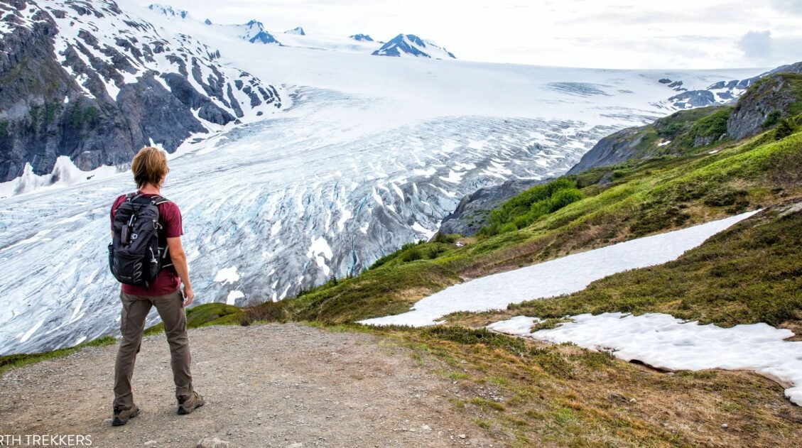
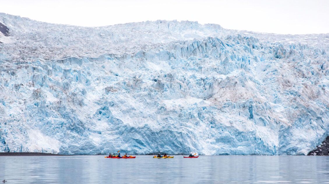
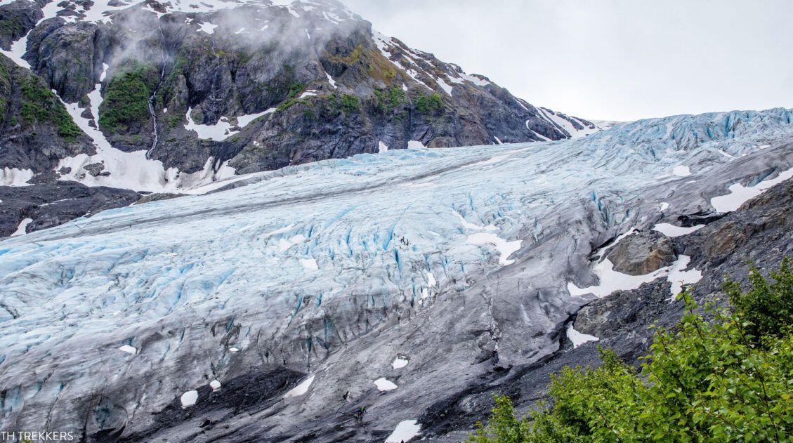
Kenai Fjords National Park: Exit Glacier Area
The Exit Glacier was named after a 1968 expedition that crossed the Harding Icefield and they used this glacier as their “exit” point. It is the most accessible glacier in Kenai Fjords National Park because Herman Leirer Road (aka Exit Glacier Road), the only road in Kenai Fjords National Park, goes right to it.
In the Exit Glacier area, you can see the Kenai Fjords National Park sign and you can see the Exit Glacier from the road. There are also hiking trails that will take you closer to the Exit Glacier terminus and to the top of the Exit Glacier so you can look out across the Harding Icefield. You can even participate in an excursion on the glacier such as glacier hiking or ice climbing.
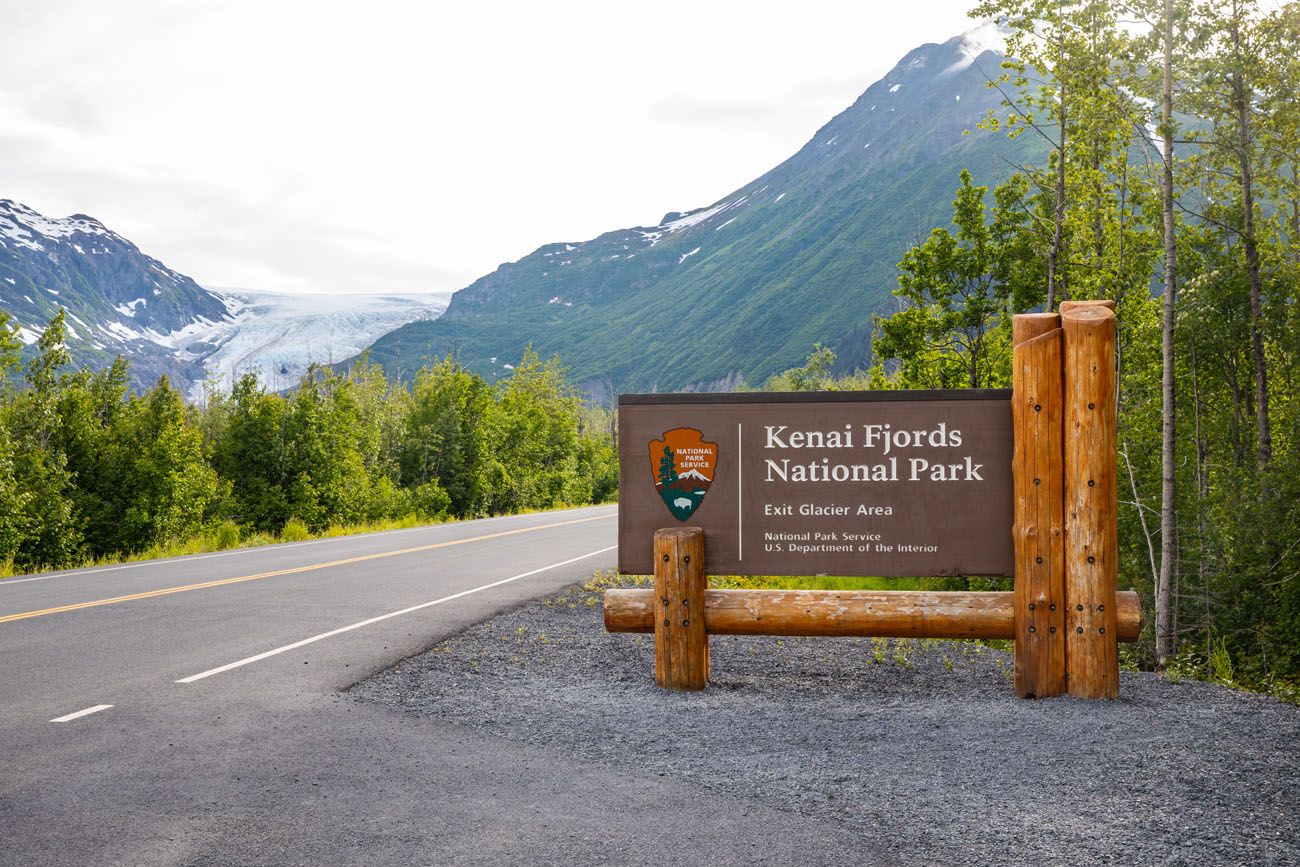
HOW TO GET TO EXIT GLACIER: From Moose Pass continue along the Seward Highway for 24.8 miles and turn right onto Herman Leirer Road (aka Exit Glacier Road). Then follow Herman Leirer Road about 8.5 miles until it dead ends at the parking lot.
As you drive down Herman Leirer Road, you will see the Kenai Fjords National Park entrance sign and you will also see signs with four-digit numbers on them. These signs mark prior locations of the Exit Glacier terminus and the numbers reflect the year the terminus was at that location. It is worrisome to see how much the Exit Glacier has retreated, which is largely believed to be a result of climate change.
PLANNING YOUR TIME: Allow 1 hour to see the Kenai Fjords National Park sign and to see the Exit Glacier from the road. More time will be needed to hike or to participate in an excursion on the glacier so it would be best to save those activities for a different day.
Seward
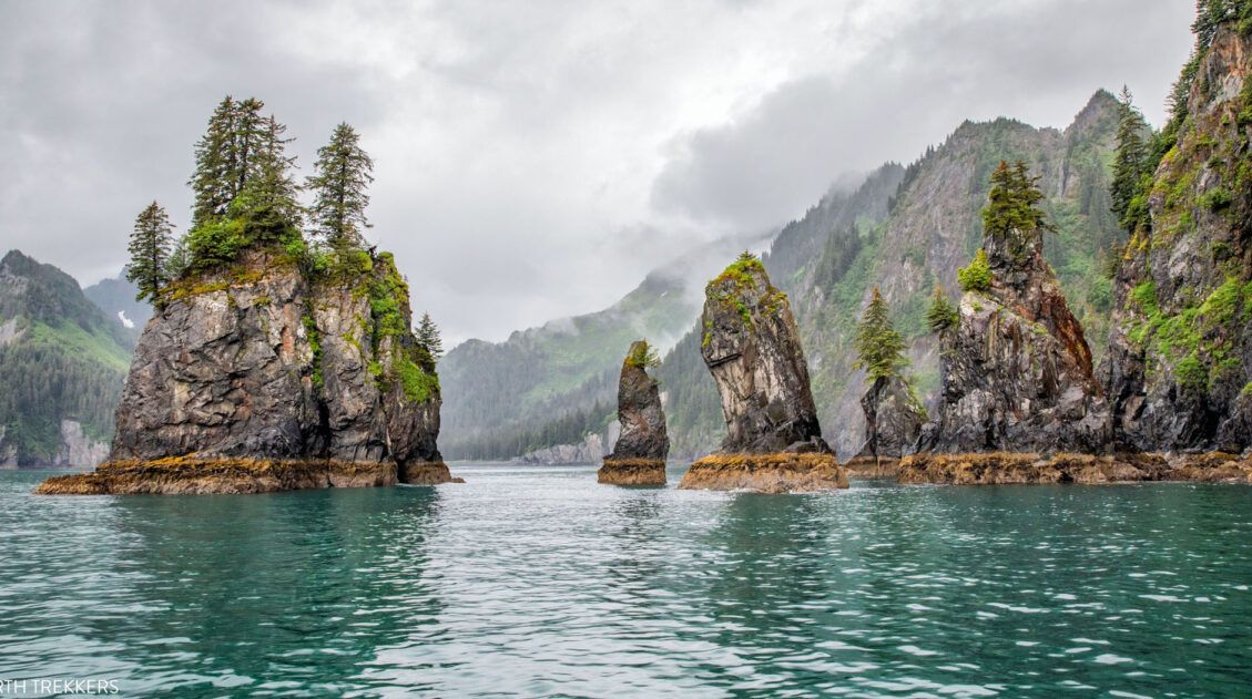
Seward is a small city located at the end of the Seward Highway and on the northern end of Resurrection Bay. This is where most people stay when exploring Kenai Fjords National Park. Boat excursions leave from the harbor and take passengers into the coastal fjords of Kenai Fjords National Park. Along the way passengers look for wildlife (whales, otters, seals, sea lions, puffins, eagles, and more) and see glaciers.
In town, you can hike to the top of Mount Marathon which serves as the backdrop of the town. You can also see animals such as puffins at the Alaska SeaLife Center, dine in the restaurants, go shopping, and much more.
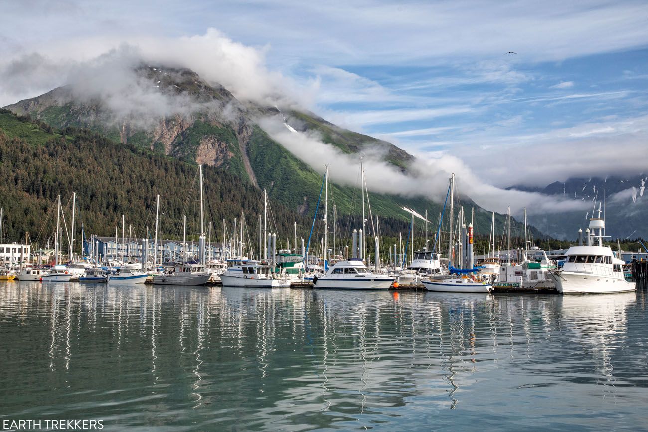
From the intersection of Herman Leirer Road and Seward Highway continue on Seward Highway another 2.5 miles and you will reach the main Seward harbor area. Here you will find many restaurants lining the harbor. And this is where the various Resurrection Bay excursions and the fjord excursions depart.
1.3 miles south of the harbor the Seward Highway ends at the Alaska SeaLife Center.
We suggest spending at least a couple of days in Seward. With one day, cruise to some of the coastal fjords within the national park. With a second day, you can go glacier kayaking, glacier hiking or ice climbing on the Exit Glacier, hike the trails in front of the Exit Glacier, or hike up to the Harding Icefield.
Top Experiences on the Seward Highway
That’s a long list of things to see and do. If you need help narrowing down the list on things to do between Anchorage and Seward, here are our favorite experiences from the drive:
- Beluga Point
- Dall Sheep
- Bird Point
- Glacier Creek Bridge Viewpoint
- Virgin Creek Waterfalls
- Portage Lake Overlook
- Tern Lake
- Moose Drop-In Trading Post
Count on these experiences taking 5 hours and 45 minutes (2 hours and 15 minutes just to drive the Seward Highway plus 3 hours and 30 minutes for these stops). Now add in one or more of the longer excursions (1 hour for Potter Marsh, 2 hours for Alyeska Aerial Tram, 1 to 2 hours for Alaska Wildlife Conservation Center, a stop in Whittier being measured in one-hour increments) and you can see how you need to pick and choose in order to manage your time.
Fortunately, Alaska has a lot of daylight during the summer months. 😊
The best experience of all is seeing Kenai Fjords National Park, both the Exit Glacier area and the coastal fjords. I intentionally left this off the top experience list above because its more ideal to save these experiences for a different day. But if Potter Marsh, Alyeska Aerial Tram, Alaska Wildlife Conservation Center, and Whittier do not interest you, then you could end your drive by hiking one of the trails in the Exit Glacier area.
9 Amazing Things to Do in Kenai Fjords National Park
Top things to do in Kenai Fjords, plus tips to have the best experience.Frequently Asked Questions
Will I Have Cellular Service on the Drive?
Don’t expect to have cellular service outside of the main towns. We recommend saving the interactive map at the beginning of this article to your Google account and then cache your Google maps before starting this drive.
Are there Gas Stations on the Drive between Anchorage and Seward?
We only saw one gas station in between Anchorage and Seward. It is located at the intersection of Seward Highway and Alyeska Highway near Girdwood. Therefore, we recommend filling up your vehicle in either Anchorage or Seward before starting this drive.
Should I Make any Reservations in Advance?
Advanced reservations should be made for any guided excursions (such as a guided hike) or any excursion with a limited number of seats, such as a cruise.
If you have any questions about how to drive from Anchorage to Valdez, or if you would like to share your experience, let us know in the comment section below.
More Information about Alaska
10 Days in Alaska: 3 Itineraries for Every Type of Traveler
Pinterest Facebook Flipboard We have taken two trips to Alaska. The first was a three-week road trip with our whole family, our kids were older teenagers at the time, covering Anchorage, Valdez, Wrangell-St. Elias, Denali, Kenai Fjords, Homer, Seward, and Katmai National Park. It remains one of the best trips we have ever taken as […]
Kenai Fjords National Park Travel Guide
Plan your visit to Kenai Fjords National Park. Learn about the best things to do, how to plan your time, where to stay, and more.
Northwestern Fjord Cruise in Kenai Fjords: Photos, Map & Is It Worth It?
The Northwestern Fjord Cruise is one of the best ways to experience Kenai Fjords National Park. You will venture further into Kenai Fjords National Park than any other cruise. By doing so you will maximize your chances of seeing a variety of marine and other wildlife, witness the allure and power of glaciers, and observe […]
Driving from Anchorage to Valdez: Best Things to Do, Map, & Photos
The drive from Anchorage to Valdez is gorgeous and it is packed with lots of great things to do. Along the drive, you can visit historical sites, hike on a glacier, feed a reindeer, learn about Musk Ox, see Dall sheep, photograph waterfalls, and stop at numerous viewpoints. This was our introduction to Alaska. And […]
Harding Icefield Trail: The Ultimate Hiking Guide
Hiking the Harding Icefield Trail in Kenai Fjords National Park is a challenging, rewarding, and unique experience all rolled into one. This memorable hike takes you past the Exit Glacier and ends with sweeping views across the Harding Icefield, the largest icefield that is located entirely in the United States. In this guide, we provide […]
Aialik Glacier Kayaking: Beauty & Adventure in Kenai Fjords
One of the best things to do in Kenai Fjords National Park is to cruise through the fjords, to see the glaciers that carved out this beautiful landscape. And if you are looking for adventure, kayak to Aialik Glacier, one of the more remote glaciers in Kenai Fjords National Park, Alaska. This experience combines a […]
Ice Climbing on the Exit Glacier | Kenai Fjords National Park
Are you looking for an adventure to add to your Alaskan itinerary? How about ice climbing on the Exit Glacier in Kenai Fjords National Park? This experience, from start to finish, is a blast. The day starts off with a short but tough hike up a portion of the Harding Icefield Trail. Once at the […]
16 Amazing Things to Do in Denali National Park
Discover the best things to do in Denali National Park, from bus tours along Denali Park Road and a flightseeing tour above the Alaska Range to spotting Alaska’s Big Five, hiking the Savage Alpine Trail, and visiting the famous sled dog kennels. Denali National Park is one of those places that redefines your sense of […]
9 Amazing Things to Do in Katmai National Park & Preserve
Katmai National Park & Preserve is a land of brown bears and volcanoes. It is wild, rugged, and remote and one of our favorite national parks. This national park is one of the best in the US for wildlife viewing. Every summer, brown bears head to the rivers, to feed on salmon. Brooks Falls is […]
Journey through Lake Clark National Park in Photos
Lake Clark National Park is one of the least visited national parks in the USA. Located in Alaska, not far from Anchorage, this rugged, remote park is home to some of the most magnificent landscapes in the National Park system. Steaming volcanoes sit amidst the jagged, glacier covered Chigmit Mountains. Waterfalls spill down from the […]

The Ultimate Guide to the 63 US National Parks
Stretching from the South Pacific, across the United States to the Caribbean, are 63 national parks. These national treasures preserve iconic landscapes, majestic mountains, primordial forests, arid deserts, misty coastlines, immense canyons, wildlife, and historic landmarks. We have visited 56 of the 63 US national parks, from the towering granite walls of Yosemite and the […]
US National Parks List: All 63 Parks, Map & Free Printable Checklist
There are 63 national parks in the United States, and we’ve visited 56 of them, from the remote wilderness of Denali to the coral reefs of the Virgin Islands. We’re a family of avid hikers who have spent over a decade exploring these parks, from multi-day backcountry trips to scenic drives with kids in tow. […]
United States Travel Guide: Places to Visit in the USA
Plan your visit to the United States. Learn about the best things to do, how to plan your time, road trip ideas, and sample itineraries.

Comments 12