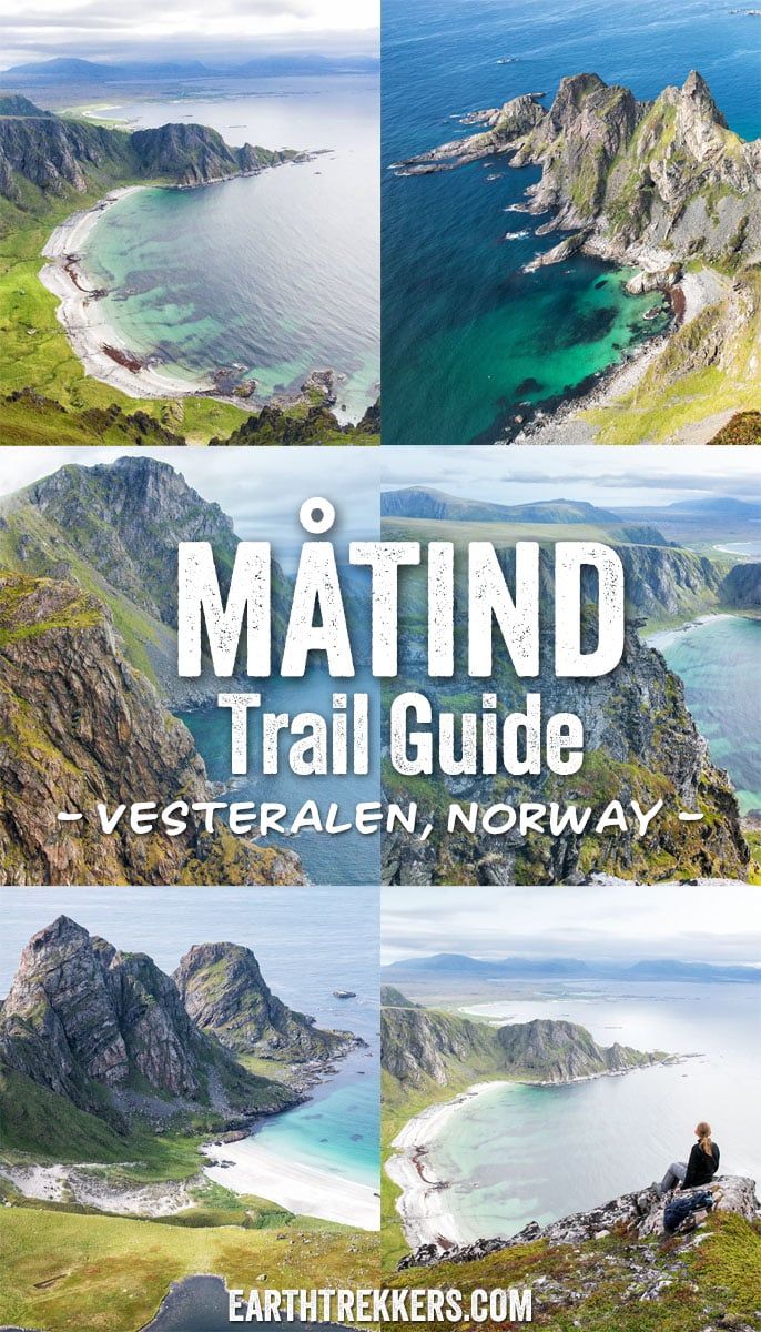
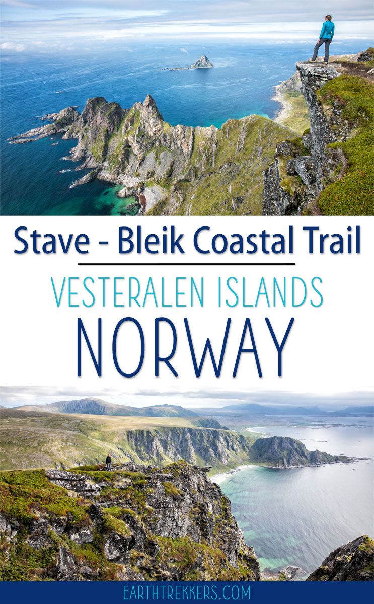
Norway has a way of exceeding every expectation, and the Stave-Bleik Coastal Trail on Vesteralen’s Andøya island is a perfect example. We hiked to Måtind in early July as part of a road trip from Tromsø to the Lofoten Islands, squeezing it in after a morning ferry crossing from Senja, and it turned out to be one of the most memorable hikes of the entire trip.
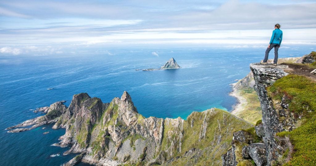
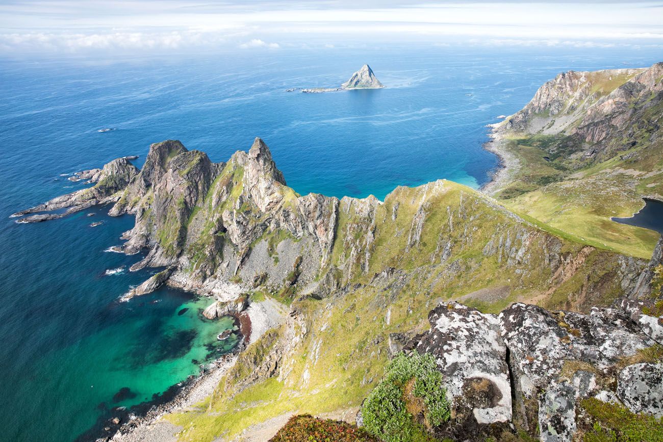
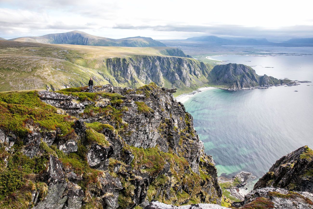
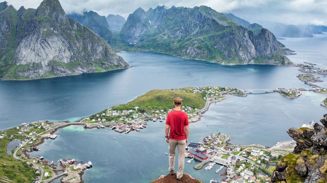
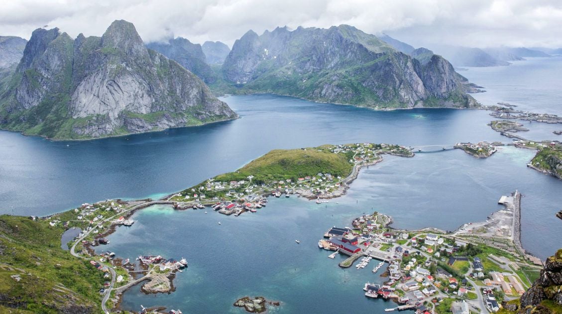
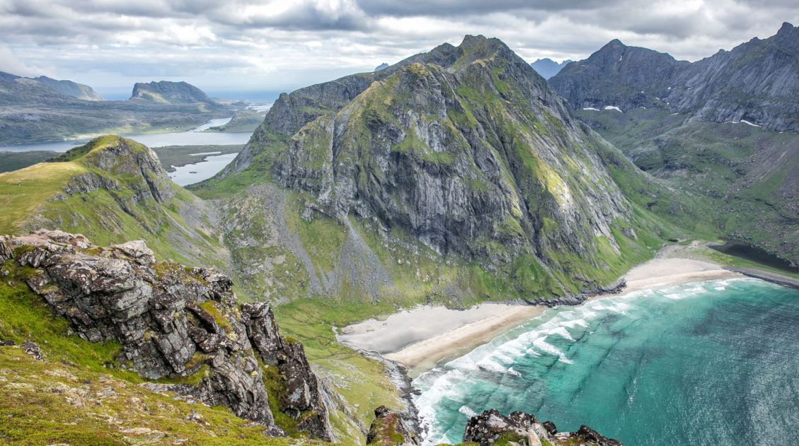
The trail follows the rugged coastline between the villages of Stave and Bleik, with Måtind rising as the dramatic high point in the middle. From the summit, you get unobstructed 360° views: the rocky peninsula stretching into the sea, the turquoise arc of Høyvika Beach, and the puffin nesting rock of Bleiksøya floating just offshore. The four of us had almost the entire mountain to ourselves.
This is not an overly difficult hike and most reasonably fit hikers will handle it comfortably. For a relatively short, easy hike, the scenery is extraordinary. If you are planning a road trip through northern Norway, this hike deserves a spot on your itinerary.
Here’s everything you need to know to do it.
Where is Måtind & the Stave-Bleik Coastal Trail?
Vesteralen is an archipelago located just northeast of the Lofoten Islands. People travel here to get a glimpse of sperm whales and humpback whales. During certain parts of the year you can also see puffins nesting on the smaller, rocky islands.
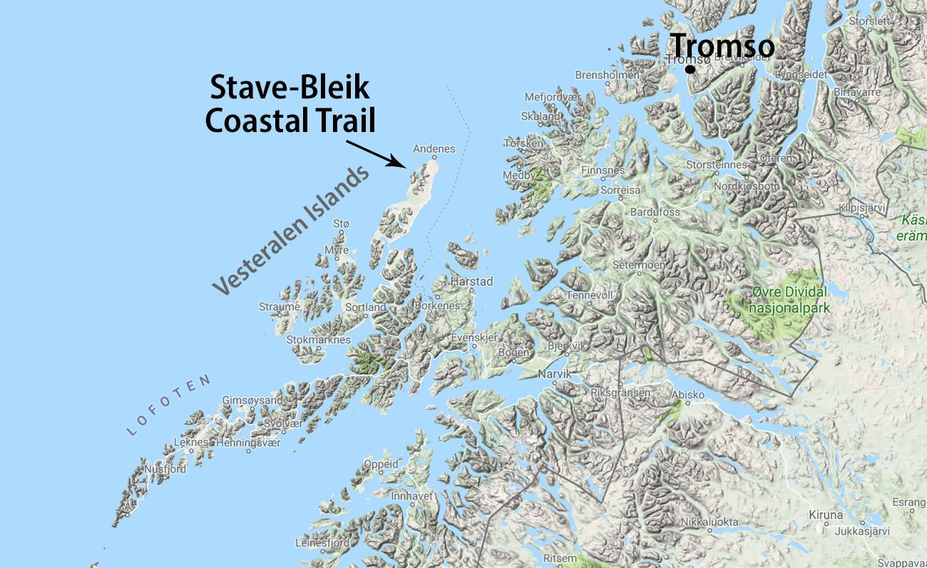
The landscapes here are very similar to the Lofoten Islands. It seems like many people skip right past Vesteralen (and it’s awesome little neighbor Senja) to the Lofoten Islands. That’s a shame, for them. Sure, the Lofoten Islands are dynamite, but they are missing out on some incredible scenery, quaint fishing villages, hiking trails, and those mighty whales. But it’s good for you. That means that there are less people on the trails, making this an awesome spot to go hiking.
I’m sad we only spent one day here.
If you have the time, a road trip from Tromsø to the Lofoten Islands is an amazing trip, just make sure you budget in some time for Senja and Vesteralen.
How Do You Get to the Stave-Bleik Coastal Trail?
We did this as a road trip from Tromsø to the Lofoten Islands. The day before, we hiked Segla on Senja (another awesome hike!!) and spent the night on Senja.
The following morning, we took the car ferry from Gryllefjord on Senja to Andenes on Andøya, one of the Vesteralen Islands. This ferry only runs during the summer months and only sails three times a day. You cannot reserve your spot in advance, you just have to get in line early. We took the first ferry of the day, at 11am. It takes 1 hour and 45 minutes to make the crossing to Andenes, so we arrived at 12:45 pm.
From Andenes, it takes 20 minutes to drive to the car park for the hike. Along the way, we stopped in Bleik to fill up our water bottles.
How to Hike the Stave-Bleik Coastal Trail
The trail is named for its starting and ending points: the town of Stave in the south and the town of Bleik in the north. It is 9 km in length, taking hikers past coastal beaches and coastal cliffs. Måtind is the highest point along the coast and this is the spot where you get the best views.
You can do this as a point-to-point hike, starting at one end and hiking to the other (the red route on the map).
Or, you can do what we did. Start near the midway point, hike to the top of Måtind for the best views of the day, and wander as far as you like towards Bleik and/or Stave (the blue route).
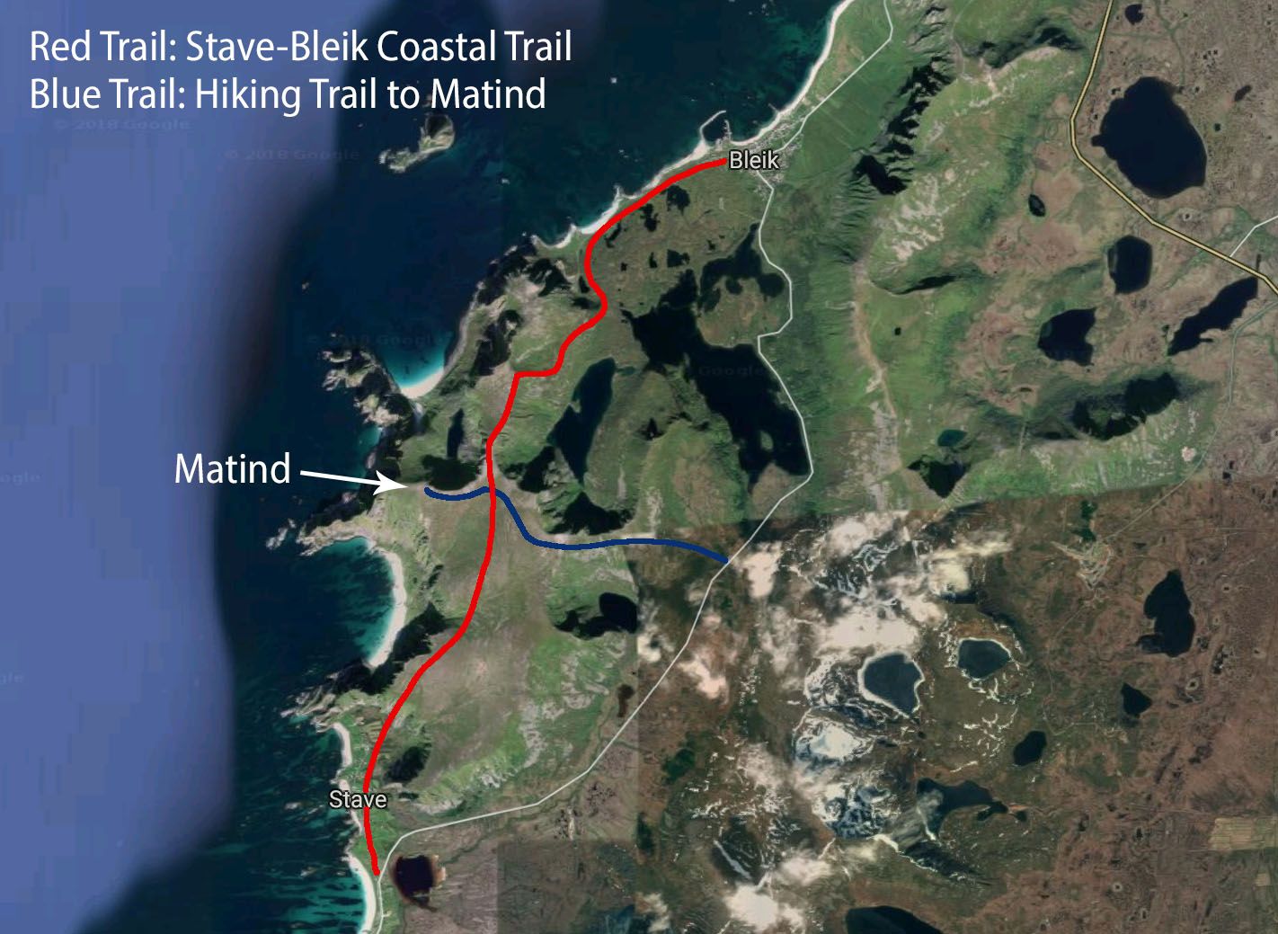
In this article, read about how to hike to the midpoint of the Stave-Bleik Coastal Trail, hike to the top of Måtind, and then make a quick detour towards Bleik.
Måtind Hiking Stats
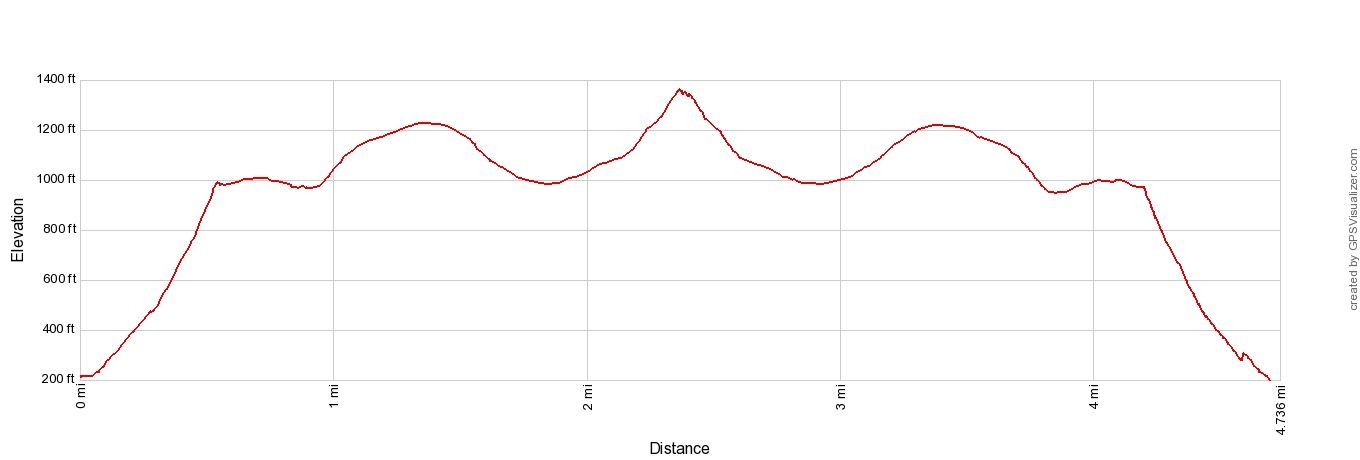
Distance: 7.6 km (4.7 miles) round trip to Måtind only
Total Ascent: 520 meters (1700 feet)
Difficulty: easy to moderate
Length of Time: 3 to 4 hours
If you plan to add on the detour towards Bleik, the total distance of the hike is 10 km (6 miles). This adds roughly another hour, depending on how far you go and how long you stop to enjoy the views.
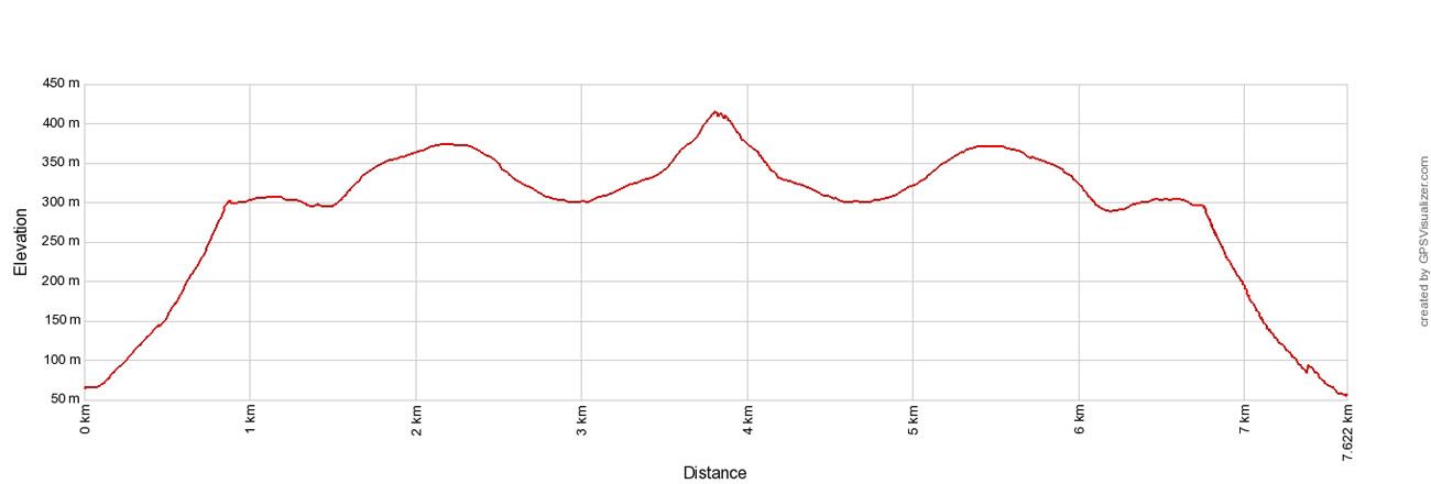
Elevation profile without the detour to Bleik.
Please practice the seven principles of Leave No Trace: plan ahead, stay on the trail, pack out what you bring to the hiking trail, leave areas as you found them, minimize campfire impacts, be considerate of other hikers, and do not approach or feed wildlife.
Getting to the Trailhead
There is a small car park located in Baugtua on Fv976 (GPS Coordinates: 69.235489, 15.949225). From Bleik, drive 5 km south on Fv 976 until you reach the car park. There are large signs marking the trailhead. Parking is free.
Hiking to Måtind: Step-By-Step Trail Guide
The trail starts next to the large signs. From this point, it is a 3.8 km walk to the peak of Måtind.
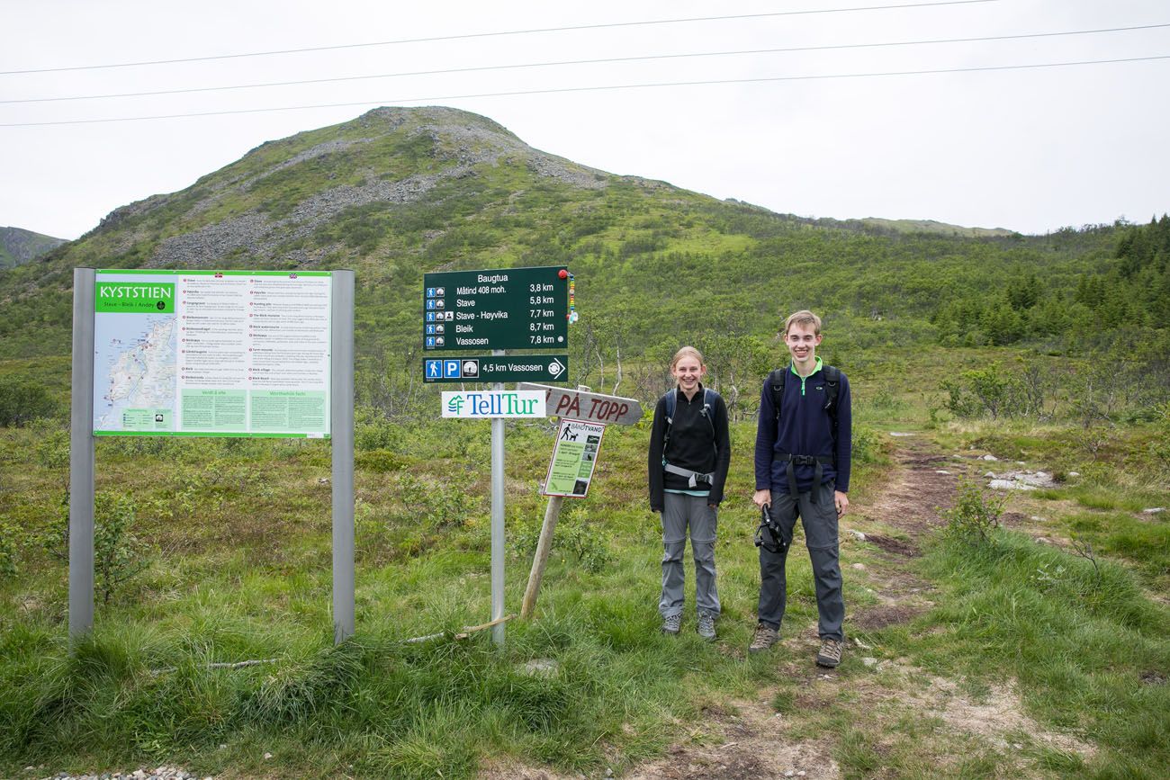
You can see the first, “big” climb behind the signs.
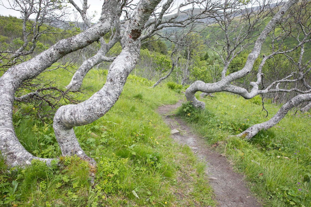
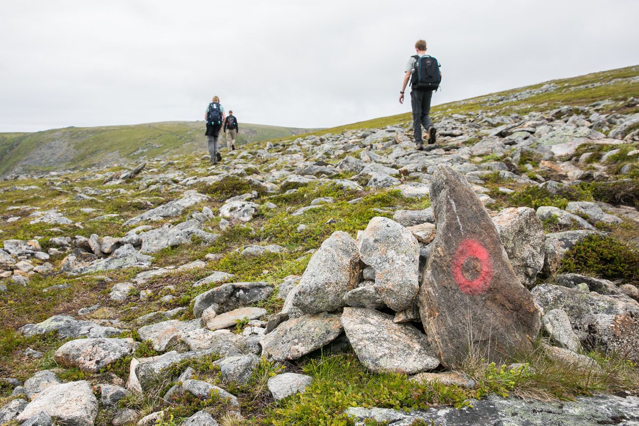
At first you hike through some short, twisted trees. The trail forks towards the end of the forest. Stay to the left and aim for the peak in front of you. The trail is marked by painted red circles.
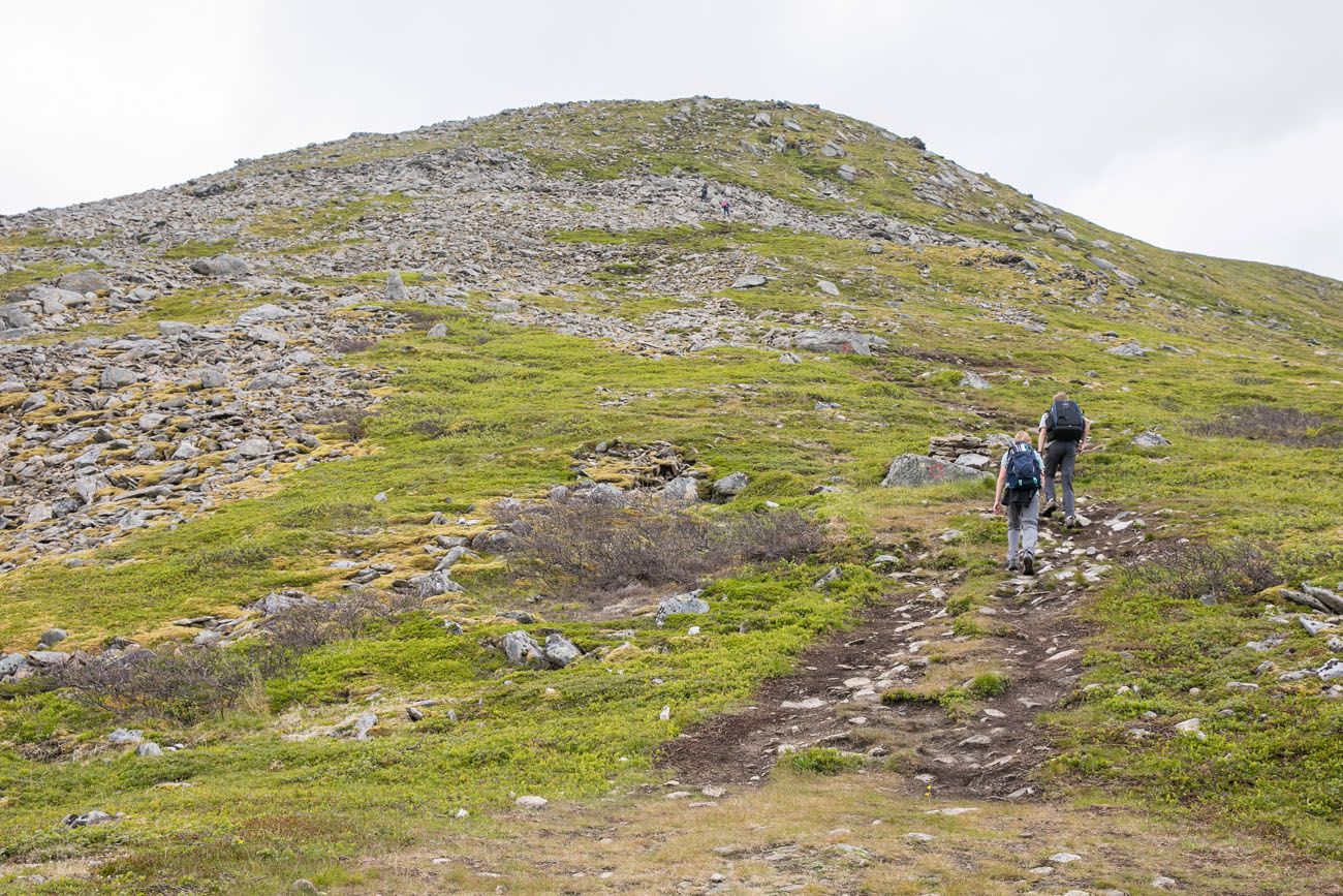
Once out of the trees, the trail quickly climbs up a steep trail with lots of rocks. This is the most challenging part of the hike, so once you are past this, the worst is over. Later in the hike there will still be some hills to climb but they are not as steep.
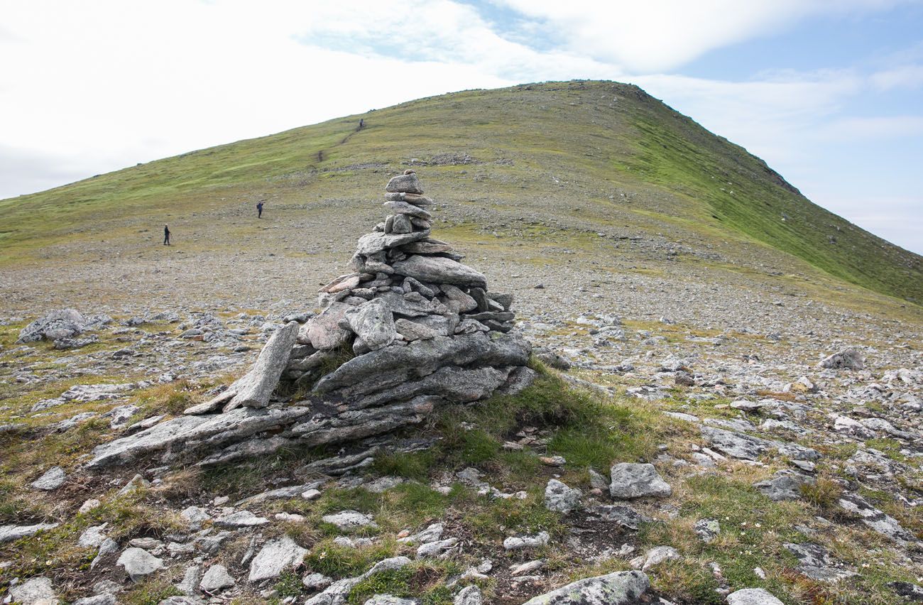
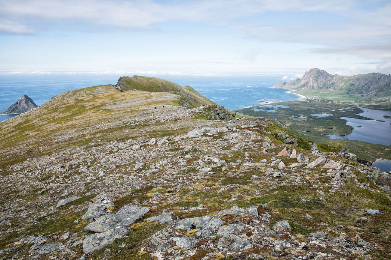
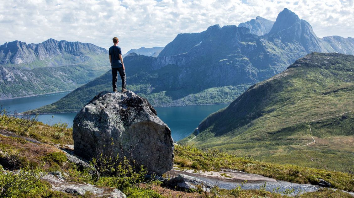
Once on top of the hill, the views really open up. The trail undulates along this higher, rocky plateau. It’s quick and easy walking. The trail is easy to follow and there are also cairns marking the way.
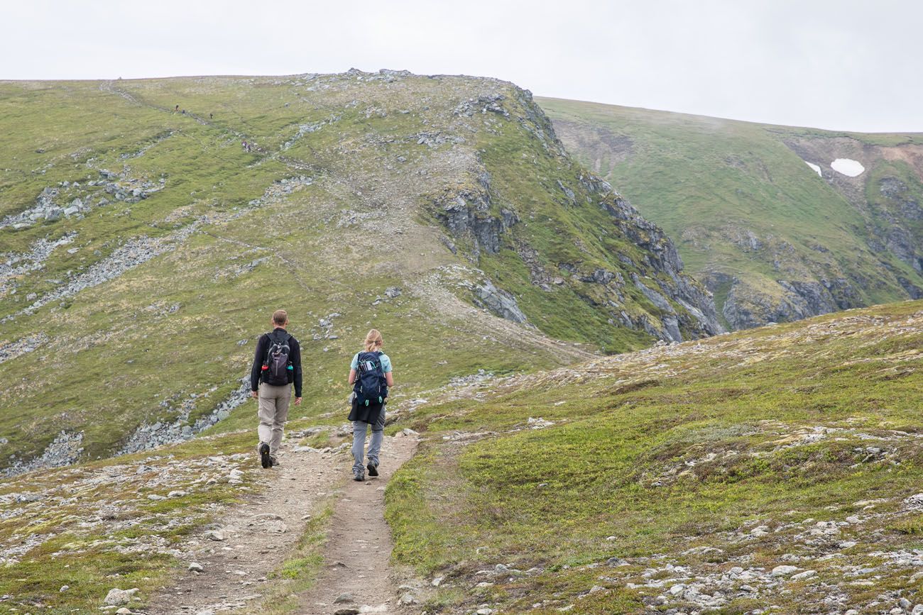
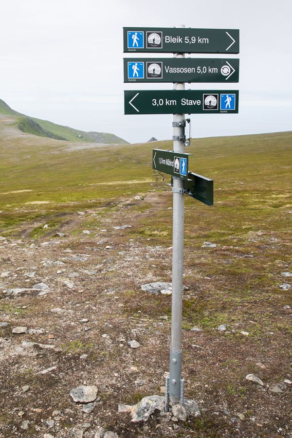
The trail tops out at a ridge. Continue down the trail for approximately 400 meters until you reach a sign marking your options. Continue straight to summit Måtind. Turn left to hike to Stave and turn right to hike to Bleik.
The hike up Måtind is relatively easy and straightforward. Simply follow the hiking trail to the top. From the bottom of Måtind, it takes about 30 minutes to get to the top.
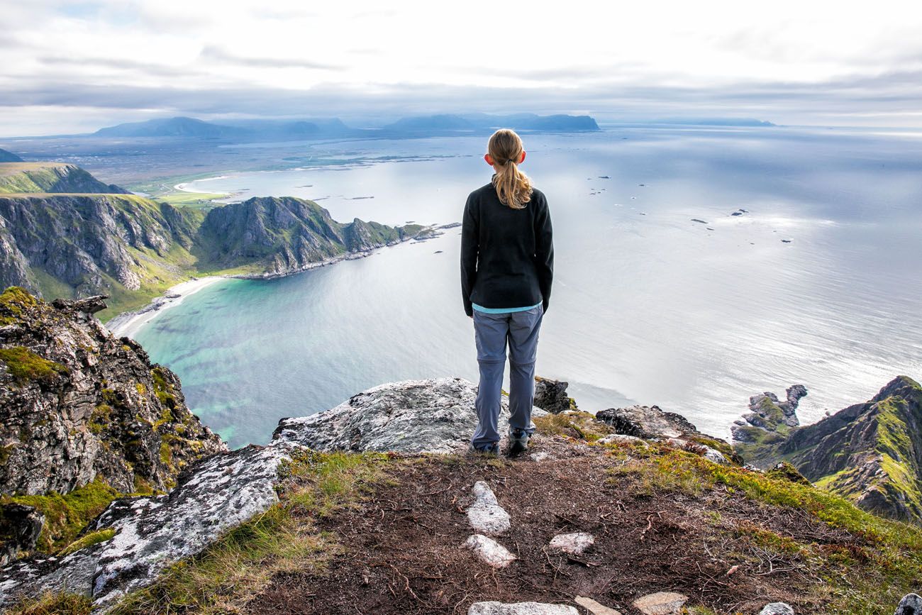
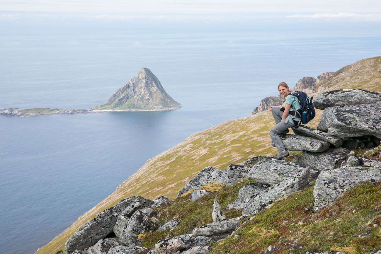
And wow, what a view! This is the highest point in the area, so you have 360° views out to Stave, down the rocky peninsula that juts off of Måtind, and down the trail you just walked up.
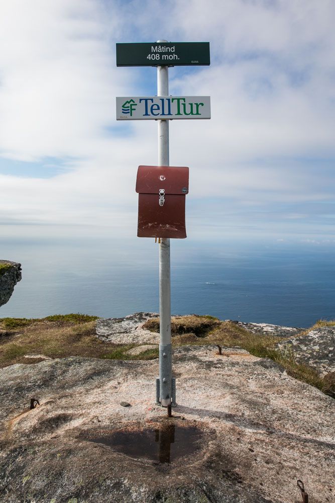
Take some time to explore the short trails and viewpoints on top of Måtind. Make sure you sign the “turboka,” the tour book.
We spent almost one hour up here. Tyler flew our drone and Kara and I explored the various viewpoints. We couldn’t decide what we liked more: the peninsula and the view out to Bleiksøya or the view out to Høyvika Beach.
Have fun deciding what your favorite view is!
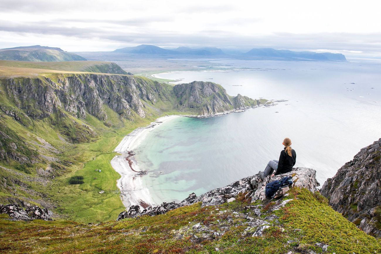
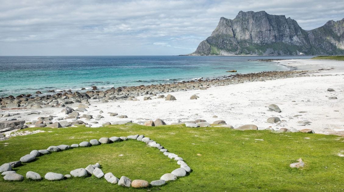
Looking out over Høyvika Beach towards Stave.
From here, you can hike directly back to your car or you can explore the trails that lead to Stave and/or Bleik.
From the top of Måtind, it takes approximately one hour to hike back to the car park.
Hiking towards Bleik
We also took some time to hike towards Bleik. We only walked for roughly one more mile (round trip), but just going that short distance offered us more amazing views. If you have the time and energy, this is worth it.
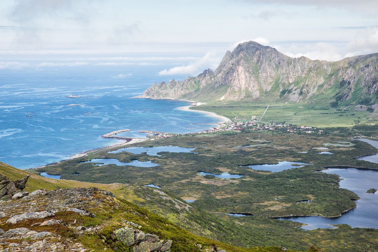
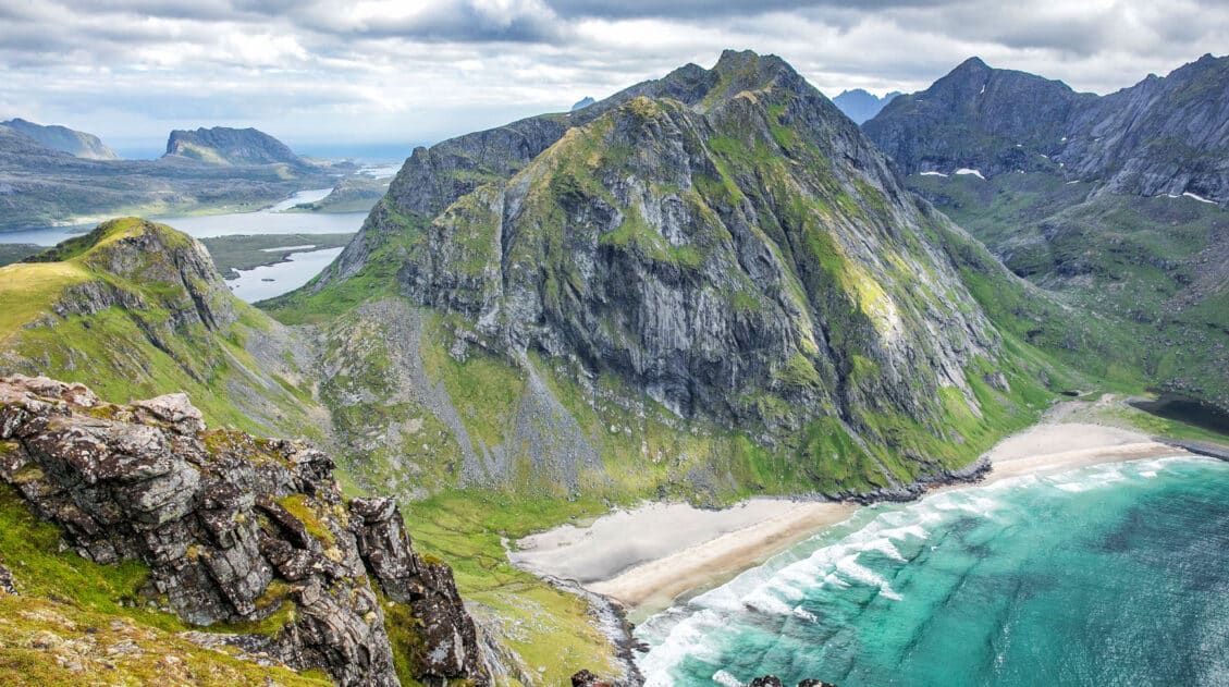
At first you get a closer view of the gorgeous beach next to Måtind. I never expected to see beaches like this in Norway. Nice, right? And there’s no one there, just a lot of sheep, their bells making music for all of us to hear.
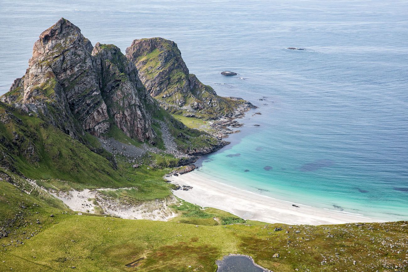
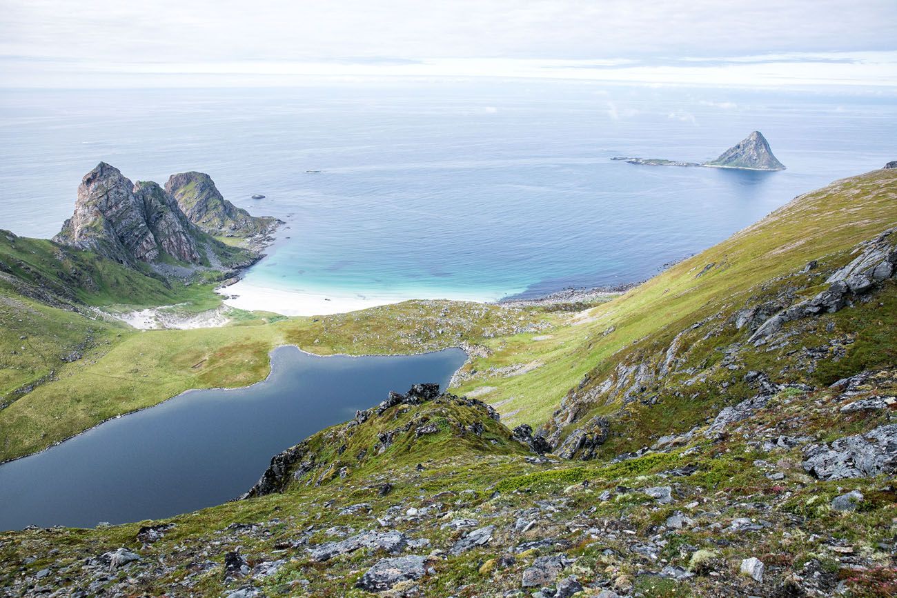
The small, rocky island is Bleiksøya, a nesting site for puffins.
If you walk a bit further towards Bleik, you get a really nice view of town with its own pretty beach and backdrop of jagged mountains.
Hiking to Bleik.
Hiking towards Stave
We did not do this, since we were running short on time. But if you hike towards Stave, you can get some really nice views looking back at Måtind. You also have the option to hike down to beautiful Høyvika Beach.
Video of Måtind and the Stave – Bleik Coastal Trail
Want to see a video of the entire hike? This includes some awesome views of the coastline captured by drone.
Best Time to Hike Måtind
We hiked Måtind in early July, arriving on the island in the early afternoon after taking the morning ferry from Senja. Despite a rainy crossing, the clouds cleared by the time we were on the trail and we had brilliant visibility from the summit. By the time we were back at the car, the low clouds had rolled back in. That’s Vesteralen weather in a nutshell: unpredictable, and worth going for it whenever you get a window.
July and August are peak season for a reason. This is when you get long daylight hours (including the midnight sun in late June and early July), the best chance of dry, clear weather, and access to the Gryllefjord–Andenes ferry from Senja. June is also excellent and tends to be quieter on the trails.
Spring (May–June): Shoulder season with fewer hikers and dramatic light. Snow may linger at higher elevations in May. The ferry from Senja typically doesn’t run until late May, so verify the schedule before planning around it.
Summer (July–August): Best overall conditions. Warmest temperatures, longest days, and all services operating. Expect the most company on the trail, though it’s still quiet compared to popular Lofoten hikes.
Fall (September–October): Moody skies and vivid autumn color make for beautiful photography, but weather becomes more unpredictable. Daylight shortens quickly through October. The Senja ferry stops running in fall.
Winter (November–April): Not recommended for casual hikers. Trails can be icy and dangerous, daylight is extremely limited, and many services in the area are closed.
Helpful Tips for Hiking to Måtind
The weather can change rapidly in Norway. It rained during our ferry ride from Senja to Andøya. Somehow, miraculously, the skies cleared up during our hike. However, by the time we were back in our car, low clouds moved in again and lingered until the following day.
You can do this hike with kids. We saw several young kids (about 8 to 10 years old) on the trail. There is the one strenuous climb at the start of the hike but it is not dangerous. The biggest risk here is twisting an ankle. Once you are on Måtind, do not let your kids get near the edge of the cliffs.
What to bring: hiking shoes or sturdy walking shoes, sunblock, water, snacks, your camera, and a warm jacket even in the summer. It can be cold and windy on Måtind.

Essential Hiking Gear: What Should You Bring on a Day Hike?
If you are new to hiking or are curious about what you should bring on a hike, check out our Hiking Gear Guide. Find out what we carry in our day packs and what we wear on the trails.After the Hike
There are not a lot of dining options in the area. We drove back to Andenes and had dinner at Lysthuset, a mediocre restaurant that serves pizza, fish and chips, and seafood. It’s nothing spectacular but it refueled us so we could be ready for another adventure tomorrow.
Where We Slept
Again, there aren’t a ton of options. We stayed at the Nord Fish Apartments, picking this place for its budget prices and decent reviews. It’s out in the middle of nowhere, in a cluster of communist-style buildings. The hotel runs fishing expeditions, so many of the people who stay here do so for the fishing. We had two enormous rooms that were spotlessly clean. But the old building echoes a lot and it felt more like a dormitory than a hotel. I would describe this hotel as clean and functional. If you are looking for “boutique” or “charming,” this is not your place.
If you are just two people, check out Apartment Utsikten in Andenes. This highly rated property offers a gorgeous sea view and is within walking distance of the center of Andenes.
Where We Went Next
The following morning we drove south to the Lofoten Islands. We spent the afternoon rock climbing iconic Svolvaergeita and hiking Svolvaer Fløya. And yes, Norway continued to amaze us! 🙂
Plan Your Northern Norway Adventure
Måtind is one of the highlights of a road trip through northern Norway, and it fits naturally into a bigger itinerary. If you are driving from Tromsø south toward the Lofoten Islands, Senja is a must-stop along the way. We hiked Segla the day before Måtind, and the two make a perfect back-to-back pairing. Ørnfløya, near Sommarøy, is another short but scenic option if you have a few extra hours.
From Vesteralen, most travelers head south to the Lofoten Islands, which deserve at least four to five days. The hike to Ryten and Kvalvika Beach is one of the best in the archipelago, and Svolvaer Fløya is a great introduction to Lofoten hiking right from the main town.
For a full overview of the entire route, our 10-day Northern Norway itinerary from Tromsø to the Lofoten Islands covers all the logistics and logistics of stringing it all together. And if you are still in the planning stages for Norway as a whole, our Norway Travel Guide is the best place to start.
Do you have plans to visit the Vesteralen Islands? Comment below if you have any questions or advice for our readers.
Explore More of Norway
Best Things to Do in the Lofoten Islands: 16 Epic Experiences
Pinterest Facebook Flipboard We arrived in the Lofoten Islands after driving down from the Vesterålen Islands, and on our very first day, we climbed Svolvaergeita and hiked Svolvaer Fløya. It was a long, exhausting, unforgettable day, and somehow, it set exactly the right tone for everything that followed. By the time we left four days […]
How to Hike Reinebringen (+ Where to Park)
Reinebringen, with its dazzling view over the fishing villages of Reine, Sakrisøy, and Hamnøy, is the most popular hike in the Lofoten Islands, and one look at the panorama from the top tells you exactly why. We hiked Reinebringen in 2018 with our kids, who were 13 and 15 at the time, before most of […]
Best Hikes in Norway: 14 Epic Trails for Every Level
For hikers, few places in Europe can match Norway. The hikes in Norway are endlessly varied and genuinely world-class, from the fjords of southern Norway, the jagged peaks of the Lofoten Islands, and the remote coastline of Vesterålen and Senja. Alongside the Dolomites and the Swiss Alps, this is one of our absolute favorite places […]
Where to Stay in the Lofoten Islands: Rorbuer, Hotels & More
If you’re trying to figure out where to stay in the Lofoten Islands, the first thing you need to know is this: the islands have their own iconic accommodation type, and it’s unlike anything else in the world. Rorbuer, traditional Norwegian fishermen’s cabins, typically perched on stilts over the water, are the reason so many […]
Norway Travel Guide: Fjords, Lofoten Islands & Svalbard
Norway Travel Guide There is nowhere quite like Norway. We’ve been to Norway twice, and both trips rank among the most spectacular we’ve ever taken. On our first visit, we road tripped through the fjord region in summer, hiking Trolltunga, Kjeragbolten, Pulpit Rock, and Romsdalseggen Ridge and cruising past some of the most dramatic scenery […]
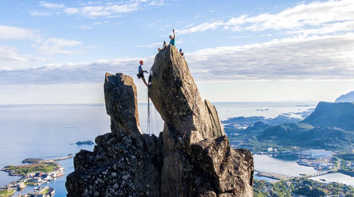
Complete Guide to Climbing Svolvaergeita in the Lofoten Islands
Svolvaergeita, also called “The Goat,” is a pinnacle of rock that is a popular rock climbing spot in the Lofoten Islands. It is named The Goat because of the two horns of rock that sit atop the rock. Those with a sense of adventure can climb to the top of Svolvaergeita and those who are […]
10 Days in Norway: How to Combine the Fjords and the Lofoten Islands
After two trips to Norway, one through the fjord region, one through the far north, we started getting the same question over and over in our comments: Can we combine both into one trip? How do we do the fjords AND the Lofoten Islands in 10 days? That’s exactly what this post is for. We’ve […]
10-Day Northern Norway Itinerary: Tromsø to the Lofoten Islands
We’ve done a lot of road trips in Europe, through the Italian Dolomites, across the Scottish Highlands, and down into the fjord region of southern Norway. This Northern Norway itinerary is one of our all-time favorites. We drove this route in early July, starting in Tromsø and working our way south through Senja and the […]
20 Best Things to Do in Norway: Fjords, Lofoten & Svalbard
Norway is one of our favorite countries in the world, and narrowing down the best things to do in Norway for this list was genuinely hard. There’s just so much worth doing. We’ve been twice so far, and we’re already dreaming about a third trip. Our first visit was a family trip with the kids […]
Hiking Ryten: Kvalvika Beach Views & Lofoten’s Mini-Trolltunga
The hike to Ryten has all of the ingredients of a perfect Lofoten Islands hike: sweeping vistas across the mountains and fjords, a fun but slightly strenuous hike to a mountain peak, and a breathtaking view of a white, sandy beach. The icing on the cake is a “mini Trolltunga,” an outcropping of rock where […]
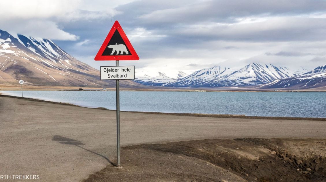
Svalbard Travel Guide & Itinerary for First Time Visitors
Svalbard. An arctic playground where there are more polar bears than people. This is a land of glaciers, the northern lights, the midnight sun, and frozen tundra. Svalbard may seem barren, but it is filled with arctic wildlife like reindeer, walrus, and polar bears. If you like the idea of exploring the great outdoors, your […]
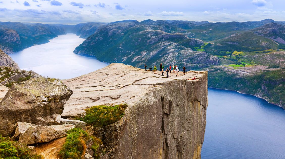
Hiking Pulpit Rock (Preikestolen): What to Expect, Trail Guide & Tips
The hike to Pulpit Rock (Preikestolen) was the first hike our kids ever did in Norway and it set the bar high. Tyler was 10, Kara was 8, and we’d spent the previous months wondering whether they were really ready for Norwegian hiking. We’d taken them on Old Rag in Shenandoah as a test run, […]
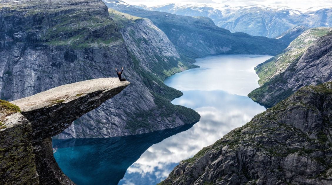
How to Hike Trolltunga: Everything You Need to Know
Trolltunga was the third hike on our first Norway trip, and by then we had a pretty good read on what Tyler and Kara could handle. They’d already done Pulpit Rock and Kjeragbolten, two hikes that would have been on most adults’ bucket lists, and they hadn’t complained once. Tyler was 10. Kara was 8. […]

Comments 11