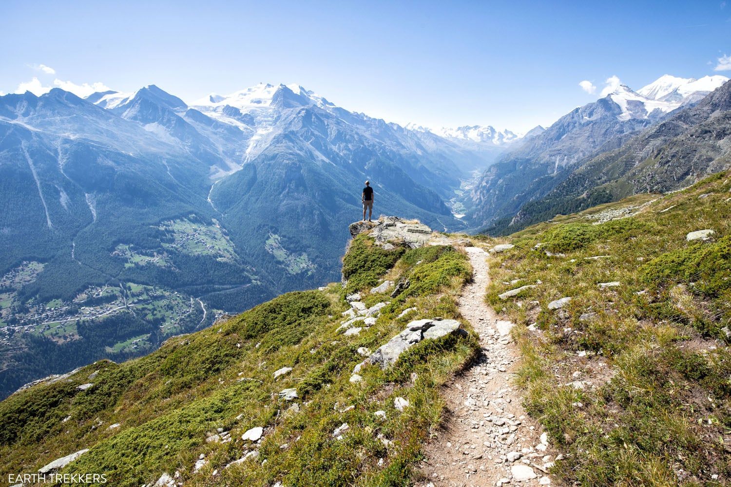
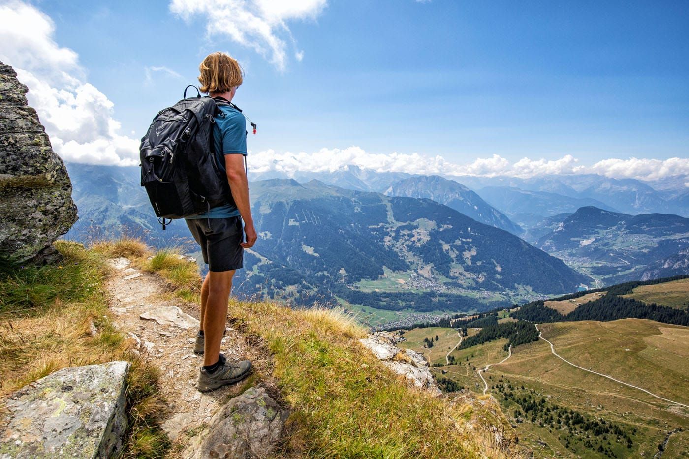
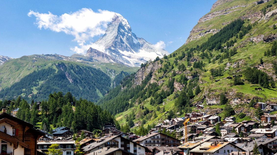
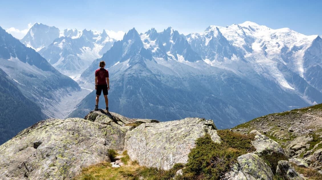
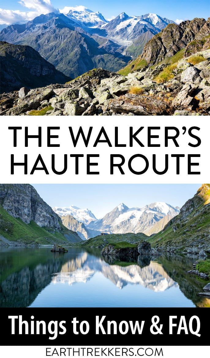
The Walker’s Haute Route is one of the most rewarding and memorable multi-day walks in Europe. On this journey, hikers will cross 10 of the highest mountain passes in the Alps, while walking from Chamonix, France to Zermatt, Switzerland.
It’s an extraordinary journey but not without its challenges. With 14 stages, multiple variations to the route, and a narrow window of time that the Walker’s Haute Route can be attempted, just planning it may feel like an adventure.
And then there are the physical challenges. The Walker’s Haute Route is one of the toughest multi-day walks in Europe, even more challenging than the Tour du Mont Blanc, so you will have to assess if you are even able to hike the full route. And some training and pre-trek hiking really pays off as well.
And finally, there may be things you never thought of. What is a typical day like on the Haute Route? What if the weather is bad? What will I eat? Where will I sleep?
In this guide, we hope to answer all of the questions you have about the Walker’s Haute Route, and maybe some you haven’t thought of yet. And if we missed something, let us know in the comment section below and we’d be more than happy to answer your questions.
Walker’s Haute Route: Questions & Answers
What is the Walker’s Haute Route?
The Walker’s Haute Route is a multi-stage walk through the French and Swiss Alps. It is usually walked from Chamonix, France to Zermatt, Switzerland.
In this direction, most of the mountain ascents are done first thing in the morning, on the side of the mountain that is still in the shade, until the morning sun gets higher in the sky. That way, most of the climbs are done in the shade, helping keep hikers cool.
There are multiple variations to the Walker’s Haute Route. The classic route has 14 stages, and during this journey, walkers will cross 10 of the highest mountain passes in France and Switzerland.
We hiked all 14 stages and made a few detours. Our distance came in at 204 km (127 miles) with 14,300 m (47,000 feet) of total ascent and 13,700 m (45,000 feet) of total descent. We hiked the Haute Route in 13 days from the end of July into early August 2022.
It takes most people 13 to 14 days to walk the Haute Route.
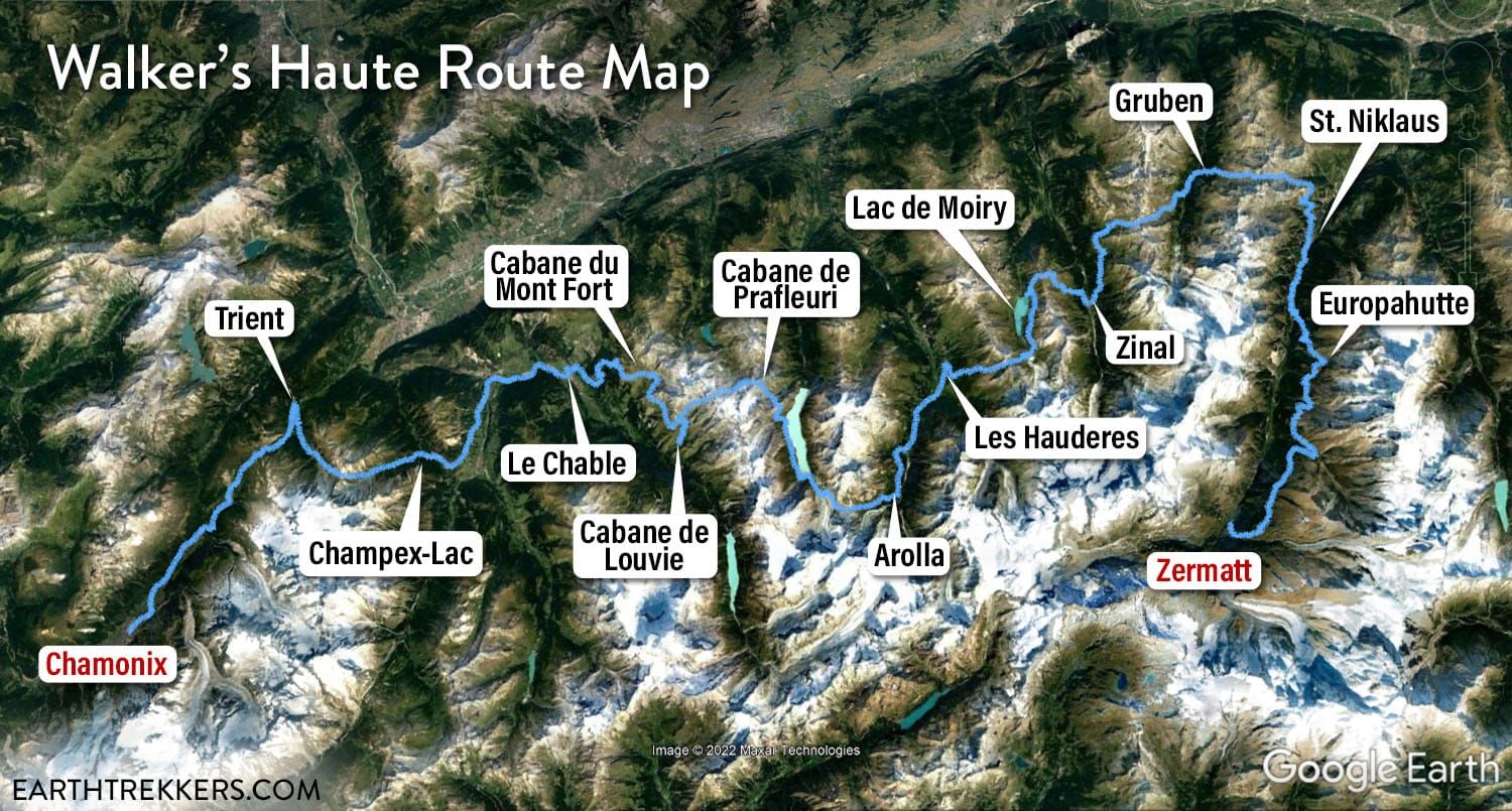
Walker’s Haute Route map
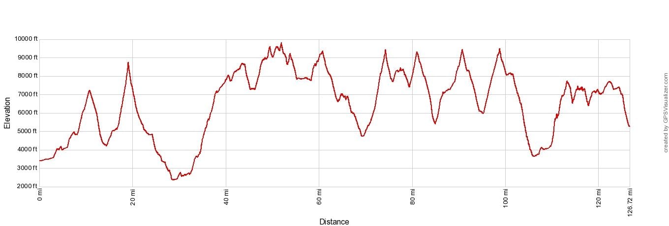
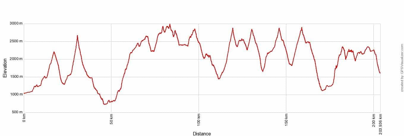
Walker’s Haute Route Elevation Profile
There is More Than One “Haute Route”
Dating back to the 19th century, the Haute Route originally started out as a mountaineering route and then became an alpine skiing route. The name “Haute Route” in French translates to “High Route.”
In the 20th century, as hiking trails were developed throughout France and Switzerland, a variation of the skier’s Haute Route was adapted to a walking route and became what we now know as the Walker’s Haute Route.
But this walking route is not the only “Haute Route” in the world.
The term “Haute Route” can also refer to the mountaineering route through the French and Swiss Alps, from Chamonix to Zermatt. To do this, you must have a very high level of fitness, mountaineering experience, and a knowledge of the Alps. This term also refers to the skiing route from Chamonix to Zermatt in the winter months.
Hauteroute.org is a company that hosts multi-day cycling events, where amateur cyclists can complete a 3, 5, or 7-day cycling route through the Alps or Pyrenees.
And as multi-day walks and treks grow in popularity, other countries are establishing their own “Haute Routes,” like this one in Norway.
A Typical Day on the Haute Route
On a typical day on the Walker’s Haute Route, hikers will walk about 16 km (10 miles) with 1,140 meters (3,740 feet) of total ascent. This takes 6 to 7 hours on average.
We like to get an early start. On most days, we would wake up between 6 and 6:30 am, pack up our day packs, and have breakfast. In every place we stayed, whether it was a mountain hut or a hotel, we would have some sort of breakfast. This was usually coffee, juice, meat and cheese, bread, muesli, and fruit.
On most days, between 7 and 7:30 am we would start hiking. And most days, we had about 6 hours of hiking, which meant that we were finished between 1 and 2 pm. We would sit down to a hot lunch and then check into our hotel or mountain hut, take showers, and relax for the rest of the day.
In the evening, we would have dinner and play cards and sometimes socialize with other hikers.
There is no need to get started that early, but it does have its advantages. It is cooler earlier in the day and the weather is better. Some afternoons, thunderstorms rolled in around 2 or 3 pm, and it’s a good idea to be off the trails when these storms roll through.
PRO TRAVEL TIP: Check the weather each day as you walk the Haute Route. Rain and storms can make some sections of the trail more dangerous, so it’s a good idea to keep tabs on the weather. We used and recommend the Swiss weather website MeteoSwiss (they also have an app for your smart phone). If you are in an area without cellular service, like one of the remote cabins, they will usually post tomorrow’s weather forecast so you know what to expect.
Tim and Kara on the Walker’s Haute Route
How Hard is the Walker’s Haute Route?
The Walker’s Haute Route is tough. We had multiple days where we hiked more than a mile in ascent (more than 1,600 meters), which is a lot of climbing to do. Before the Haute Route, we had only done this a few times (on Half Dome, the Enchantments, and hiking rim-to-rim in the Grand Canyon).
And the next day…it’s not a rest day. You may have to wake up and do it again.
We also did the Everest Base Camp trek in 2014. Tyler and Kara were just 10 and 11 at the time. In terms of hiking, the Haute Route is MUCH more challenging. The longer distances, massive ascents, and knee crushing descents make the EBC trek almost look flat.
But what makes the Everest trek difficult is the altitude. For most of the EBC trek, we were well over 10,000 feet, getting up to 18,000 feet at one point. This is fatiguing in a much different way.
On the Haute Route, you never get over 3,000 meters (10,000 feet), although you do get close a few times. Altitude sickness is not a concern, but it does take a few days to adapt to hiking at this higher altitude.
All four of us agree that the Haute Route is harder than the Everest Base Camp trek. The longer daily distances, the huge amounts of ascents, and very few rest days makes the Haute Route physically tougher than EBC in our opinion.
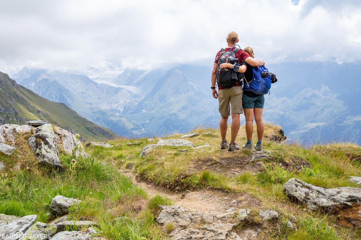
The view from Fênetre d’Arpette, Stage 3
How Fit Do You Need to Be?
You need to be very fit to hike the Walker’s Haute Route.
If you plan to hike the Haute Route, a 16 km/10-mile day with 1,100 meters/3,500 feet of total ascent should be easy for you, before starting this trek.
The day after day hiking does build up a level of fatigue that sticks with you to the end of the trek, so you need to have an excellent level of fitness before starting this walk, or you will be miserably tired and sore for most of it.
We were all doing long, hilly runs of 8 to 13 miles in the months leading up to the Haute Route. Before starting the Haute Route, we spent 9 days hiking in the Dolomites of Italy and 4 days hiking in the mountains around Chamonix, France.
We went into the Haute Route with a high level of fitness. Even so, the first few climbs were still tough.
As you progress through the Haute Route days, your level of fitness will increase. The big climbs get easier, partly because you are more fit, but also because I think you just mentally and physically adjust to day after day of big mountain ascents.
Tyler, who was 19 at the time and extremely fit, crushed the ascents and spent a lot of time waiting for us to catch up. Kara, by the end of the Haute Route, was right there with him. And Tim and I (at 51 and 47 years old at the time) were no slow pokes on the trail (but our kids made us look that way).
If you do any hiking after the Haute Route (if you plan to spend some time in Zermatt), you will fly up the hiking trails. Consider doing the climb up the Breithorn…it’s a 4,000+ meter ascent but the Haute Route training will have you well prepared for this mountain climb.
In conclusion, I recommend that you train for the Haute Route by going on long runs and/or doing back-to-back mountain hikes just before this trek. If you can do some of this hiking around 3,000 meters (10,000 feet) or higher, that’s an added bonus.
Col de Prafleurie, one of the highest mountain passes
When Can You Hike the Haute Route?
There is a narrow window of time that you can hike the Walker’s Haute Route.
This is typically done from mid-July through mid-September, when the trails are clear of snow.
Mountain huts open mid-June, but going this early, you risk hiking on trails that are still snow-covered, which could be dangerous.
We advise not starting the Haute Route until at least mid-July to ensure the trails are clear of snow, a little later would be even better. We spoke to a tour operator and they said the same thing. We started our Haute Route experience on July 24 and didn’t experience any snow on the trails but would see an occasional small patch of snow off-trail.
Walker’s Haute Route Stage 12
Do You Need a Guide for the Walker’s Haute Route?
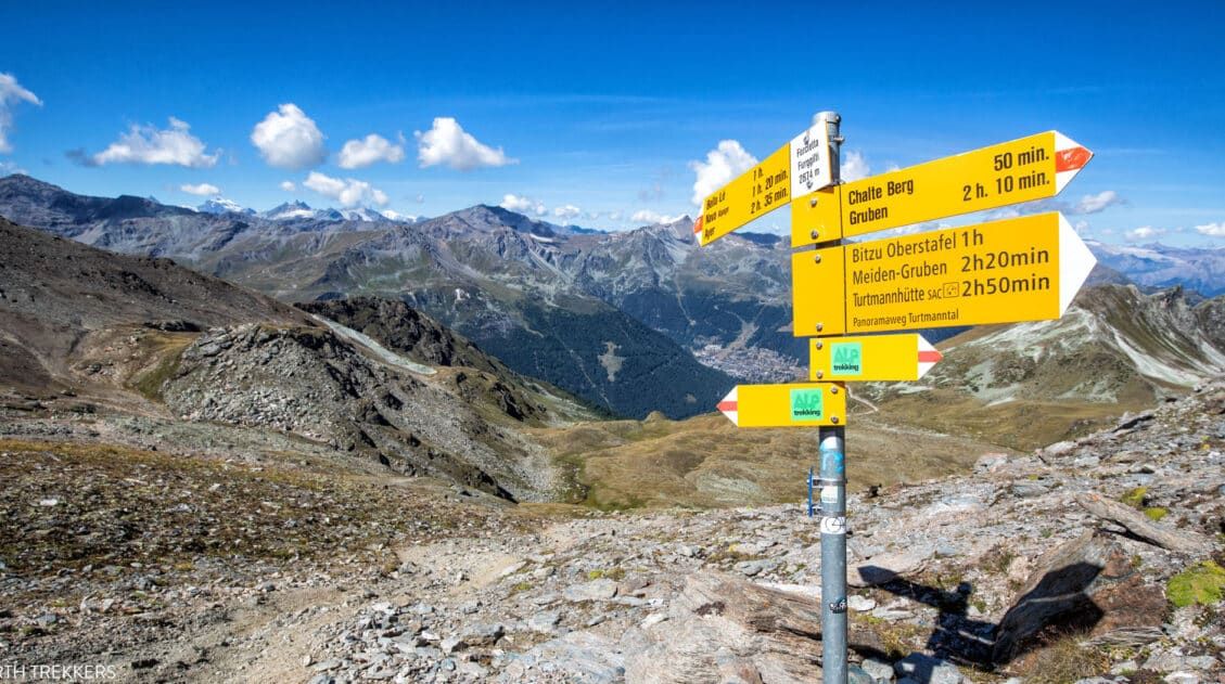
No, you do not need a guide for the Walker’s Haute Route. The trails are very well signed and easy to follow in Switzerland. A good guidebook (we recommend Trekking Chamonix to Zermatt, The Classic Walker’s Haute Route by Kev Reynolds) will explain the daily route and give you options to shorten it, should you have bad weather.
A digital map with the GPS track is also worth having. It makes it super easy to confirm that you are following the correct trail. We used the GPS data provided by TMBTENT in the Gaia app. The Gaia app has good background maps that you can download so you do not have to rely on cellular service. And the TMBTENT download includes information on how to set everything up.
While the digital map works great, make sure you still have a backup option, such as a guidebook, in case your mobile device breaks or runs out of battery power.
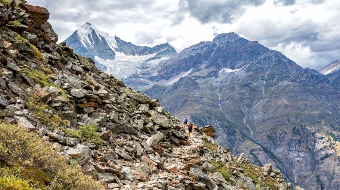
How Crowded are the Trails?
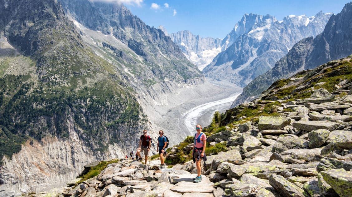
Most of the stages take you through remote territory. On these days, you will see just a few other Haute Route trekkers and a handful of day hikers. If our photos look like we were out on our own, that’s because we were (but getting an early start helps too). Most of the time, the Haute Route trails were wonderfully uncrowded.
The most crowded trails were stages 1, 2, and 3, when we shared the trails with those hiking the Tour du Mont Blanc.
The TMB is a much more popular trek and the number of hikers on the trails and in the hotels and lodges illustrated this. On these days, we encountered an almost steady stream of hikers coming towards us (the TMB hikers walk the same trails in the opposite direction).
Once on stage 4 (Champex-Lac to Le Chable) we left the TMB circuit and were on our own.
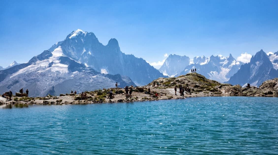
There are a few places along the Walker’s Haute Route where you will encounter some day hikers (Lac Bleu and Lac de Moiry), but this is not the norm. For the most part, stages 3 through 14 are rather empty.
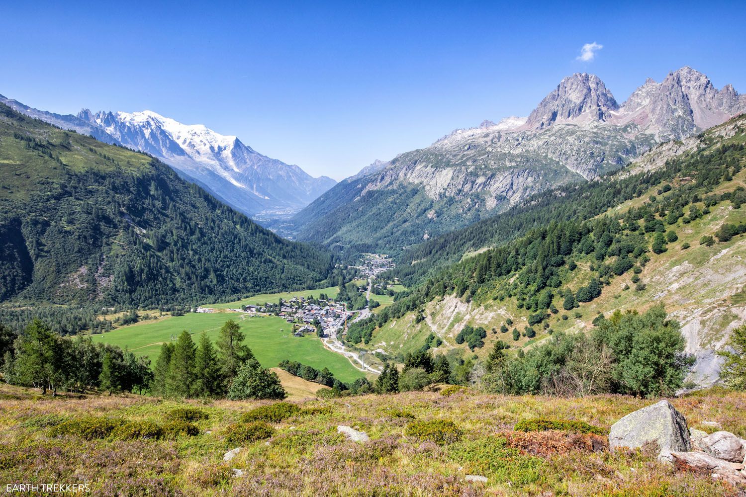
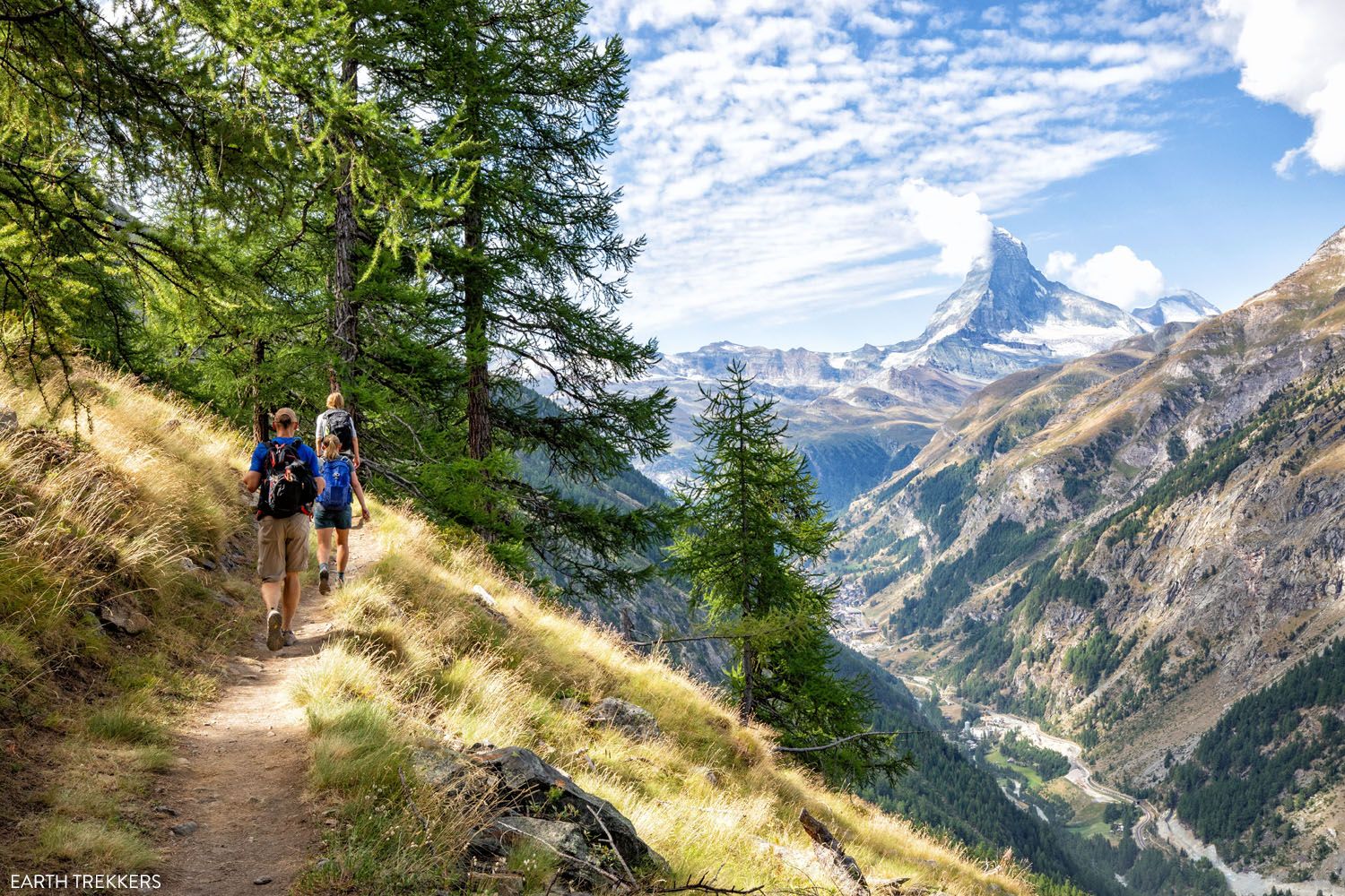
Walker’s Haute Route stage 2, a view of Le Tour and Mont Blanc
Should I Hike the Walker’s Haute Route or the Tour du Mont Blanc?
The Tour du Mont Blanc is a multi-day trek that loops around Mont Blanc. It is typically done in 11 days, has a distance of 180 km (110 miles), and has roughly 10,700 meters (35,000 feet) of total ascent. It is shorter and easier than the Walker’s Haute Route.
The Tour du Mont Blanc has been on our to-do list for a long time. It’s popularity and the fact that you hike around Mont Blanc sounds awesome. But ultimately, we chose the Haute Route because it sounded more interesting.
Walking across the French and Swiss Alps from Mont Blanc to the Matterhorn…how awesome does that sound? And doing so on a less crowded trail through a less touristy area, for us, the Walker’s Haute Route sounded like a better option. Plus, we loved the extra challenge of hiking the harder route.
I am so glad we chose the Haute Route.
For one thing, the TMB trails were very crowded, and so was the dorm that we stayed in in Trient. Once we left the TMB trails behind, the hiking was a much more pleasant experience.
And during our time in Chamonix, we had so many wonderful views of Mont Blanc that I don’t feel like it’s necessary to hike for 11 days for similar views.
If you don’t mind hiking a longer, more challenging route, and you want to hike through the Alps on quieter trails and experience more tranquility along the hike, pick the Haute Route.
But if you are looking for something shorter, easier, and more well known, then go with the Tour du Mont Blanc.
We spoke to several different people who did both and they unanimously agreed that the Haute Route is harder, but it is a more beautiful journey than the Tour du Mont Blanc.
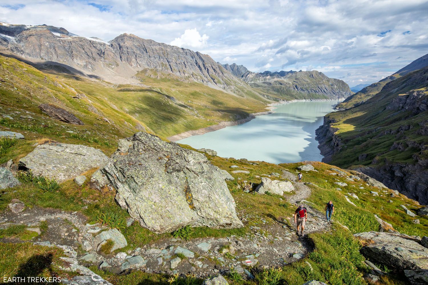
Lac des Dix, stage 7
The Haute Route is Not as Remote as You Might Think
On the Haute Route, you will spend days walking through remote landscapes and will stay in mountain huts far from the towns and hamlets. It’s not unusual, on some of these days, to see just a few other hikers on the trails.
But not every day is like this.
You will also have days where you walk from town to town, or descend under gondolas on slopes that are filled with skiers in the winter, or walk past lakes that are busy with day hikers.
Our favorite days were the more remote ones, where we felt like we were all on our own, gazing at majestic mountains and massive glaciers.
But walking through the Swiss towns, even though it may not sound as thrilling, has its advantages.
The Haute Route is more than just hiking through a rugged mountainous landscape. On this walk, you will also get to experience a less touristy side of Switzerland.
As you walk through the small towns, locals will put their heads out of the windows and say Bonjour! as you pass through town. In town, you can stop off at a café for a snack, some water, or to take a break. Outside of town, you will walk past farms and see cows, horses, goats, and sheep.
At times, you will walk along gravel roads, main streets of town, or even busier two-lane roads that run through Switzerland.
And almost every night, you will sleep in a small town or hamlet. And with that comes a hot dinner, the chance to stay in a hotel rather than a mountain hut or dorm, and have cellular service to stay in touch with friends and family.
Sembrancher, Walker’s Haute Route Stage 4
You’ll See a Lot of Cows
Since a lot of the Walker’s Haute Route trails pass through farms, you will see a lot of cows along this journey. The clanging of cow bells, and dodging a few cow pies here and there, becomes a common experience on the Haute Route.
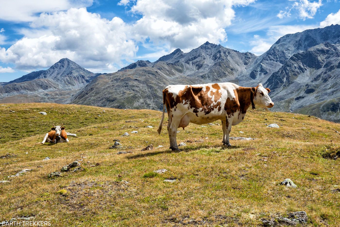
Cows on Stage 12 of the Walker’s Haute Route
And There’s a Good Chance You’ll See Ibex or Chamois
We spotted both ibex and chamois multiple times on the Walker’s Haute Route.
An ibex has long horns, is typically found above the tree line, and are usually unafraid of people. We saw ibex near Cabane de Prafleuri, along the mountain peaks near some of the highest mountain passes, and at the Europahütte.
Chamois are typically found where there is more vegetation, such as the forest or in areas with thick brush. They have a white face and smaller antlers. They are more afraid of humans, so if you spot one, they tend to run away almost immediately. We saw chamois on the walk between the Europahütte and Zermatt (stage 14).
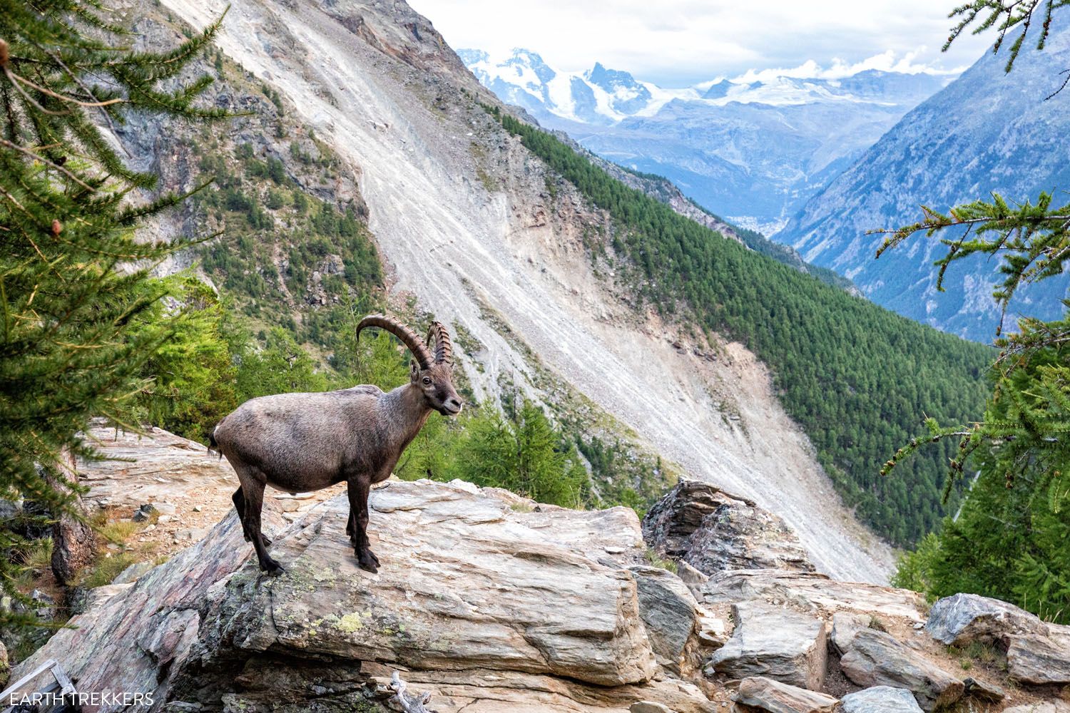
An ibex at the Europahütte
Will I Have Cellular Service?
For some of the time, yes. When stages end in a small town or hamlet you will have coverage there, and when you walk through towns as part of a stage you will typically have coverage.
Once in the more remote areas, you will lose the cellular signal. This can occur during a remote portion of a stage. It will also occur during complete stages, as we did not have service between Cabane du Mont Fort to Arolla…stages 6 and 7.
We used Airalo as our cellular e-SIM provider.
You Can Have a Hot Lunch Almost Every Day
One of our favorite things about doing the Walker’s Haute Route was the chance to have breakfast, lunch, and dinner every day. We started early enough in the morning that by the time we finished the stage, it was early afternoon. The four of us could sit down to lunch, dining on rosti, pasta, and cheeseburgers.
You can eat lunch at the end of every stage, although your choices at the end of Stage 2 are questionable. And for many of the stages you will pass places along the way where you can stop to eat lunch in order to take a break from hiking. But there are some stages where you will not find dining options along the way. These are stages 4, 6, 7, 9, and 11. If you want lunch on the trail these days, then check with your accommodations the night before to see if they can prepare a pack lunch for you. Many places offer this for an additional fee.
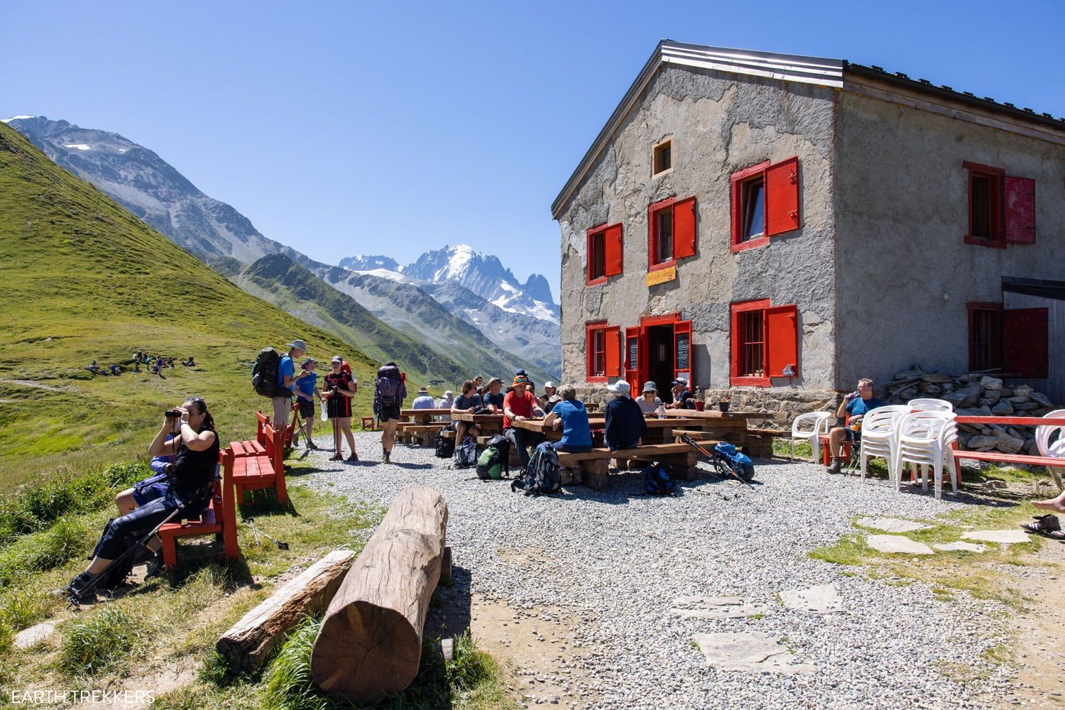
Refuge du Col de Balme
You Can Eat Whatever You Want
Six to seven hours a day of hiking, going roughly 16 km (10 miles) each day…we were HUNGRY. We typically ate four meals a day and ate whatever we wanted. Many days, even though we knew we could eat lunch at the end of the stage, we still ordered the picnic lunch from the hut/hotel in the morning, and ate it as a second breakfast, usually at the top of a mountain pass.
Tim and Tyler each lost more than 5 pounds on the trek. Kara and I lost less. But we were eating like crazy…cheese, meat, potatoes, ice cream sundaes, chocolate. Not the healthiest of diets, but it was a nice perk, to indulge for a week or two, without packing on the pounds.
Water along the Haute Route
Since there are stages where you can stop and eat along the way, you can also use these opportunities to rehydrate and/or replenish you water container. But don’t solely rely on this. Start each stage by carrying sufficient water based on your needs and the temperature.
Tim started the Haute Route by carrying 2.5 liters of water for himself at the beginning of each stage. After consistently having leftover water at the end of each stage he reduced this down to 2 liters to reduce weight. But he would also drink a ton once we finished each stage. Tyler on the other hand carried 2.5 liters and would consistently finish all of it before reaching the end of a stage.
Take extra water with you during stages 4, 6, 7, 9, and 11 since there are not places to buy it during these stages.
You will see water troughs along the Walker’s Haute Route. If you plan to use these then make sure you bring appropriate supplies to filter and sanitize the water, especially in the areas where farming occurs. We did not use any of the water troughs ourselves.
Stay in Mountain Huts, Apartments, and Even 5-Star Hotels
On the Walker’s Haute Route, you can stay in anything from a dormitory to a 5-star hotel.
The Walker’s Haute Route can be done without spending a lot of money. The dormitories are relatively cheap, averaging about $80 USD per person per day, which includes your bed, breakfast, and dinner (“half-board”). For a little extra, add on a packed lunch.
We have stayed in hostels and dormitories around the world, including mountain huts on the Everest Base Camp trek. The dorms in Switzerland are our least favorite. Small mattresses are lined up in one long line, and you could be sandwiched between two strangers, in a room holding 6, 8, 10 or more people.
Some dorms have rooms that can accommodate 2 people and 4 people, but these are hard to get (make your reservations in January or February) and not always guaranteed when you make your reservation.
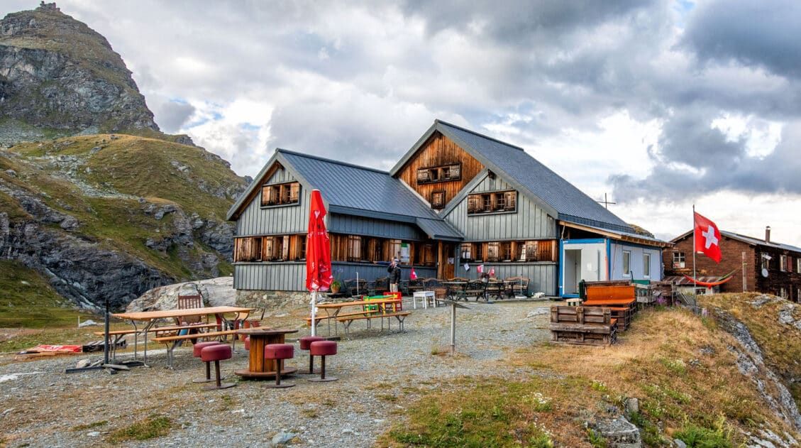
There are a few places where you have to stay in a dorm (mountain hut), since that’s all there is. On the list are Cabane du Mont Fort (end of stage 5), Cabane de Prafleuri (end of stage 6), Cabane de Moiry (if you choose not to stay in Grimentz at the end of stage 9), and the Europahütte (end of stage 13).
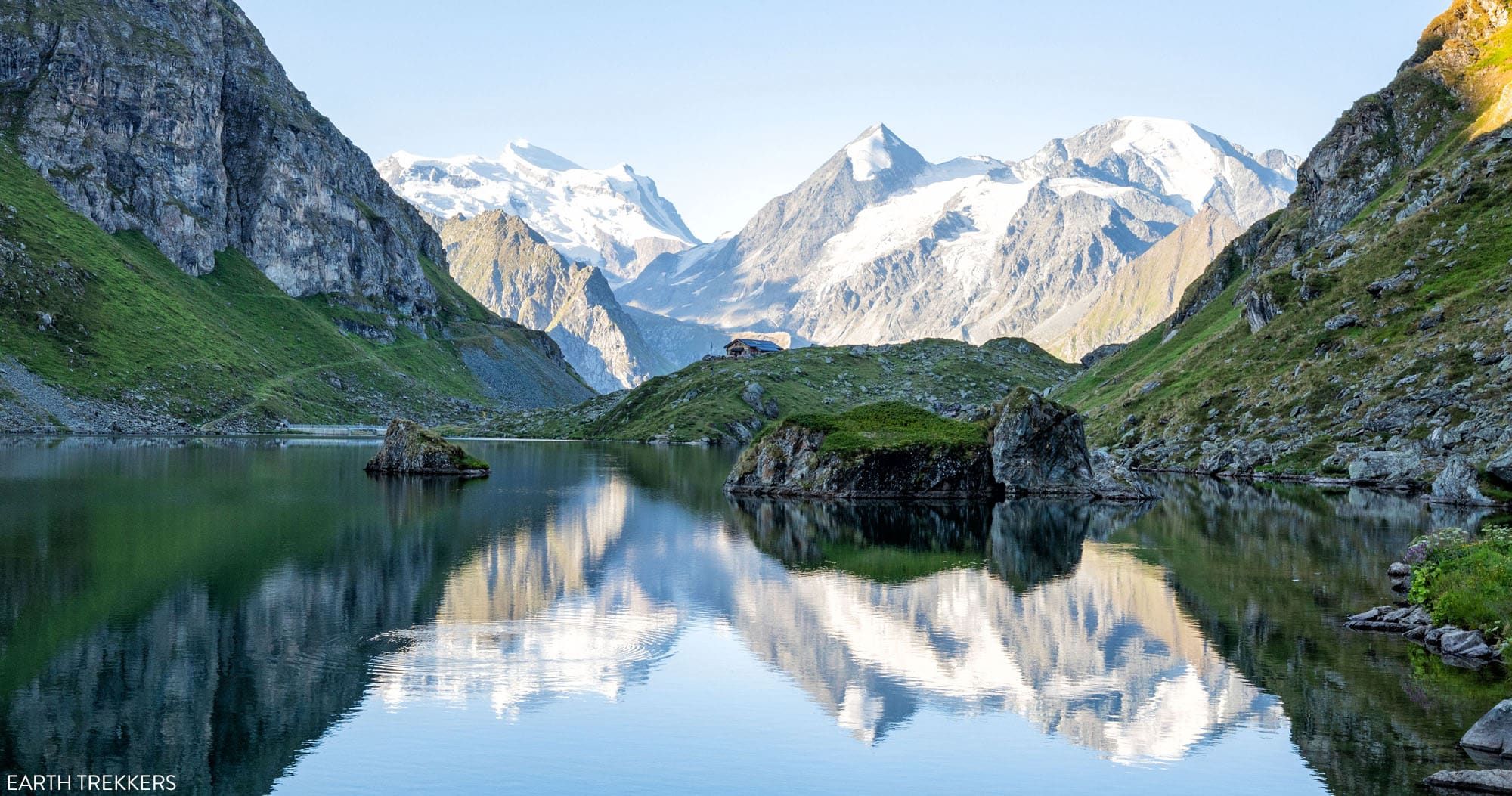
Cabane de Louvie was our favorite mountain hut. It’s located on a beautiful lake (it’s the header photo for this guide). Since it’s a detour off the main Walker’s Haute Route trail, this hut is less touristy and less crowded. It’s well worth the detour and a nicer place to stay than Cabane du Mont Fort.
If you plan to stay in the dorms for most of the trek, I recommend adding in a few hotels along the way. It’s nice to have some privacy, your own bathroom, and to escape being packed in a hot room with a bunch of people.
We only stayed in dorms/huts when necessary. Most of the time, we stayed in a hotel in town.
Our favorite places were Hotel Mont-Lac in Champex (we had an apartment and washing machine), Hotel Mélèze in Grimentz (small, cozy, clean, with impeccable service and an onsite restaurant), and Hotel Dents de Veisivi in Les Haudères (beautiful Swiss-style hotel).
In each of our Haute Route stage guides, we list where we stayed and give more options to look into. You can see all of these guides in our Walker’s Haute Route Travel Guide. And in our Guide to Booking Your Accommodations, we also provide suggestions on where to stay and how to book your Walker’s Haute accommodations.
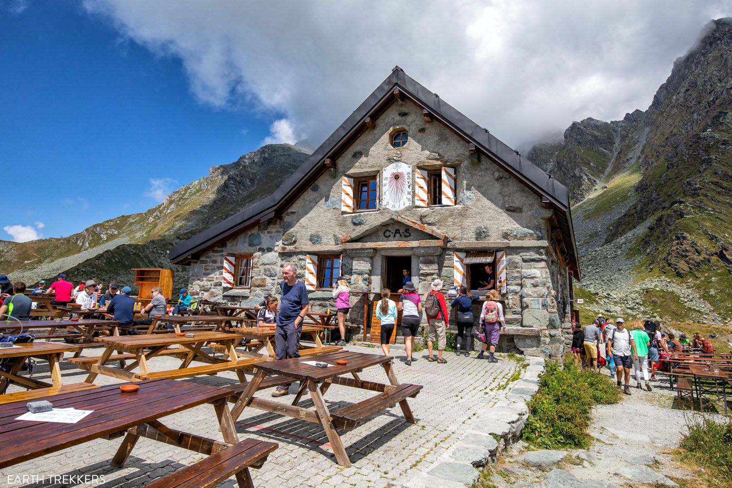
Cabane du Mont Fort
What about Luggage? Do I Have to Carry Everything With Me?
No. You do not have to backpack the Walker’s Haute Route if you don’t want to.
Since many stages end in town, and the towns are connected by roads, you can hire a luggage transfer service that will transport your luggage from hotel to hotel.
Each morning, we’d pack up our luggage and put it in the hotel lobby. At some point during the day, the luggage service would pick up our suitcases and drive them to the hotel in the next town. By the time we finished the stage and checked into the hotel, our luggage was there waiting for us.
There are a few stages where you cannot get your things, since you can’t drive to the more remote mountain huts. On these days, we had to carry what we needed in our day packs (change of clothes, toiletries, etc.) But this only happened a few times (stages 5, 6, 9 (if you stay at Cabane de Moiry) and 13).
The company we used is Taxi Follonier.
The view from the Sentier de Chamois
What if the Weather is Bad?
At some point, it will rain as you walk the Haute Route. We got lucky and this only happened a few days. And most of the time, when it did rain, it was in the afternoon or evening, so it did not affect our trek.
But if it does rain, or if storms are in the forecast, there are alternative routes to take during the stage (these are well outlined in the book Trekking Chamonix to Zermatt, The Classic Walker’s Haute Route by Kev Reynolds) to shorten it or avoid sections of the trail that could become dangerous in storms or rain.
Or, if the weather is really bad, it’s possible to completely skip many stages, by hiring a taxi or riding a bus from one town to another. The only time this is not possible is when hiking from Cabane du Mont Fort to Arolla (stages 6 and 7) since this is the most remote section of the Walker’s Haute Route.
It’s Easy to Skip or Shorten the Stages
If you don’t have a full 14 days to hike the Walker’s Haute Route, you can eliminate some stages. The best ones to skip are Stage 1 (Chamonix to Argentiere) and Stage 13 (walk directly from St. Niklaus to Zermatt in the valley, combining stages 13 and 14 to Alternative Stage 13/14).
You can also shorten stages, by riding the cable cars to eliminate big climbs or descents. Stages 5, 10, and 12 fall into this category.
Learn more about skipping stages and shortcuts in our guide on How To Plan Your Walker’s Haute Route Experience.
Haute Route Stage 10. You have the option to take the gondola and skip the downhill hike.
Is the Walker’s Haute Route Worth It?
Absolutely. This is an incredible journey across the French and Swiss Alps. Walking from Chamonix to Zermatt takes you to remote mountain huts, to tiny hamlets on the mountainsides, and small villages in the valleys. Along the way, you get to see some of the most breathtaking views of the Alps. It’s a tough trek but you will make some incredible memories that you will cherish for the rest of your life.
Final stage of the Walker’s Haute Route
Frequently Asked Questions
How long does the Haute Route take?
In total, the Walker’s Haute Route is 209 km (130 miles) with 14,800 meters (48,500 feet) of total ascent. Most people do this in 13 to 14 days, averaging about 16 km (10 miles) per day.
How hard is the Haute Route?
The Walker’s Haute Route is tough. On the average day, you will hike 16 km (10 miles) with 1,100 meters (3,500 feet) of ascent. And you will do this 13 times in a row, if you complete the Haute Route in 13 days. With the daily long distances, big climbs, and sometimes painful descents, this is a tough trek and it’s known as one of the hardest multi-day walks in Europe.
Do you need a guide for the Haute Route?
No, you do not need a guide for the Walker’s Haute Route. The trails are very well signed and easy to follow in Switzerland. A good guidebook (we recommend Trekking Chamonix to Zermatt, The Classic Walker’s Haute Route by Kev Reynolds) will explain the daily route and give you options to shorten it, should you have bad weather.
A good digital map with the GPS track is also worth having. We recommend using the GPS data provided by TMBTENT in the Gaia app. The Gaia app has good background maps that you can download so you do not have to rely on cellular service.
What do you do with your luggage on the Haute Route?
You can either backpack the Walker’s Haute Route (carrying everything in a backpack) or you can hire a luggage transfer service. The transfer service will transport your luggage from one hotel to another, so you never have to carry your things, other than a small day pack.
If you have any more questions about the Walker’s Haute Route, let us know in the comment section below.
More Information about the Walker’s Haute Route
Ultimate Guide to the Walker’s Haute Route
Pinterest Facebook Flipboard Walker’s Haute Route The Walker’s Haute Route is one of the most rewarding and memorable multi-day walks in Europe. On this trek, hikers cross 10 of the highest mountain passes in the French and Swiss Alps, as they walk from Chamonix, France to Zermatt, Switzerland. Walking from Chamonix to Zermatt takes you to remote mountain […]
Walker’s Haute Route Stages: An Overview of All 14 Stages
The Walker’s Haute Route is a multi-day trek from Chamonix, France to Zermatt, Switzerland. On this walk, hikers will cross 10 mountain passes, walk through small towns and through rugged, remote landscapes, and get to experience a less touristy side of the Swiss Alps. There are several routes that take hikers from Chamonix to Zermatt. […]
How To Book Your Walker’s Haute Route Accommodations
Along the Walker’s Haute Route, there are a variety of accommodation types, from mountain huts to 5-star hotels, from dormitories to apartments, and from shared bathrooms to private bathrooms. You will have the opportunity to experience a combination of all of these since you will be staying in a new place at the end of […]
How To Plan Your Walker’s Haute Route Experience
The Walker’s Haute Route is a 14-stage trek from Chamonix, France to Zermatt, Switzerland. It is a tough yet rewarding experience through the French and Swiss Alps that crosses 10 mountain passes and offers incredible scenery along the way. It is a beast of a trek! It took us 13 days, averaging 16 km (10 […]
20 Amazing Things to Do in Zermatt, Switzerland
Zermatt is an idyllic mountain village tucked away in the Swiss Alps. The mighty Matterhorn dominates the skyline, creating one of the most unique alpine landscapes in Europe. Explore the hiking trails, journey up higher into the mountains by cable car and train, stroll the scenic streets of Zermatt, and go skiing all year long. […]
Complete Guide to the Hörnlihütte Hike (Map, Trail Stats & Photos)
The Hörnlihütte (Hörnli Hut) is a lodge built at the base of the Matterhorn. For thrill seeking rock-climbers, the Hörnlihütte marks the start of the ascent up to the peak of the Matterhorn. Even if you do not wish to stand on top of the Matterhorn, simply hiking to and from the Hörnlihütte makes for […]
12 Epic Day Hikes in Zermatt (+ Trail Stats, Photos & Map)
One of the best ways to explore Zermatt is on foot. Hiking trails climb high into the mountains above Zermatt, past Swiss hamlets, through scenic valleys and rocky gorges, and to some of the best viewpoints of the Matterhorn. The network of cable cars and trains takes you up into the mountains, so for the […]
Matterhorn Glacier Trail: Ultimate Trail Guide (+ Map, Photos & HELPFUL Tips)
The Matterhorn Glacier Trail is one of the easiest and most scenic hikes to do in Zermatt. This point-to-point trail weaves its way between alpine lakes and along the way you get up close views of the Matterhorn. Since it is done one-way and is a mostly downhill hike, this is a great trail for […]
Switzerland Travel Guide: How to Plan a Trip to Switzerland
Switzerland Travel Guide Looking to hike some of the world’s most beautiful mountain landscapes, stroll through colorful old towns, and dine on some fondue? Then Switzerland is the perfect place for you! Visit the Bernese Oberland, a hikers paradise filled with towering mountains, alpine meadows, historic cogwheel trains, and quaint villages. Or, relax at Switzerland’s […]
24 Best Things to Do in Chamonix, France in the Summer
Discover the best things to do in Chamonix, France in the summer. This guide covers the top cable cars, hiking trails, glaciers, and adventures in Chamonix, based on our firsthand experience hiking and exploring the area. Chamonix is one of the most spectacular mountain destinations in Europe, and in the summer, it’s an outdoor playground […]
Grand Balcon Nord Hike: Best Direction, Hiking Stats & Tips
The Grand Balcon Nord is one of the best hikes in Chamonix. This trail runs above the valley, offering sweeping views of Mont Blanc at one end and Mer de Glace, France’s largest glacier, at the other. Tim, Tyler, Kara, and I hiked it in July as part of a five-day visit to Chamonix before […]
How to Hike to Lac Blanc, Chamonix (Photos, Stats & Map)
There are several reasons why the hike to Lac Blanc is one of the best in Chamonix. For one thing, this alpine lake is beautiful. A series of gondolas and chair lifts lop off the first big climb, making this hike doable for most ages and ability levels. But one of the best reasons to […]
France Travel Guide: How to Plan a Trip to France
Travel information and advice for France. Best things to do in France with itineraries for Paris, the French Riviera, and the Alsace wine region.

Comments 12